MY 2022 ATLANTIC HURRICANE SEASON BIRDSEYE VIEW POST #35
- NCHurricane2009

- Jun 17, 2022
- 5 min read
*******Note that forecasts and outlooks in this post are NOT the official forecast from the National Hurricane Center (NHC). They are my own detailed views on the Atlantic tropics based on current observations and latest computer model runs. As such do not make decisions based on my posts...consult news media...watches and warnings from your local weather office...and any evacuation orders issued by local governments to make the most informed and best decisions. Visit the NHC website hurricanes.gov (hurricanes dot gov) for the latest watches/warnings and official forecasts on active tropical cyclones.**********
…UPDATE… SATURDAY JUNE 18 2022 12:00 AM EDT...
Eastern Pacific Tropical Storm Celia interacting with Area of Interest #6 was recently downgraded to a tropical depression. See the NHC website hurricanes.gov (hurricanes dot gov) for more information on Celia as this site is dedicated to Atlantic tropical activity.
…FRIDAY JUNE 17 2022 11:55 PM EDT...
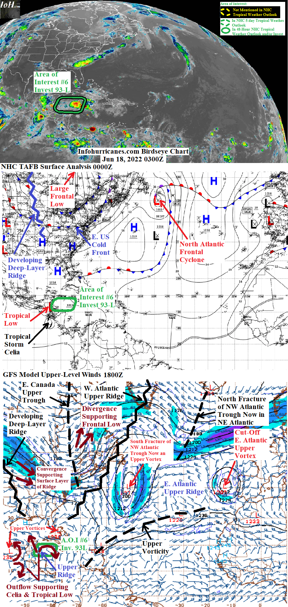
See Area of Interest #6 section below for an update on the low pressure area which is currently in the western Caribbean Sea en route to Belize.
Elsewhere… the tail end of the cold front currently rolling across the eastern United States is expected to settle in the northeastern Gulf of Mexico in 48 hours. While a deep-layer ridge over the United States is expected to build to the northwest of the front and provide a low shear environment… the latest model runs continue to suggest that this ridge will also cut-off some of the upper vorticity tied to the frontal system and send it southwest into the northeastern Gulf of Mexico where it could suppress upper outflow. Therefore tropical development in the northeastern Gulf of Mexico is not anticipated.
For the central Caribbean Sea… the aforementioned cut-off upper vorticity forecast to be in the Gulf of Mexico may aid to increase thunderstorm activity and drop surface pressures in about four days… due to a zone of upper divergence to setup between the south side of the upper vorticity and north side of a low-latitude tropical upper ridge over Central America. Any unfavorable wind shear induced by the upper vorticity is then likely to fade as the upper vorticity weakens while remaining cut-off from high-latitude cold air… and another tropical disturbance could form in the wake of area of Interest #6. Will see if this model solution persists before declaring another Caribbean Area of Interest in future updates.
New to this site this year… I will be sequentially numbering up areas of interest for possible Atlantic tropical development. In this scheme… will reset back to #1 at the start of next year (January 2023). The current area of interest in this blog post is designated #6 as I designated the other five of this year in previous birdseye view posts on the home page. This scheme is to reduce confusion as Atlantic tropical activity increases during the peak of the hurricane season… when multiple simultaneous areas of interest begin and end which previously required shuffling around the area of interest numbers from update to update.
AREA OF INTEREST #6… The western Caribbean tropical low pressure which recently emerged from the north coast of Honduras has accelerated westward and is already nearing Belize. The westward acceleration is likely related to ongoing fujiwhara interaction with what is now Tropical Storm Celia in the far eastern Pacific. And because the tropical low has not become any better organized since yesterday… time has run out for it to develop further before it moves into Belize.
The flow between the north side of Celia and south side of a deep-layer ridge currently developing over the United States should continue pushing the tropical low westward… resulting in its passage over northern Guatemala… southeastern Mexico… and then possibly the Bay of Campeche if Celia doesn’t pull the tropical low southward. The updated forecast track in the outlook below is adjusted westward due to the current position of the tropical low. Today’s model runs have converged on showing Celia becoming the dominant feature in the region… resulting in the tropical low’s lack of development. Celia is then shown in the longer range accelerating westward and away while escaping the influence of the defeated tropical low. There are a couple of factors however that can still allow this tropical low to develop in the Bay of Campeche… (1) the fact that Celia is still a relatively weak tropical storm while still in competition with the tropical low… (2) the cold-core upper vorticity to the west continues to weaken while remaining cut-off from high-latitude cold air… which will allow a cell of tropical upper ridging with low shear/upper outflow to remain stacked with the tropical low. However out of respect for the latest model consensus… I have lowered peak odds of Bay of Campeche tropical cyclone formation to 15% in this update.
Regarding impacts to land areas:
(1) Regardless of whether the tropical low achieves Bay of Campeche tropical cyclone formation or not… the combo of both eastern Pacific Tropical Storm Celia and the tropical low may cause heavy rains thru the weekend across El Salvador… Guatemala… Belize… and the Mexican provinces Chiapas… Oaxaca… southern Veracruz… Tabasco… Campeche… and southern Quintana Roo. Any excess rains can result in flash flooding or mudslides.
(2) Once Tropical Storm Celia moves westward and away… and potentially strengthens due to increased distance from and reduced competition with this area of interest… it has potential to bring sea swells to the south coast of Mexico next week. See the NHC website hurricanes.gov (hurricanes dot gov) for more information on Celia as this site is dedicated to Atlantic tropical activity.
(3) I recommend that interests along the coast of Veracruz Mexico should remain aware of possible tropical cyclone formation from this area of interest when it passes over or near the Bay of Campeche just after this weekend.
******Infohurricanes.com outlook. Visit hurricanes.gov (hurricanes dot gov) for official outlook***********
IOH 24 Hr Outlook (0000Z Jun 19)…0% chance of tropical cyclone formation (northern Guatemala/Mexico border near 17.5N-91W)
IOH 48 Hr Outlook (0000Z Jun 20)… 10% chance of tropical cyclone formation (Bay of Campeche near 18.8N-93.5W)
IOH 72 Hr Outlook (0000Z Jun 21)… 15% chance of tropical cyclone formation (Coast of Veracruz near 20N-96.5W)
IOH 96 Hr Outlook (0000Z Jun 22)… 0% chance of tropical cyclone formation (east-central Mexico near 20.5N-99W)
...COMPUTER MODEL SUMMARY...
Source...Florida State University Experimental Forecast Tropical Cyclone Genesis Potential Fields (http://moe.met.fsu.edu/tcgengifs/)
1200Z (Jun 17) CMC Model Run...
** For area of interest #6… Over next 30 hours western Caribbean low moves inland across Belize… Guatemala… and southeastern Mexico while it pulls a weakening eastern Pacific Tropical Storm Celia northward to the coast of El Salvador… by 120 hours area of interest #6 dissipates over southeast Mexico while the remnants of Celia move west back over water and redevelop near 13.5N-101W
1200Z (Jun 17) ECMWF Model Run...
** For area of interest #6… No development shown
1800Z (Jun 17) GFS Model Run...
** For area of interest #6… No development shown
**Surface trough becomes defined just east of Nicaragua at 120 hours… evolves into a tropical low on the east coast of Central America at the Nicaragua/Honduras border at 132 hours… evolves into a tropical cyclone just offshore of the east coast of Honduras at 156 hours
1200Z (Jun 17) NAVGEM Model Run...
** For area of interest #6… No development shown
**Surface low becomes defined in the southern Caribbean Sea near 11N-81W at 126 hours… makes landfall on southern Nicaragua at 162 hours


Comments