MY 2022 ATLANTIC HURRICANE SEASON BIRDSEYE VIEW POST #21
- NCHurricane2009

- Jun 4, 2022
- 7 min read
*******Note that forecasts and outlooks in this post are NOT the official forecast from the National Hurricane Center (NHC). They are my own detailed views on the Atlantic tropics based on current observations and latest computer model runs. As such do not make decisions based on my posts...consult news media...watches and warnings from your local weather office...and any evacuation orders issued by local governments to make the most informed and best decisions. Visit the NHC website hurricanes.gov (hurricanes dot gov) for the latest watches/warnings and official forecasts on active tropical cyclones.**********
…SATURDAY JUNE 4 2022 1:10 AM EDT...
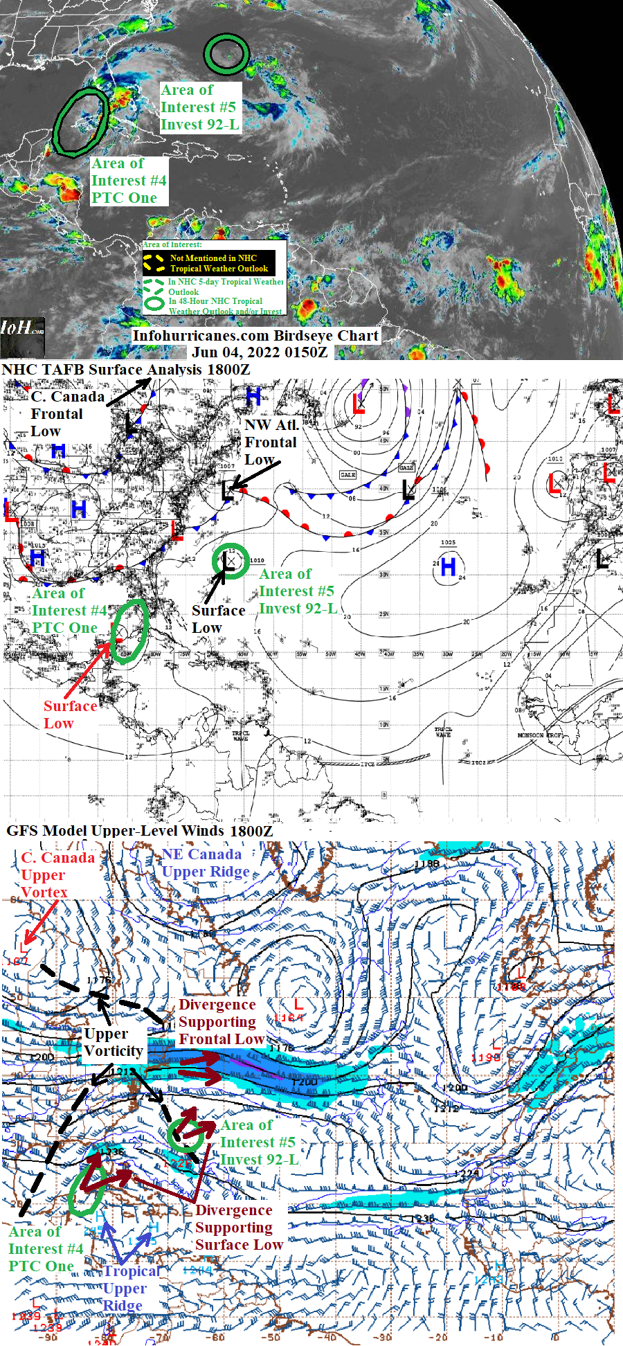
A broad tropical low pressure system in the southeastern Gulf of Mexico is expected to bring heavy weather to western Cuba… south Florida… the western Bahamas… and Bermuda in the days ahead. See area of Interest #4 section below for more details. Elsewhere… the surface trough that was northeast of the western Bahamas has redeveloped into a low pressure swirl now passing south of Bermuda… however the swirl is not expected to develop further. See area of Interest #5 section below for details.
New to this site this year… I will be sequentially numbering up areas of interest for possible Atlantic tropical development. In this scheme… will reset back to #1 at the start of next year (January 2023). The current two areas of interest in this blog post are designated #4 and #5 as I designated the first three of this year earlier this month (in previous birdseye view posts on the home page). This scheme is to reduce confusion as Atlantic tropical activity increases during the peak of the hurricane season… when multiple simultaneous areas of interest begin and end which previously required shuffling around the area of interest numbers from update to update.
AREA OF INTEREST 4 (POTENTIAL TROPICAL CYCLONE ONE)…The broad tropical low pressure system that had been near the northeast coast of the Yucatan peninsula has shifted northeastward into the southeastern Gulf of Mexico. Aircraft reconnaissance over the last several hours has found the surface circulation elongated with multiple centers and therefore this system is not a tropical cyclone by scientific definition (tropical cyclone status requires a circular circulation with single center). As a result the NHC continues designating this system as a potential tropical cyclone instead of a tropical cyclone (tropical depression or storm). The potential tropical cyclone designation allows for issuance of tropical storm warnings as this system is already capable of producing heavy rains… choppy seas… and gusty winds.
A couple of features are expected to continue steering this tropical system northeast… (1) In the high-latitudes the current northwest Atlantic frontal low is creating a surface ridge weakness helping to attract this tropical system northeastward… (2) in the low-latitudes the axis of nearby upper vorticity to the north will create a northeast push in the upper layers of the atmosphere. By 72 to 96 hours the shortwave upper trough currently over Nevada will arrive near this tropical system and re-enforce the low-latitude axis of upper vorticity. By day 4 (96 hours) the steering pattern is expected to shift as a result of the currently stalled Central Canadian upper vortex. The current frontal low below the upper vortex is decaying… however by day 4 the eastern divergence zone of the upper vortex will have birthed a new frontal cyclone whose warm sector will build an upper ridge over the northwest Atlantic. In turn the amplifying northwest Atlantic upper ridge will amplify the low-latitude upper vorticity axis… with the east side of the amplifying upper vorticity hooking the track of this tropical system more northward. Final notes regarding the track forecast … this system is currently just northwest of my previous forecast and so the updated one is adjusted accordingly. However my forecast track remains on the south side of the model spread as it will be harder for development further north due to higher levels of shear in association with the low-latitude upper vorticity axis.
As speculated in previous blog posts… it appears by the recent disorganization on satellite pictures that the nearby axis of low-latitude upper vorticity is having negative impact in two ways… (1) by producing southwesterly shearing upper-level winds pushing the strongest thunderstorms to the east of the lowest surface pressure area… (2) by having an elongated area of upper divergence which is keeping surface pressures low in an elongated area. This will make it more challenging for the surface low pressure area to become circular and establish a single center needed for tropical cyclone status. However please note that the upper divergence is also helping to gradually strengthen this system… therefore even without tropical cyclone status this system can still produce tropical storm conditions. Given the negative environment which should last for the duration of the forecast period… I have begun to lower odds of tropical cyclone formation to 75% from the previous 90% (as of 8 PM EDT the NHC tropical weather outlook odds remained elevated at 90%). These lowered odds are still elevated out of caution as many models still forecast tropical cyclone formation. As this system passes over or near Bermuda by day 4… it will be over water temps below 26 deg C and thus my tropical development odds are lowered to 0% for that timeframe. The cooler waters and ongoing upper divergence support from the upper vorticity will likely transition this system to non-tropical around this timeframe… but still capable of producing gusty winds and sea swells.
The following is the expected timing for possible gusty winds… heavy rain… and coastal sea swells:
(1) For today (Saturday): western Cuba... south Florida and the Florida Keys. Preparations should have been completed by now as the heaviest weather associated with this system has already overspread the region.
(2) For today (Saturday) and Sunday: the western Bahamas... preparations must be finished by later this morning. Heavy thunderstorm from this system are already closing in on the region which is activity sheared off of the tropical low pressure system. However stronger weather conditions may occur late today or Sunday as the axis of low surface pressure passes over… especially if the axis fires a strong thunderstorm burst.
(3) This system is expected to approach Bermuda after this weekend while still packing tropical storm force conditions. If the current forecast holds… I recommend preparations for such conditions should start on Sunday.
******Infohurricanes.com outlook. Visit hurricanes.gov (hurricanes dot gov) for official outlook***********
IOH 24 Hr Outlook (1800Z Jun 4)... 75% chance of tropical cyclone formation (south Florida near 26N-80.5W)
IOH 48 Hr Outlook (1800Z Jun 5)... 75% chance of tropical cyclone formation (northeast of the western Bahamas near 28N-77W)
IOH 72 Hr Outlook (1800Z Jun 6)... 75% chance of tropical cyclone formation (western Atlantic near 31N-71W)
IOH 96 Hr Outlook (1800Z Jun 7)… 0% chance of tropical cyclone formation (just west of Bermuda near 33N-66W)
AREA OF INTEREST 5… Satellite image of area of interest #5 re-organizing for a short time on 1700Z Friday afternoon while nearing Bermuda:

The surface trough of low pressure that was northeast of the western Bahamas has been dragged east toward Bermuda by the current northwest Atlantic frontal low. Meanwhile the low-latitude upper vorticity in the environment of this feature continued to weaken which kept shear levels low for Friday. Previously the upper vorticity capped the surface trough’s thunderstorm activity… however as the upper vorticity weakened and shrank in size it no longer completely covered the surface trough… instead the peripheral eastern divergence zone aided the surface trough and its thunderstorms. As a result this system has spun back up into a compact surface low pressure swirl and was re-introduced in the NHC tropical weather outlook. Recently as this system has moved into cooler waters below 26 deg C… the thunderstorm activity has waned. In addition wind shear is expected to ramp back up as upper vorticity ejecting from the current central Canada upper vortex moves into the western Atlantic. Therefore I do not anticipate tropical cyclone formation as this system passes just south of Bermuda over the next few hours… and plan this to be my final statement on this area of interest on this blog.
******Infohurricanes.com outlook. Visit hurricanes.gov (hurricanes dot gov) for official outlook***********
IOH 24 Hr Outlook (1800Z Jun 4)… 0% chance of tropical cyclone formation (east-southeast of Bermuda near 31N-60.5W)
...COMPUTER MODEL SUMMARY...
Source...Florida State University Experimental Forecast Tropical Cyclone Genesis Potential Fields (http://moe.met.fsu.edu/tcgengifs/)
1200Z CMC Model Run...
**For area of interest #4... a circulation center becomes better defined just offshore of the Florida peninsula west coast just offshore Port Charlotte at 24 hours… as a tropical storm departs Florida and passes just north of the western Bahamas at 48 hours…passes over Bermuda at 90 hours while becoming elongated… as a weakening remnant low drifts southeast to 30.2N-61.5W by 120 hours
**For area of interest #5... surface low crosses Bermuda at 18 hours… weakens to a trough crossing 57.5W at 48 hours
1200Z ECMWF Model Run...
**For area of interest #4... crosses the southern Florida peninsula between 24 and 48 hours as a tropical storm…while gaining strength and size passes midway between Bermuda and North Carolina at 72 hours… turns more east in track and passes just north of Bermuda between 72 and 96 hours… located at 35.5N-57.8W at 120 hours
**For area of interest #5... surface low weakens to a trough just southeast of Bermuda at 24 hours.
1800Z GFS Model Run...
**For area of interest #4… low pressure circulation remains elongated with multiple centers while moving northeast into south Florida and the Florida Straits (between Cuba and Florida) over the next 24 hours… by 33 hours one of the eastern centers strengthens into a compact tropical cyclone located just north of the western Bahamas… tropical cyclone center passes just north of Bermuda at 81 hours… afterwards drifts east to 33N-60.5W by 120 hours.
**For area of interest #5… surface low weakens to a trough just east of Bermuda at 18 hours.
1800Z NAVGEM Model Run...
** For area of interest #4… a circulation center becomes better defined when low pressure system moves across Port Charlotte Florida at 24 hours… as a tropical storm departs Florida at 36 hours…. while gaining strength and size passes midway between Bermuda and North Carolina at 72 hours… turns more east in track and passes just north of Bermuda at 90 hours… located at 35.5N-58.5W at 120 hours
**For area of interest #5... surface low weakens to a trough just east of Bermuda at 18 hours.


Comments