MY 2019 ATLANTIC HURRICANE SEASON BIRDSEYE VIEW POST #144
- NCHurricane2009

- Oct 1, 2019
- 5 min read
*******Note that forecasts and outlooks in this post are NOT the official forecast from the National Hurricane Center (NHC). They are my own detailed views on the Atlantic tropics based on current observations and latest computer model runs. As such do not make decisions based on my posts...consult news media...watches and warnings from your local weather office...and any evacuation orders issued by local governments to make the most informed and best decisions. Visit the NHC website hurricanes.gov (hurricanes dot gov) for the latest watches/warnings and official forecasts on active tropical cyclones.**********
...TUESDAY OCTOBER 1 2019 6:22 PM EDT...
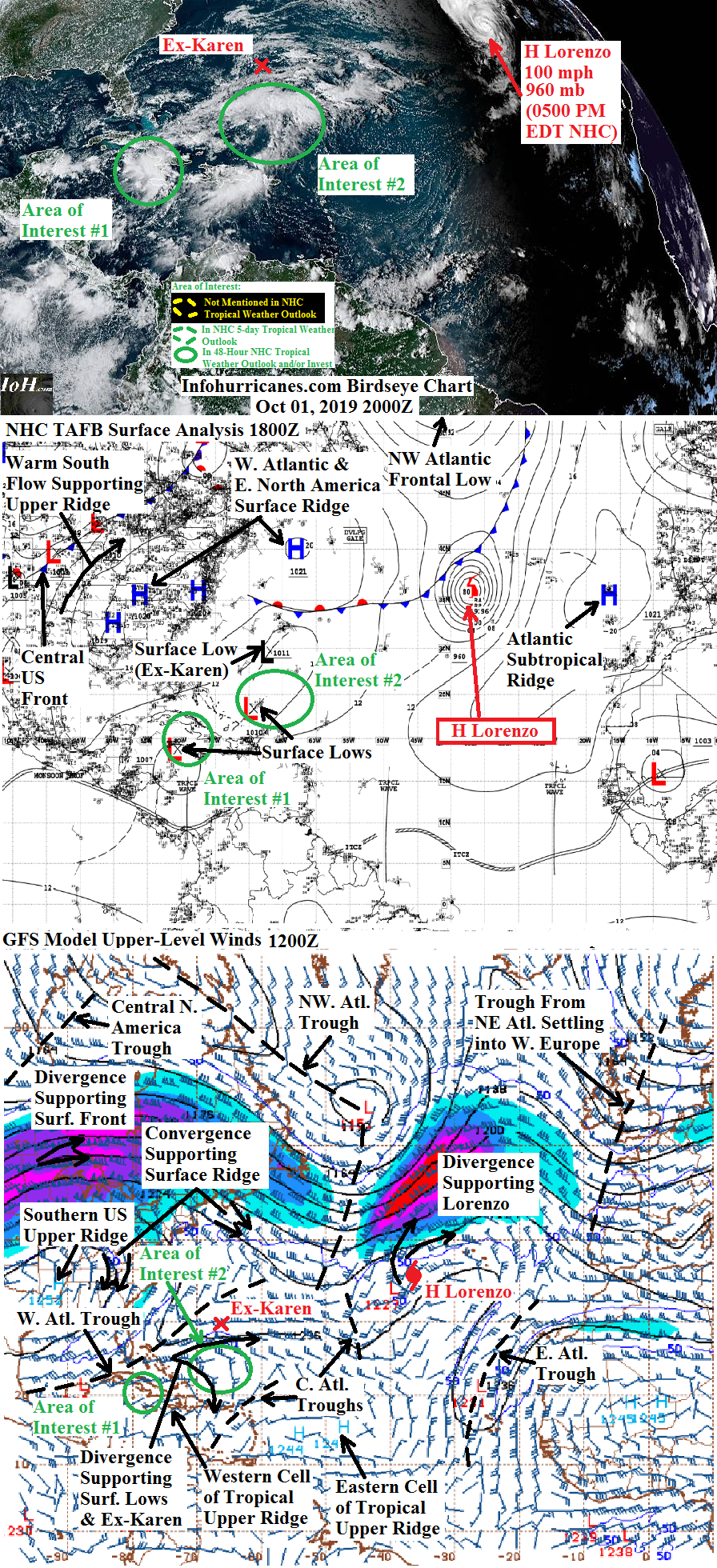
See Lorenzo section below for the only active tropical cyclone in the Atlantic basin. See area of interest sections below for areas being monitored for tropical cyclone formation. Elsewhere...the tropical wave over western Africa has seen a decrease in the concentration and organization of its thunderstorms as it moves closer to the eastern tropical Atlantic. However the Euro (ECMWF) and NAVGEM models continue suggesting this tropical wave may develop an area of low pressure as it moves into the tropical Atlantic...and upper winds will become more favorable for development in the eastern Atlantic as the current unfavorable upper trough in the area is forecast to drift northward and away in upper southwesterly flow in the wake of upper troughing scheduled to transition Lorenzo into a non-tropical gale....if this model support persists tomorrow will introduce this tropical wave as another area of interest for tropical development.
HURRICANE LORENZO...Conditions to deterorate tonight in the Azores as Hurricane Lorenzo moves northeastward toward the islands in deep-layer southwesterly flow ahead of a northwest Atlantic frontal low and its upper trough. A tremendous area of divergence on the east side of the strong upper trough is supporting Lorenzo...thus the hurricane has only weakened to 100 mph maximum sustained winds despite moving toward increasingly cooler waters. Thus my intensity forecast is nudged upward...and track forecast is nudged eastward given Lorenzo's current position. As Lorenzo moves into cool waters...merges with the cold front driven by the northwest Atlantic frontal low...all while continuing to be supported by divergence on the east side of the upper trough...Lorenzo will transition to a non-tropical frontal cyclone in the next 24 hours. The latest modeling agrees that Lorenzo's surface cold air advection on its west side will split off a portion of the upper trough into a smaller trough that shifts eastward toward the British Isles...thus it appears Lorenzo will move into the British Isles in about 72 hours (3 days). However as it makes landfall here...the small upper trough will merge with the upper trough currently settling over western Europe...leaving Lorenzo to quickly weaken under convergence on the west side of the European upper trough. Thus Lorenzo's non-tropical remnant could bring gusty winds to the British Isles...but not as severe as what will be seen tonight in parts of the Azores.
******Infohurricanes.com forecast. Visit hurricanes.gov (hurricanes dot gov) for official forecast***********
0 Hr Position (1800Z Oct 1)...100 mph maximum sustained wind hurricane centered southwest of the Azores at 37N-35.5W
IOH 24 Hr Forecast (1800Z Oct 2)...90 mph maximum susateind wind non-tropical remnant gale centered north of the Azores at 48.5N-24W
AREA OF INTEREST #1...As well-forecast by computer modeling over the last several days...a surface low pressure has formed in the northwestern Caribbean Sea thanks to supportive divergence on the east side of a western Atlantic upper trough. Currently the heaviest thunderstorm activity is sheared eastward from the lowest surface pressure by the upper trough and is located over and west of southeastern Cuba and Jamaica. In the short-term...conditions look unfavorable for tropical development due to the shear...but by 48+ hours I begin to climb the odds of tropical cyclone formation as the western Atlantic upper trough is forecast to weaken and split in half...leaving this disturbance in favorable low shear and high upper outflow between the split halves. The initial motion of this disturbance should be slow as the steering eastern US surface ridge becomes eroded by the frontal system over the central US...and will be positioned where the upper-level winds are most favorable for thunderstorm activity which I assume will be over western Cuba based on the latest GFS model upper wind forecast. After 48 hours...a surface ridge building behind the central US frontal system should steer this disturbance...likely sending the disturbance northwestward across the Gulf of Mexico around its southwest side. I drop the odds of development beginning at 120+ hours as this disturbance moves into unfavorable southwesterly shear from the western split of the current western Atlantic upper trough which will be in the western Gulf of Mexico by that time. Regardless of tropical development or not...over the next couple of days heavy rains with flash flooding are possible over western Cuba...the Cayman Islands...and if this system consolidates further south the Yucatan peninsula of southeastern Mexico. My forecast positions below are not of high confidence at this time as the surface low pressure remains broad and could consolidate in a different location...which would change the track forecast.
******Infohurricanes.com outlook. Visit hurricanes.gov (hurricanes dot gov) for official outlook***********
IOH 24 Hr Outlook (1800Z Oct 2)...0% chance of tropical cyclone formation (northwestern Caribbean in the vicnity of Cuba and the Cayman Islands)
IOH 48 Hr Outlook (1800Z Oct 3)...5% chance of tropical cyclone formation (southeastern Gulf of Mexico...northwestern Caribbean Sea...western Cuba)
IOH 72 Hr Outlook (1800Z Oct 4)...15% chance of tropical cyclone formation (southern Gulf of Mexico near 23N-87W)
IOH 96 Hr Outlook (1800Z Oct 5)...25% chance of tropical cyclone formation (Gulf of Mexico near 26.5N-91W)
IOH 120 Hr Outlook (1800Z Oct 6)...10% chance of tropical cyclone formation (coastal western Louisiana)
AREA OF INTEREST #2...Yet another broad surface low pressure has formed with the support of upper divergence on the east side of the western Atalntic upper trough...this one located well northeast of the Bahamas and north of the Caribbean islands. It appears that an arc of shower and thunderstorm activity is spread well north...east...and south of the lowest surface pressure...extending into the waters of the Mona Passage between Puerto Rico and the Dominican Republic. Warm air advection ahead of the central US frontal system is expected to amplify upper ridging over the western Atlantic and over this disturbance...which will reduce the shear imparted by the current western Atlantic upper trough and potentially allow for this disturbance to develop over the next 72 hours. Meanwhile the upper trough supporting the central US frontal system is expected to fracture into two parts...with the western trough emerging from the United States and developing a surface frontal low in the northwestern Atlantic by 72 to 96 hours. This disturbance will generally track northeast in the ridge weakness between the Atlantic subtropical ridge and eastern US surface ridge induced by the eastern split of the central US frontal upper trough...and I have peak odds of development only at 10% like the National Hurricane Center as this system will need time to consolidate to develop at all...and by 72+ hours will already be overspread by increasing southwesterly shear from the aformentioned western split of the upper trough arriving into the northwest Atlantic from the United States by that time.
******Infohurricanes.com outlook. Visit hurricanes.gov (hurricanes dot gov) for official outlook***********
IOH 24 Hr Outlook (1800Z Oct 2)...0% chance of tropical cyclone formation (western Atlantic near 25N-65W)
IOH 48 Hr Outlook (1800Z Oct 3)...5% chance of tropical cyclone formation (western Atlantic near 30N-62W)
IOH 72 Hr Outlook (1800Z Oct 4)...10% chance of tropical cyclone formation (western Atlantic near 31N-60W)
IOH 96 Hr Outlook (1800Z Oct 5)...0% chance of tropical cyclone formation (central Atlantic near 33N-54W)


Comments