MY 2025 ATLANTIC HURRICANE SEASON BIRDSEYE VIEW POST #55
- NCHurricane2009

- Aug 9, 2025
- 16 min read
*******Note that forecasts and outlooks in this post are NOT the official forecast from the National Hurricane Center (NHC). They are my own detailed views on the Atlantic tropics based on current observations and latest computer model runs. As such do not make decisions based on my posts...consult news media...watches and warnings from your local weather office...and any evacuation orders issued by local governments to make the most informed and best decisions. Visit the NHC website hurricanes.gov (hurricanes dot gov) for the latest watches/warnings and official forecasts on active tropical cyclones.*********
...FRIDAY AUGUST 8 2025 11:55 PM EDT...
Noting it has been about 48 hours since my previous update Wednesday evening due to recent activities in my personal life. I have been gradually putting this update together throughout Friday... with the above birdseye view satellite image... surface chart... and upper air chart put together early Friday. The text and forecasts below were then completed by 11:55 PM EDT Friday based on satellite observations through 0000Z.
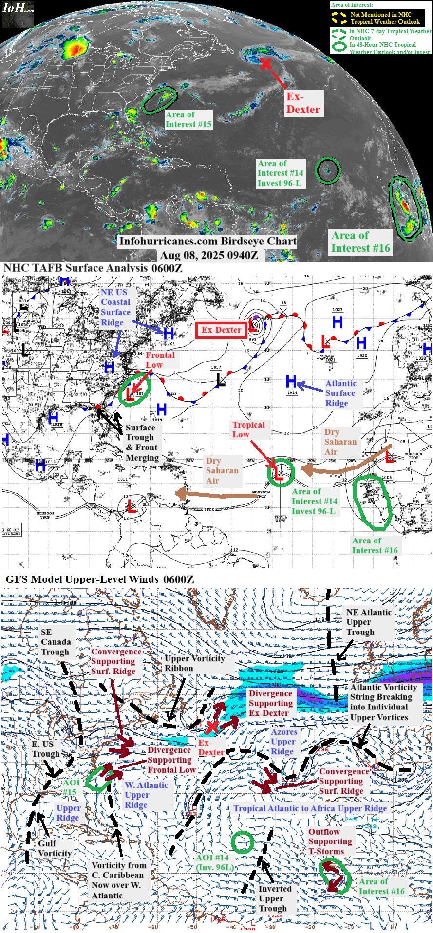
In the wake of what was tropical cyclone Dexter in the north Atlantic... the Atlantic tropics are busy with three concurrent areas of interest:
(1) Still monitoring a frontal low currently east of North Carolina for possible tropical development... see area of interest #15 section below for details.
(2) A tropical wave of low pressure has organized into a small tropical low pressure spin now moving west-northwest across the open central Atlantic... this system continues to be monitored for signs of additional development... see area of interest #14 section below for more information.
(3) The large tropical wave of low pressure currently emerging from western Africa has been upgraded to an area of interest by the National Hurricane Center... see area of interest #16 section below for details.
Elsewhere in the Atlantic basin... noting a band of low-level vorticity (spin) extends southwest from area of interest #15 to the Florida peninsula from the merger between a surface front that was over the southeastern United States and surface trough that was approaching from the Bahamas. The band of low-level vorticity will likely be downgraded soon from a frontal boundary to a surface trough due to loss of airmass contrasts across it... and the surface trough will spend the next 48 hours drifting northwest across the eastern Gulf of America before it makes landfall on the eastern United States Gulf coast as it rounds the steering northeastern US coastal surface ridge which settles into the western Atlantic. The current upper ridge cell in the region also remains in place which keeps shear low and upper outflow potential high... in fact the upper outflow had aided in a round of enhanced thunderstorms across the Florida peninsula and northwestern Bahamas late Friday. Although computer models do not currently develop this system... if satellite observations warrant the surface trough could later be upgraded to an area of interest for the eastern Gulf of America and eastern part of the US Gulf coast.
REMNANTS OF DEXTER... While zooming east-northeast well offshore of Atlantic Canada the National Hurricane Center issued their final advisory on Dexter at 11 AM EDT Thursday while declaring the transition from tropical storm to power non-tropical frontal cyclone was complete. The transition was aided by decreasing sea-surface temps along the track and as Dexter's northwest quadrant pulled in cooler air associated with the nearby east-west upper vorticity ribbon... resulting in a supporting cool core upper trough where the flow around its east side is divergent and re-enforcing the intensity of ex-Dexter's surface low pressure field (noting the remainder of the ribbon is further west over southeast Canada where it is merging with the upper trough that recently moved into that area). Models going forward agree on ex-Dexter decaying as classical post-mature frontal cyclone while passing north of the Azores and approaching Europe... as it whirls beneath the core of its supporting upper trough where upper divergence is lacking. This is the final statement on Dexter on this blog as it is no longer a tropical system.
AREA OF INTEREST #14... Satellite image of tropical low at is peak organization in recent hours... as of 1940Z Friday August 8:
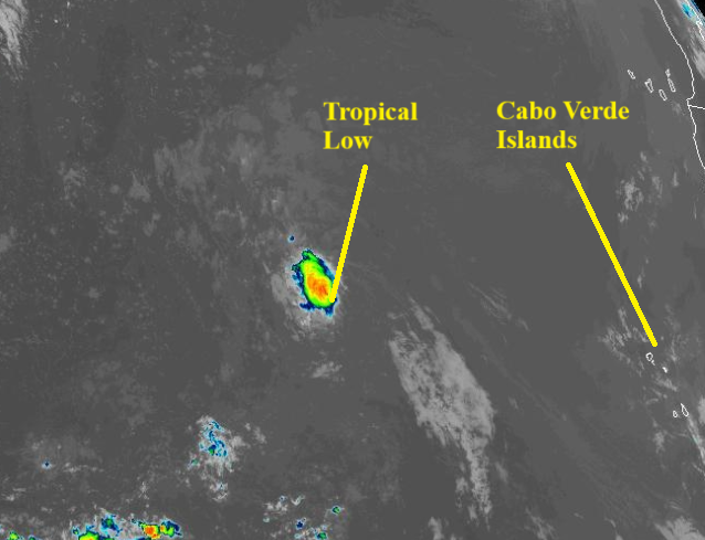
The eastern Atlantic tropical wave of low pressure that the National Hurricane Center has been monitoring over the last few days has proceeded into the central tropical Atlantic. Since Wednesday the wave of interest appears to have merged with an adjacent wave to the west to effectively make a southwest to northeast tilted surface trough as the wave of interest began to deviate north in the low-level cyclonic flow associated with the adjacent wave to the west. Meanwhile the adjacent wave to the east has not merged with the southwest to northeast surface trough... the CIMSS 850 mb vorticity product shows that the spin of that wave is southwest of the Republic of Cabo Verde Islands and will soon be absorbed by what is tagged as area of interest #16 in this blog post (https://tropic.ssec.wisc.edu/real-time/windmain.php?basin=atlantic&sat=wg8&prod=vor&zoom=&time=). Going back to the tropical wave of interest... since Wednesday what was left of the wave's vorticity appeared to become a southwest-northeast oblong tropical low located at the northeast end of the lengthy surface trough. For much of Thursday the northwest moving tropical low moved into the regional dry Saharan air layer and proceeded to lose thunderstorms. However as of this past afternoon and evening the tropical low has made strides in becoming better organized while finding a break in the dry air... between a band of dry Saharan air to the southwest and a surge of dry air to the east based on using beige tinting in true-color visible satellite to locate the dry Saharan air before sunset. Specifically... the tropical low has become more compact and circular and is firing a persistent circular thunderstorm canopy.
Track forecast... as of 0000Z tonight the tropical low was centered at 18.8N-43.5W and was deflecting more west and less north in track while bumping into the steering Atlantic surface ridge. The more north initial position closer to the steering ridge results in a faster forward speed... and my updated forecast track is updated to be more aligned with the short-term model consensus which had a faster speed. Noting that other than the GFS the models do not develop this system... perhaps while being incorrectly initialized with a tropical wave/ inverted surface trough instead of a tropical low. This becomes important in the track forecast as the first opportunity for a northward turn is if this system re-forms due to the pressure-dropping eastern divergence zone of the current mid-ocean upper vortex near 28N-50W... something that occurs more easily if this system is an open tropical wave/ surface trough instead of a well-defined tropical low. The CMC and GFS model runs published in the computer model summary section below show such an early northward turn... the difference is the CMC doesn't develop this system while the GFS does in the long range after day 5. For now I prefer to not show the early northward turn and keep this system moving west-northwest... something that is helped by a western Atlantic surface ridge to be supported by the western convergence zone of the upper vortex that will be on top of area of interest (AOI) #15. However I do slow the forward speed to acknowledge the ridge weakness between the western and eastern Atlantic surface ridges to be induced by the pressure drops associated with the divergence zone of the mid-ocean upper vortex and presence of AOI #15. By day 5 I show a north turn into the waters southeast of Bermuda as the western Atlantic surface ridge begins to fade due to the approach of a large-scale frontal system from eastern Canada and northeastern US. The warm sector upper ridge associated with the frontal system forces the upper vortex over AOI #15 to become an elongated north-south upper trough... with the south base of the upper trough digging toward this area of interest. As a result this area of interest could already be tracking straight north on day 5 despite the western Atlantic surface ridge not yet fully dissipating... while transitioning into a feature supported by the eastern divergence zone of the upper trough.
Probabilities of tropical cyclone formation... During the forecast period the cold core mid-ocean upper vortex near 28N-50W continuously shrinks from prolonged isolation from high-latitude cold air... and also drifts north at first while gravitated to the upper trough tied to ex-Dexter then while gravitated to the southeast quadrant of the upper vortex to be positioned over AOI #15. This allows the tropical Atlantic upper ridge that has been expanding from the southeast to bridge with the mid-latitude western Atlantic upper ridge cell to the northwest... creating a vast area of low shear and upper outflow potential along the forecast track of this area of interest. Noting a part of the materializing vast upper ridge has weakened along 30W longitude as the Azores upper ridge cell currently supported by the warm southerly flow ahead of ex-Dexter is pushing an upper vortex southeast of the Azores into the upper ridge. As a result an inverted upper trough has materialized on the south side of the weakened part of the upper ridge and along 35W longitude... and this inverted upper trough will chase this area of interest. However the updated forecast track for this area of interest is fast enough that the inverted upper trough is not expected to catch up to it. By day 5 the mid-latitude upper trough that digs south toward this area of interest may be amplified enough to mitigate westerly shear... instead the upper trough may be beneficial with its supportive eastern divergence zone. The favorable upper wind outlook through day 5 and recent organization trends of this area of interest cause me to raise peak odds of tropical cyclone formation to above 50%... however I have not gone higher than 60% in this update cycle while waiting to see if it retains its current organization for 24 more hours and waiting to see if model support showing development increases. In the short-term I keep odds at a lower 50% as the tropical low of interest has a small rather than large thunderstorm canopy still making it susceptible to ingesting dry Saharan air and as the fast forward motion may make it difficult for the south side of the circulation to be closed off. The higher odds for the longer range are then supported by a slower forward speed in that part of the forecast track and as this system moves further away from the dry Saharan air layer.
Regarding impact to land areas... notable impacts to the northern Lesser Antilles are unlikely as the forecast track has shifted away from the region. It is too early to know exactly when the north turn of this system will occur... a later northward turn and development into a tropical cyclone would increase the potential for surf reaching the shores of Bermuda by Wednesday and Thursday.
******Infohurricanes.com outlook. Visit hurricanes.gov (hurricanes dot gov) for official outlook***********
IOH 24 Hr Outlook (0000Z Aug 10)... 50% chance of tropical cyclone formation (central tropical Atlantic near 20.5N-50W)
IOH 48 Hr Outlook (0000Z Aug 11)... 60% chance of tropical cyclone formation (central Atlantic near 22.5N-55.5W)
IOH 72 Hr Outlook (0000Z Aug 12)... 60% chance of tropical cyclone formation (central Atlantic near 24N-59.5W)
IOH 96 Hr Outlook (0000Z Aug 13)... 60% chance of tropical cyclone formation (southeast of Bermuda near 26N-61.5W)
IOH 120 Hr Outlook (0000Z Aug 14)... 60% chance of tropical cyclone formation (southeast of Bermuda near 30N-62W)
*****National Hurricane Center (hurricanes.gov) official outlook as of 8 PM EDT***********************
Formation chance through 48 hours... 0%
Formation chance through 7 days... 40%
AREA OF INTEREST #15... Satellite image as of 2101Z Friday August 8 of the area of disturbed weather offshore of the southeastern United States consisting of a surface trough of low pressure that has materialized from the merger of features in the region. The surface trough axis is marked with a red-dashed line:
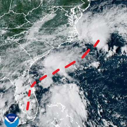
Evolution of this area of interest since previous update on Wednesday... offshore of the southeastern United States a surface low near 31N-75W became defined along the surface front trailing from what is now ex-Dexter. Since then the frontal low drifted west a little closer to the southeastern United States coast under the influence of the surface ridge that has settled along the northeastern United States coast... then over the last several hours has reversed to an east-northeast course while transitioning into a feature supported by the divergence zone of the incoming upper trough from southeastern Canada. Although the frontal low initially featured thunderstorms in its western semicircle on Wednesday... the activity did not persist. It is probable this is due to the upper vorticity that was over the central Caribbean moving northwest toward the frontal low while gravitated toward the southeast Canada upper trough... thus leaving little room for thunderstorm-inducing upper outflow between the approaching upper vorticity from the southeast and the upper trough to the northwest. Further south a surface trough formed north of the northeastern Caribbean Islands late Sunday/ early Monday as noted in full update #52 (https://www.infohurricanes.com/post/my-2025-atlantic-hurricane-season-birdseye-view-post-52)... the surface trough since then continued across the Bahamas and then became attached to the frontal low of interest while gravitated to the frontal low. And to the southwest... the east-west segment of surface frontal boundary over the southeastern US has taken an increasing southwest northeast orientation while becoming a feature maintained by the southeastern divergence zone of the weak upper trough that has been over the eastern US. Recently the frontal low of interest... the surface trough attached to the south... and surface front to the southwest have merged into a southwest to northeast tilted surface trough offshore of the southeastern United States. The frontal low at the northeast end of the surface trough... positioned east of North Carolina as of this update... remains the focus of this area of interest. The above intro section of this update meanwhile has remarks on the rest of the surface trough which may become another area of interest in the eastern Gulf of America.
Forecast for the frontal low of interest and supporting upper trough incoming from southeast Canada... the upper trough is expected to amplify into a cut-off upper vortex due to an amplifying upstream warm core upper ridge induced by the warm southwesterly flow ahead of a large-scale frontal system developing over Canada. The latest model consensus has the surface frontal low arcing ahead of the amplifying upper trough/ vortex instead of immediately whirling beneath the core of the upper vortex... and the updated forecast track below is adjusted accordingly. As such if tropical development were to occur... it would more likely be a tropical system ahead of the upper vortex than a subtropical system under the vortex... and my designations in the updated outlook below have been changed from subtropical to tropical. This past 1800Z GFS model run still suggested a respectable surface low with well-defined rather than oblong center while still over waters at least 26 deg C... and the combo of low enough shear and upper divergence ahead of the amplifying upper trough may help with thunderstorm and tropical development. Therefore I hang on to the frontal low as an area of interest... but still with a low 20% chance of tropical cyclone formation as the GFS was an exception rather than the consensus among the family of global models. Meanwhile the NHC is preparing to drop this area of interest while dropping odds to 0% in their 8 PM EDT tropical weather outlook. Noting from 48 to 72 hours the frontal low of interest proceeds to whirl northwest into the northeast quadrant of the upper vortex... reaching waters below 26 deg C and the upper vortex is not particularly cold enough to support instability and thunderstorms over waters below 26 deg C... therefore I drop my tropical development odds to 0% by then.
Regarding impact to land areas:
(1) Due to the eastward shifted forecast track... the potential for surf along the mid-Atlantic and northeastern US coast from this feature has ended.
(2) The 72-hour (late Monday/ early Tuesday) forecast point is still close to the Nova Scotia coast... this system may therefore produce surf reaching the Nova Scotia coast should it gain sufficient strength.
******Infohurricanes.com outlook. Visit hurricanes.gov (hurricanes dot gov) for official outlook***********
IOH 24 Hr Outlook (0000Z Aug 10)... 0% chance of tropical cyclone formation (northwestern Atlantic near 36.5N-66W)
IOH 48 Hr Outlook (0000Z Aug 11)... 20% chance of tropical cyclone formation (northwestern Atlantic near 38.5N-60.5W)
IOH 72 Hr Outlook (0000Z Aug 12)... 0% chance of tropical cyclone formation (south-southeast of Nova Scotia near 41.5N-60.5W)
*****National Hurricane Center (hurricanes.gov) official outlook as of 8 PM EDT***********************
Formation chance through 48 hours... 0%
Formation chance through 7 days... 0%
AREA OF INTEREST #16... More recent satellite image of tropical wave emerging from western Africa as of 2200Z Friday August 8:
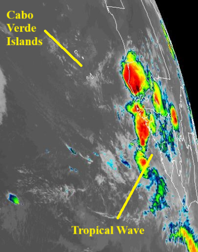
A large tropical wave of low pressure is currently entering the eastern tropical Atlantic from the west coast of Africa. I agree with the National Hurricane Center (NHC) recently introducing this feature as an area of interest for possible tropical development as the wave has seen an increase in thunderstorms for much of Friday and to the south of a recent surge of dry Saharan air... and would have done so in this update if the NHC hadn't. Per the computer model summary section below... the GFS and ECMWF are coming on board for developing this tropical wave as it continues west-northwest across the Atlantic tropics while steered by the Atlantic surface ridge. The models have recently trended with this wave retaining its identity instead of degenerating into a southwest-northeast surface trough entangled with the next large wave forecast to emerge from Africa which help's this wave's chances for development. However not agreeing with this past 1800Z GFS model run which showed rapid development as large/ broad systems such as this wave take time to develop a well-defined center... and the broadness of this wave will be re-enforced by it absorbing a currently inactive wave southwest of the Republic of Cabo Verde Islands as noted in the above area of interest #14 discussion. As such agreeing with the NHC's strategy of gradually ramping odds of tropical cyclone formation to 20%... and will issue higher odds in future updates should this wave avoid ingesting dry Saharan air and become better organized.
******Infohurricanes.com outlook. Visit hurricanes.gov (hurricanes dot gov) for official outlook***********
IOH 24 Hr Outlook (0000Z Aug 10)... 0% chance of tropical cyclone formation (eastern tropical Atlantic near 9N-19W)
IOH 48 Hr Outlook (0000Z Aug 11)... 10% chance of tropical cyclone formation (eastern tropical Atlantic near 10N-24W)
IOH 72 Hr Outlook (0000Z Aug 12)... 10% chance of tropical cyclone formation (eastern tropical Atlantic near 11N-29W)
IOH 96 Hr Outlook (0000Z Aug 13)... 15% chance of tropical cyclone formation (eastern tropical Atlantic near 11.5N-34W)
IOH 120 Hr Outlook (0000Z Aug 14)... 20% chance of tropical cyclone formation (eastern tropical Atlantic near 12N-39.5W)
*****National Hurricane Center (hurricanes.gov) official outlook as of 8 PM EDT***********************
Formation chance through 48 hours... 0%
Formation chance through 7 days... 20%
...COMPUTER MODEL SUMMARY...
Source...Florida State University Experimental Forecast Tropical Cyclone Genesis Potential Fields (http://moe.met.fsu.edu/tcgengifs/).
1200Z (Aug 8) CMC Model Run...
**For area of interest #14... Initialized as a tropical wave instead of tropical low and no development shown
**For area of interest #15... northeast end of surface trough spanning from Florida to waters offshore of southeastern US continues east-northeast and becomes a broad surface low supported by approaching upper trough from SE Canada and positioned north of Bermuda by 42 hours... surface low becomes generally quasi-stationary at this location through 72 hours while trapped between Atlantic surface ridge to the east and developing deep-layer ridge to the west with the supporting upper trough to the northwest also becoming a cut-off upper vortex also stuck between the ridges... the cut-off upper vortex and surface low increasingly move north-northeast as approaching large-scale Canadian upper trough and its surface frontal system erode the western ridge and the surface low reaches a position south-southwest of Newfoundland at 138 hours... while moving northeast across southeast Newfoundland
**For area of interest #16... large tropical wave currently emerging from western Africa moves into the waters just south of the Republic of Cabo Verde islands through 42 hours while becoming a large tropical low... while reaching 45W longitude at 126 hours the large tropical low re-opens to a wave and does not re-develop in the longer range
**Additional tropical wave emerges from west coast of Africa at 96 hours... through 126 hours transitions into a southwest-northeast tilted surface trough straddling the Republic of Cabo Verde Islands due to close proximity of additional tropical wave to the east... the surface trough proceeds to become an oblong southwest-northeast tropical low at a position WSW of the Republic of Cabo Verde Islands through 168 hours
0000Z (Aug 8) ECMWF Model Run...
**For area of interest #14... Initialized as a tropical wave instead of tropical low and no development shown
**For area of interest #15... northeast end of surface trough spanning from Florida to waters offshore of southeastern US continues east-northeast and becomes a broad surface low supported by approaching upper trough from SE Canada and positioned north-northwest of Bermuda by 48 hours... without tropical development the surface low continues east-northeast then turns increasingly north toward Newfoundland by 120 hours while bumping into Atlantic surface ridge to the east (data after 120 hours for this model run not available at above-mentioned source)
**For area of interest #16... large tropical wave currently emerging from western Africa moves into the waters just south of the Republic of Cabo Verde islands through 54 hours while becoming a large tropical low... large tropical low nears 40W longitude at 120 hours (data after 120 hours for this model run not available at above-mentioned source)
1200Z (Aug 8) ECMWF Model Run...
**For area of interest #14... same as 0000Z Aug 8 ECMWF run before 120 hours... no development shown after 120 hours
**For area of interest #15... same as 0000Z Aug 8 ECMWF run before 120 hours... after that time moves northeast into Newfoundland where it loses identity to large low pressure field associated with incoming Canadian frontal system
**For area of interest #16... same as 0000Z Aug 8 ECMWF run before 120 hours... after that time proceeds to become a large tropical cyclone east-northeast of the Lesser Antilles by 168 hours
1800Z (Aug 8) GFS Model Run...
**For area of interest #14... Initialized as a tropical wave instead of tropical low with the wave turning increasingly north toward the ridge weakness associated with area of interest (AOI) #15... north apex of wave develops into a tropical low near 30N-52.5W at 72 hours... while rounding the west side of the Atlantic surface ridge the tropical low proceeds to continue north and becomes a tropical cyclone near 34.8N-53.5W at 132 hours... to the northwest the upper vortex over AOI #15 elongates into an upper trough while AOI #15 is absorbed by large surface frontal system departing Canada and the tropical cyclone turns northeast in the deep-layer southwesterly flow ahead of all of these features and reaches 40N-48.8W at 168 hours
**For area of interest #15... northeast end of surface trough spanning from Florida to waters offshore of southeastern US continues east-northeast and becomes a broad surface low supported by approaching upper trough from SE Canada and positioned northwest of Bermuda by 21 hours... surface low strengthens while moving northeast to 40N-60W through 54 hours as the supporting upper trough to the northwest amplifies into a cut-off upper vortex which increases the divergence over the surface low with tropical development possible around that time while still over 26 deg C water and as the more divergent upper flow is also less shearing... through 93 hours the surface low weakens while whirling northwest into northeast quadrant of upper vortex and closer to Nova Scotia where water temps are cooler and upper divergence is less... while drifting northeast to eastern tip of Nova Scotia through 114 hours loses identity to large surface low pressure field of incoming frontal system approaching from Canada
**For area of interest #16... within southeast side of large tropical wave currently emerging from western Africa rapid compact tropical cyclone formation suggested just offshore of Guinea-Bissau over next 24 hours... while orbiting remainder western part of the large tropical wave the compact and strengthening tropical cyclone moves northwest into the southern Republic of Cabo Verde Islands through 48 hours... proceeds west-northwest away from the Republic of Cabo Verde Islands and across the Atlantic while becoming a hurricane and reaches 22.5N-57.5W (well northeast of the Lesser Antilles) as a potentially intense hurricane
**Large tropical wave emerges from west coast of Africa at 93 hours and proceeds to become a broad tropical low just southwest of the Republic of Cabo Verde Islands at 126 hours... proceeds to open back to a wave through 168 hours while crossing 40W longitude
1800Z (Aug 8) NAVGEM Model Run...
**For area of interest #14... Initialized as a tropical wave instead of tropical low and no development shown
**For area of interest #15... northeast end of surface trough spanning from Florida to waters offshore of southeastern US continues east-northeast and becomes a broad surface low supported by approaching upper trough from SE Canada and positioned near 38.8N-63.8W at 30 hours... while moving east-northeast into open northwest Atlantic proceeds to become a multi-center SW/NE elongated surface low through 96 hours which then degenerates into a SW/NE surface trough by 120 hours... through 156 hours the surface trough loses identity to large low pressure field of approaching Canadian frontal system
**For area of interest #16... large tropical wave currently emerging from western Africa moves into the waters southwest of the Republic of Cabo Verde islands through 36 hours while becoming a large tropical low... centroid of large tropical low positioned well east of the northern Lesser Antilles and near 16N-55W at 168 hours
**Large tropical wave emerges from west coast of Africa at 108 hours and becomes a large tropical low while moving over the Republic of Cabo Verde Islands through 168 hours


Comments