MY 2025 ATLANTIC HURRICANE SEASON BIRDSEYE VIEW POST #54
- NCHurricane2009

- Aug 6, 2025
- 18 min read
*******Note that forecasts and outlooks in this post are NOT the official forecast from the National Hurricane Center (NHC). They are my own detailed views on the Atlantic tropics based on current observations and latest computer model runs. As such do not make decisions based on my posts...consult news media...watches and warnings from your local weather office...and any evacuation orders issued by local governments to make the most informed and best decisions. Visit the NHC website hurricanes.gov (hurricanes dot gov) for the latest watches/warnings and official forecasts on active tropical cyclones.*********
...WEDNESDAY AUGUST 6 2025 8:40 PM EDT...

Tropical activity remains elevated across the Atlantic basin with one active tropical storm and two concurrent areas of interest as follows:
(1) Tropical Storm Dexter continues east-northeast across the open northwest Atlantic... see Dexter section below for more details on the storm.
(2) The segment of frontal boundary currently offshore of the southeastern United States has evolved into a surface low near 31N-75W being monitored for tropical development... the forecast track has shifted north to now be parallel to the United States east coast and Nova Scotia due to the initial position of this feature... see area of interest #15 section below for details.
(3) The National Hurricane Center is monitoring the tropical wave of low pressure currently over the eastern tropical Atlantic for signs of development... see area of interest #14 section below for more information.
Elsewhere in the Atlantic basin... noting the following:
(1) The surface trough of low pressure over the Bahamas is becoming entangled with area of interest #15 offshore of the southeastern United States... if it continues to persist it will simply merge with the area of interest.
(2) Over the next week... another lengthy tropical disturbance similar to area of interest #14 may emerge from Africa to the central tropical Atlantic from the merger among a series of large tropical waves of low pressure forecast to emerge from the west coast of Africa... the first of these large waves is scheduled to depart Africa in about 2 to 3 days per the latest model consensus. The sprawling nature of such a disturbance may cause it to ingest dry Saharan air... however if a smaller circulation develops within and far enough away from dry Saharan air it could become a new area of interest for tropical development in future updates.
TROPICAL STORM DEXTER... The tropical storm in the northwestern Atlantic is interacting with a complex upper trough emerging from eastern North America. The upper trough is in the process of splitting into three pieces... one to move into the far northeast corner of the Atlantic... another an east-west ribbon of upper vorticity to settle across the northwest Atlantic... and a weak upper trough stalled over the eastern US. The tropical storm has lifted northeast of my previous forecast track in the last 36 hours while attracted to surface pressure falls associated with the divergent upper westerly jet between the north side of the mid-latitude Atlantic upper ridge and south of the emerging northwest Atlantic upper vorticity ribbon. As such the models have converged on Dexter continuing east-northeast out to sea while caught in the deep-layer ridge weakness associated with the upper vorticity ribbon and remainder eastern part of the surface front from which Dexter was born from which will be maintained by the aforementioned divergent upper westerly jet... and my updated forecast track below is adjusted accordingly. Regarding strength... Dexter has gradually intensified today despite its thunderstorm canopy remaining sheared to the east of center due to the divergent nature of the upper winds within the jet that Dexter has arrived to... with the upper divergence helping to drop Dexter's surface pressure. The thunderstorm canopy may also be contributing to increasing the local-scale upper divergence through latent heat release creating warming and a rise in upper-level pressures that force the upper wind vectors to be more divergent. Going forward transition into a strong non-tropical frontal cyclone is expected due to decreasing sea-surface temps along the forecast track and as Dexter's northwest quadrant pulls in cooler air associated with the upper vorticity ribbon... resulting in a supporting cool core upper trough where the flow around its east side is more divergent than the current westerly jet configuration... with ex-Dexter of course taking advantage of that divergence. In the next 24 hours Dexter is expected to reach peak strength during the transition process... and currently forecasting that Dexter will not have quiet completed the transition at the 24 hour point while having just entered waters below 26 deg C. The peak strength has potential to be aided by thunderstorm latent heat release as mentioned above... and the NHC has progressively increased the peak intensity forecast by first calling for 60 mph maximum sustained winds in their 11 PM EDT advisory last night then 70 mph maximum sustained winds for this past 11 AM EDT advisory (as of the most recent 5 PM EDT advisory the NHC peak forecast is still 70 mph). Due to the recent lowering of the thunderstorm canopy intensity (on infrared satellite) between 12Z and 18Z I have gone with the lower 60 mph peak intensity forecast in this update. Noting for the long range the models generally agree on ex-Dexter decaying as classical post-mature frontal cyclone at a position north of the Azores... as it whirls beneath the core of its supporting upper trough where upper divergence is lacking.
******Infohurricanes.com forecast. Visit hurricanes.gov (hurricanes dot gov) for official forecast*********
0 Hr Position (1800Z Aug 6)... 50 mph maximum sustained wind tropical storm centered in the northwest Atlantic at 40N-58W
IOH 24 Hr Forecast (1800Z Aug 7)... 60 mph maximum sustained tropical storm centered in the north Atlantic at 41.2N-49W
IOH 48 Hr Forecast (1800Z Aug 8)... Remnant frontal cyclone centered in the north Atlantic at 43N-42W
*****National Hurricane Center (hurricanes.gov) official forecast as of 11 AM EDT***********************
Peak Strength (0000Z Aug 8)... 70 mph maximum sustained wind tropical storm transitioning into a remnant frontal cyclone in the north Atlantic while centered at 42.9N-47.3W
4-Day Position (1200Z Aug 10)... 40 mph maximum sustained wind dissipating non-tropical frontal low centered north-northeast of the Azores at 47N-26.2W
AREA OF INTEREST #14... The tropical wave of low pressure in the eastern tropical Atlantic that the National Hurricane Center has been monitoring now appears to be part of a trio of closely-spaced waves spanning the central and eastern tropical Atlantic... with one to the west that emerged from Africa earlier on August 1 and another to the east which has emerged from Africa in the last 36 hours. The proximity of the waves has allowed them to interact with each other where the westernmost wave in the chain deviates south due to the cyclonic flow of neighboring one to the east... and the easternmost wave having the tendency to deviate north due to the cyclonic flow of the neighboring one to the west. The end result is effectively a lengthy surface trough of low pressure from western Africa to the central tropical Atlantic with the tilt of the surface trough axis undergoing cyclonic rotation and hence becoming increasingly oriented southwest to northeast. The increased thunderstorm activity seen along 10N latitude in the Atlantic tropics over the last day or so was potentially triggered by the southwestern tail of the lengthy surface trough (and its associated surface convergence) dipping south away from the dry Saharan air while at the same time taking advantage of the broad upper anticyclonic outflow in the region. Overnight it seemed a small rotation at the southwestern tail of the surface trough and near 10N-44W was the most interesting feature... however as of this afternoon and through sunset as the rotation nears 10N-50W it appears the swirl center has ingested dry Saharan air with the pockets of thunderstorms now west of center and hence I have not upgraded it to an area of interest. Meanwhile this area of interest continues to be defined by the tropical wave axis the NHC has been monitoring... with the wave axis arriving to 35W longitude as of this writing. The thunderstorm activity of the wave has become a little better organized today and satellite imagery suggests the spin maximum of the wave is near 10.5N-35W. The CIMSS 850 mb vorticity product (https://tropic.ssec.wisc.edu/real-time/windmain.php?basin=atlantic&sat=wg8&prod=vor&zoom=&time=) suggests the spin is oblong southwest-to-northeast with two spin maximums... and as of late it appears the thunderstorms are congregating around the northeastern maximum.
For the forecast... model runs have the same general story of a spin maximum emerging somewhere along the lengthy surface trough axis that the aforementioned tropical wave trio has resulted in... with the spin maximum taking an initial cyclonic arc (north trajectory then west trajectory) as the surface trough tilt is rotating cyclonically as noted in the previous paragraph. For now my short-term forecast track has a smaller radius arc than this past 0600Z GFS run as I give more credence to the centroid of the oblong spin at 10N-35W instead of the CIMSS 850 mb northeastern maximum contained within the oblong spin as the GFS might be doing... albeit in my forecast track I assume some northeastward reformation of the centroid given the thunderstorms are congregating around the CIMSS 850 mb northeastern maximum. In the medium range and through day 5 the models have a mostly west track but with a north slant due to the weakened west side of the steering Atlantic surface ridge caused by the remnant non-tropical cyclone of Dexter and western Atlantic low pressure system currently being tagged as area of interest #15 in this blog. Also noting the current Atlantic upper vorticity string weakens and breaks up from its isolation with high-latitude cold air... with a piece of the decay becoming a mid-ocean upper vortex whose eastern divergence zone may contribute to the weakened west side of the steering surface ridge. Starting out with slightly higher 20% odds of tropical cyclone formation in the next 24 hours due to the recent improvement in the organization of the thunderstorms... then drop odds back to 10% as the forecast track has this system traverse west-northwest through the dry Saharan air. The models also tell a story of possible short-term development then medium range weakening (days 2 to 5) perhaps from the dry air. In the long range (days 5 to 7) the models have this system turn north into the western Atlantic ridge weakness where the models re-develop this system perhaps while now past the dry air zone. This long range projection of more favorable conditions is currently outside my 5-day outlook range... however by tomorrow the window of more favorable conditions will be within the 5-day range and I expect to be issuing higher development odds in the next update. Noting the NHC outlook's range is 7 days and hence they are broadcasting higher development odds of 60% as a result.
As if this forecast isn't complicated enough... the 0600Z GFS suggests the warm southerly flow ahead of of ex-Dexter will inflame the mid-latitude Atlantic upper ridging enough to push some of the current Atlantic upper vorticity string toward the Atlantic tropics... resulting in a weakened tropical Atlantic upper ridge. An inverted upper trough results on the south side of the weakened part of the upper ridge which then proceeds west toward this area of interest. If the inverted upper trough catches up it could cap the upper outflow potential that this area of interest would need for development. If this area of interest takes a larger radius cyclonic turn in the short-term... it would be further north and closer to the steering Atlantic surface ridge which would help it move faster and outrun the chasing inverted upper trough in the 2 to 5 day window.
Regarding impact to land areas... the models develop this system in the long range (5 to 7 days) after it turs north away from the northern Lesser Antilles islands. Therefore it is unlikely this area of interest brings notable impacts to these islands.
******Infohurricanes.com outlook. Visit hurricanes.gov (hurricanes dot gov) for official outlook***********
IOH 24 Hr Outlook (1800Z Aug 7)... 20% chance of tropical cyclone formation (eastern tropical Atlantic near 12N-38W)
IOH 48 Hr Outlook (1800Z Aug 8)... 10% chance of tropical cyclone formation (central tropical Atlantic near 14.5N-41W)
IOH 72 Hr Outlook (1800Z Aug 9)... 10% chance of tropical cyclone formation (central tropical Atlantic near 16N-46.5W)
IOH 96 Hr Outlook (1800Z Aug 10)... 10% chance of tropical cyclone formation (central tropical Atlantic near 17N-52.5W)
IOH 120 Hr Outlook (1800Z Aug 11)... 10% chance of tropical cyclone formation (east-northeast of the northern Lesser Antilles islands near 18.5N-59W)
*****National Hurricane Center (hurricanes.gov) official outlook as of 8 PM EDT***********************
Formation chance through 48 hours... 30%
Formation chance through 7 days... 60%
AREA OF INTEREST #15... Recent visible satellite image as of 2130Z of surface low becoming better defined near 31N-75W... the center of circulation is marked by red crosshairs:
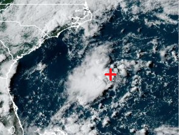
A surface low pressure has become increasingly defined along the surface front trailing from Tropical Storm Dexter... at a position offshore of the southeastern United States and near 31N-75W. This is northeast of the previous forecast as was previously anticipating the western divergence zone of what is now the current central Caribbean inverted upper trough to trigger the frontal low. The small shift in the initial position of the frontal low has created a large shift in the long-range forecast track. Previously was expecting the currently building southeast Canada surface ridge to push this system into the southeast US coast. Instead the initial position makes the frontal low more prone to being tugged by the surface ridge weakness to the northeast associated with the remainder of the front and Dexter... hence for the short-term a slower than previously shown westward track is in my updated forecast below. In the longer range the frontal low is now positioned to interact with the incoming upper trough from southern Canada... thus taking a north then northeast turn parallel to the US east coast and Canada's Nova Scotia shoreline. By 72 hours the frontal low should transition into a feature supported by the divergence zone of the upper trough... and for 96 and 120 hours the upper trough proceeds to become a cut-off upper vortex due to an amplifying upstream warm core upper ridge induced by the warm southwesterly flow ahead of a large-scale frontal system developing over Canada. The frontal low responds by whirling into the core of the upper vortex... and the 96 and 120 hours positions are based on where the upper vortex is currently forecast to be.
Regarding odds of tropical cyclone formation... I have initially increased them to 40% as the frontal low is already seeing increased thunderstorms in its west half in recent hours... plus conditions are conducive for short-term tropical development with low shear and warm water temps. The odds of development are dropped to 10% at 72 hours due to increased shear and as this system is likely to go back to being less tropical during its initial interaction with the upper trough. As of late the GFS and ECWMF suggest this system could become a subtropical cyclone during the phase where its stacked below the cut-off upper vortex... however only assigning a 20% chance of subtropical cyclone formation at 96 to 120 hours as the upper vortex is not expected to be particularly cold to support instability and thunderstorms at water temps below 26 deg C... and only a slight change in the forecast track toward the north would bring this system into waters below 26 deg C.
Regarding impact to land areas:
(1) Due to the significant shift in the forecast track... the potential for notable impacts to southeastern Georgia and southern South Carolina for Friday has ended.
(2) There is potential for surf along the mid-Atlantic and northeastern US shoreline... as well as the Nova Scotia coast in the days ahead... especially if enough strength is acquired as a tropical cyclone in the short-term and/or subtropical cyclone toward days 4 and 5.
******Infohurricanes.com outlook. Visit hurricanes.gov (hurricanes dot gov) for official outlook***********
IOH 24 Hr Outlook (1800Z Aug 7)... 40% chance of tropical cyclone formation (offshore of the southeastern United States near 31N-76.5W)
IOH 48 Hr Outlook (1800Z Aug 8)... 40% chance of tropical cyclone formation (offshore of the Carolinas near 33N-76W)
IOH 72 Hr Outlook (1800Z Aug 9)... 10% chance of tropical cyclone formation (offshore of the mid-Atlantic United States near 36N-71W)
IOH 96 Hr Outlook (1800Z Aug 10)... 20% chance of subtropical cyclone formation (offshore of the northeastern United States near 39N-67W)
IOH 120 Hr Outlook (1800Z Aug 11)... 20% chance of subtropical cyclone formation (south-southwest of Nova Scotia near 39.5N-65.5W)
*****National Hurricane Center (hurricanes.gov) official outlook as of 8 PM EDT***********************
Formation chance through 48 hours... 0%
Formation chance through 7 days... 30%
...COMPUTER MODEL SUMMARY...
Source...Florida State University Experimental Forecast Tropical Cyclone Genesis Potential Fields (http://moe.met.fsu.edu/tcgengifs/).
1200Z (Aug 5) CMC Model Run...
**For Tropical Storm Dexter... continues east-northeast and transitions into a remnant frontal cyclone near 41.5N-51W at 54 hours... continues east across the north Atlantic while ingesting cool air associated with the supporting upper vorticity to the northwest and as such the upper vorticity becomes directly stacked overhead where a lack of upper divergence causes the remnant frontal cyclone to weaken to a remnant frontal low... remnant frontal low positioned north-northeast of the Azores near 46N-22W at 168 hours
**For area of interest #14... center of lowest pressure arcs north to 14.5N-33.5W through 42 hours where tropical cyclone formation suggested... proceeds to accelerate west-northwest while weakening to a remnant low perhaps from dry Saharan air ingestion and reaches 19.5N-47.5W at 96 hours... while continuing west-northwest regains tropical cyclone status near 25.5N-59.2W at 144 hours... turns increasingly north into the waters southeast of Bermuda while gaining hurricane strength through 168 hours
**For area of interest #15... no development shown
**Large tropical wave emerges from west coast of Africa at 66 hours... moves into the waters just south of the Republic of Cabo Verde islands through 120 hours while becoming a large tropical low... centroid of large tropical low positioned near 14N-33.5W at 168 hours
0000Z (Aug 6) CMC Model Run...
**For Tropical Storm Dexter... similar to above 1200Z Aug 5 CMC run with remnant frontal low dissipating just southwest of the British Isles at 156 hours
**For area of interest #14... similar to above 1200Z Aug 5 CMC run with possible tropical cyclone formation in short-term while arcing north... then weakening back to remnant low while turning west-northwest in medium-range... then turning north while regaining tropical cyclone status in long range... positioned east-northeast of Bermuda near 34N-59W at 168 hours as a compact hurricane
**For area of interest #15... no development shown
**Large tropical wave emerges from west coast of Africa at 60 hours... moves into the waters just south of the Republic of Cabo Verde islands through 108 hours while becoming a large tropical low... the large tropical low proceeds to weaken back to a wave while continuing west to 38.5W longitude through 168 hours
1200Z (Aug 5) ECMWF Model Run...
**For Tropical Storm Dexter... re-strengthens over next 18 hours while reaching 39N-61W... transitions into a remnant frontal cyclone near 42N-49W at 54 hours... while approaching the British Isles loses identity to larger frontal cyclone to the northwest just after 162 hours
**For area of interest #14... has twin centers near 10.8N-31W and 9.2N-36W through 18 hours... both lift north through 54 hours and merge into a broad low near 15N-44.5W... the broad low begins to move west-northwest and weakens to a tropical wave by 72 hours near 17.5N-39W... the tropical wave turns increasingly north due to ridge weakness associated with area of interest (AOI) #15 and becomes a tropical cyclone near 32.5N-53.5W at 144 hours... the tropical cyclone turns increasingly northeast and reaches 33.5N-51.5W at 168 hours
**For area of interest #15... through 54 hours the surface front trailing from Dexter consolidates into a weak surface low near 31.5N-75W... while bending northeast through 96 hours and reaching 35.2N-71.5W transitions into a broad surface low supported by divergence ahead of upper trough approaching from southern Canada/ NE US... the broad surface low becomes stacked beneath upper trough which becomes a cut-off upper vortex which results in a deep-layer low well north-northeast of Bermuda near 36.5N-64W by 144 hours... deep-layer low drifts northeast to 39N-61.5W through 168 hours
0000Z (Aug 6) ECMWF Model Run...
**For Tropical Storm Dexter... similar to above 1200Z Aug 5 ECMWF run with ex-Dexter losing identity to larger frontal cyclone to the northwest while on approach to the British Isles at 138 hours
**For area of interest #14... similar to above 1200Z Aug 5 ECMWF run with tropical cyclone positioned in the northwest Atlantic at 39.5N-54W at 168 hours
**For area of interest #15... similar to above 1200Z Aug 5 ECMWF run with deep-layer low meandering near 40N latitude and due south of Nova Scotia from 120 to 168 hours while possibly gaining tropical characteristics
**Large tropical wave emerges from west coast of Africa at 54 hours... moves into the waters just south of the Republic of Cabo Verde islands through 96 hours while becoming a large tropical low... centroid of the large tropical low reaches 13N-40W at 168 hours
0000Z (Aug 6) GFS Model Run...
**For Tropical Storm Dexter... continues east-northeast and transitions into a remnant frontal cyclone near 40.8N-49W at 54 hours... continues east across the north Atlantic while ingesting cool air associated with the supporting upper vorticity to the northwest and as such the upper vorticity becomes directly stacked overhead where a lack of upper divergence causes the remnant frontal cyclone to weaken to a remnant frontal low... remnant frontal low positioned northeast of the Azores near 43.5N-22W at 168 hours
**For area of interest #14... center of lowest pressure drifts northwest to 12N-33W at 18 hours... the tropical low then turns west-northwest and weakens to a tropical wave near 17.5N-47.5W by 87 hours... tropical wave re-develops into a tropical low north of the northeastern Caribbean islands and near 21.5N-61.5W at 132 hours... tropical low continues west-northwest and reaches 26.5N-69W at 168 hours
**For area of interest #15... through 54 hours the surface front trailing from Dexter consolidates into a surface low near 32N-75W... through 63 hours re-develops to the northeast at a position east of North Carolina and near 34N-73.5W while transitioning into a feature supported by divergence ahead of upper trough approaching from southern Canada/ NE US... combination of low enough shear ahead of the approaching upper trough and the supportive divergence allows surface low to become a tropical cyclone near 35.5N-72W at 75 hours... while continuing northeast transitions into a non-tropical frontal low supported by the nearing upper trough and near 38N-66W at 99 hours... the remnant frontal low then arcs north to waters offshore of Nova Scotia and near 40.5N-64W as the upper trough amplifies into a cut-off upper vortex with the frontal low whirling into the core of the upper vortex... the upper vortex and frontal low drift north toward broad eastern Canada surface frontal low pressure field and its supporting upper trough and the surface frontal low proceeds to lose its identity to the incoming low pressure field while positioned just offshore of Nova Scotia at 162 hours
**Large tropical wave emerges from west coast of Africa at 66 hours... while rolling into the waters southwest of the Republic of Cabo Verde islands through 90 hours evolves into large tropical low... through 168 hours the tropical low opens back to a wave and slows down its westward progress while reaching 12.5N-37W due to next large tropical wave emerging from west coast of Africa
0600Z (Aug 6) GFS Model Run...
**For Tropical Storm Dexter... similar to above 0000Z Aug 6 GFS run with ex-Dexter positioned northeast of the Azores near 43.5N-18W at 168 hours
**For area of interest #14... similar to above 0000Z Aug 6 GFS run with tropical low reaching the waters north of the northeastern Caribbean islands and near 24N-60W at 120 hours... the tropical low turns increasingly north and reaches waters due south of Bermuda and near 29.5N-65W at 168 hours
**For area of interest #15... weak frontal low currently near 31N-75W drifts west toward the Carolina coast as an SW/NE tilted surface trough through 54 hours... northeast end of surface trough develops into a surface low near 35.5N-70.5W at 75 hours while transitioning into a feature supported by divergence ahead of upper trough approaching from southern Canada/ NE US... the upper trough becomes a cut-off upper vortex offshore of the NE US and Nova Scotia with the surface low arcing north into the core of the upper vortex through 123 hours which results in a deep-layer low... from 123 to 168 hours the deep-layer low drifts northeast parallel to the Nova Scotia shoreline in the flow ahead of a broad eastern Canada surface frontal low pressure field and its supporting upper trough with possible acquisition of tropical characteristics before moving into cooler waters.
**Large tropical wave emerges from west coast of Africa at 45 hours... while rolling into the waters south of the Republic of Cabo Verde islands through 75 hours evolves into large tropical low... while reaching 31W longitude the tropical low opens back to a wave due to dominance of adjacent tropical wave to the east
**Additional tropical wave emerges from west coast of Africa at 78 hours... evolves into tropical low just southwest of the Republic of Cabo Verde Islands at 111 hours... tropical cyclone formation suggested near 14.8N-28.5W at 120 hours with rapid development into a hurricane shortly thereafter... reaches 14.5N-40.5W as a potentially strong hurricane by 168 hours
**Yet another tropical wave emerges from west coast of Africa at 132 hours and evolves into a tropical low just south-southwest of the Republic of Cabo Verde Islands by 168 hours
1800Z (Aug 5) NAVGEM Model Run...
**For Tropical Storm Dexter... initialized as a broad surface low instead of a tropical cyclone... continues east-northeast and becomes a more elongated non-tropical frontal low positioned near 41N-49W at 48 hours... continues east across the north Atlantic while ingesting cool air associated with the supporting upper vorticity to the northwest and as such the upper vorticity becomes directly stacked overhead where a lack of upper divergence causes the remnant frontal low to gradually weaken... the weakened remnant low is positioned northeast of the Azores at 144 hours and near 42N-23W... due to developing warm core deep-layer ridge to the west the upper vorticity and ex-Dexter proceed to drift south and ex-Dexter reaches 40N-21.5W at 168 hours
**For area of interest #14... center of lowest pressure arcs north to 13.8N-33.5W at 30 hours... turns west-northwest then west-southwest without further development and reaches 15N-55W at 126 hours... after passing over the northern Lesser Antilles the tropical low becomes a tropical cyclone in the northeastern Caribbean at 156 hours... strengthening tropical cyclone centered just south-southwest of Puerto Rico at 168 hours
**For area of interest #15... through 12 hours the surface front trailing from Dexter consolidates into a weak surface low near 30.2N-73.5W... through 96 hours transitions into an elongated less tropical surface low midway between Bermuda and Massachusetts supported by the divergence zone ahead of upper trough incoming from southern Canada/ NE US... the upper trough and surface frontal low continue east and while becoming vertically stacked evolves into a deep-layer low near 41N-54W through 168 hours
**Large tropical wave emerges from west coast of Africa at 66 hours... moves into the waters just south of the Republic of Cabo Verde islands through 108 hours while becoming a large tropical low... centroid of large tropical low reaches 11.5-38.5W at 168 hours
1200Z (Aug 6) NAVGEM Model Run...
**For Tropical Storm Dexter... similar to above 1800Z Aug 5 NAVGEM run with ex-Dexter positioned between the Azores and Iberia peninsula of Europe and near 39.8N-16W at 168 hours
**For area of interest #14... no development shown
**For area of interest #15... weak frontal low currently near 31N-75W drifts west toward the Carolina coast as an SW/NE tilted surface trough through 60 hours... northeast end of surface trough evolves into a surface low who drifts east-southeast to a position just northwest of Bermuda through 126 hours... the weak surface low becomes quasi-stationary at this location through 168 hours
**Large tropical wave emerges from west coast of Africa at 54 hours... moves into the waters just southwest of the Republic of Cabo Verde islands through 90 hours while becoming a large tropical low... centroid of large tropical low reaches 11N-49W by 168 hours
**Additional large tropical wave emerges from west coast of Africa at 138 hours... evolves into tropical low just east of the Republic of Cabo Verde Islands through 168 hours


Comments