MY 2024 ATLANTIC HURRICANE SEASON BIRDSEYE VIEW POST #53
- NCHurricane2009

- Jul 28, 2024
- 7 min read
*******Note that forecast and outlooks in this post are NOT the official forecast from the National Hurricane Center (NHC). They are my own detailed views on the Atlantic tropics based on current observations and latest computer model runs. As such do not make decisions based on my posts...consult news media...watches and warnings from your local weather office...and any evacuation orders issued by local governments to make the most informed and best decisions. Visit the NHC website hurricanes.gov (hurricanes dot gov) for the latest watches/warnings and official forecasts on active tropical cyclones.*********
...SUNDAY JULY 28 2024 12:40 AM EDT...
For the Atlantic basin… continuing to track the following two disturbances for possible tropical development in the days ahead:
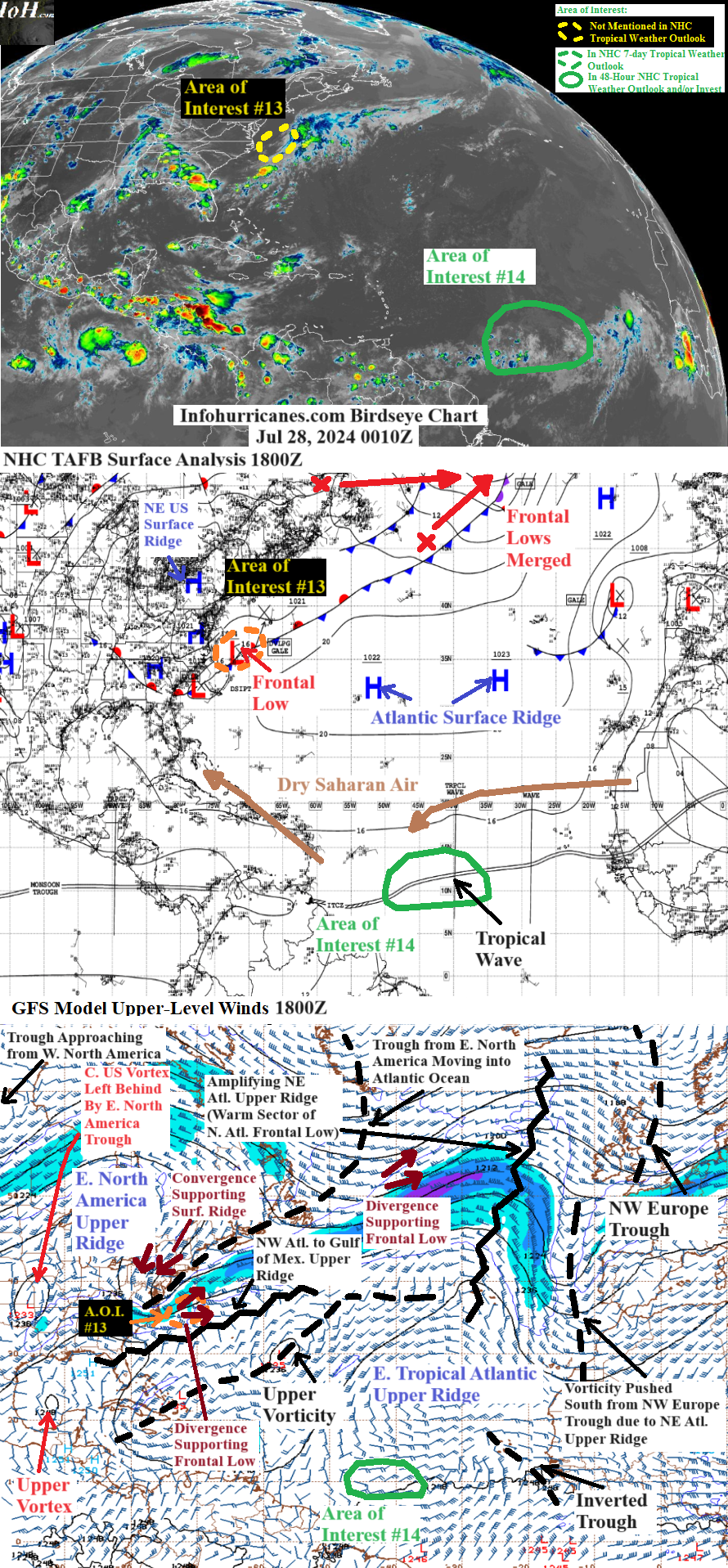
(1) See area of interest #13 section below for information on possible northwest Atlantic tropical cyclone formation in the days ahead associated with a developing surface frontal low… this system will be heading into the northeastern United States by Monday.
(2) See area of interest #14 section below for a complex central tropical Atlantic disturbance that will move into the Lesser Antilles and Caribbean in 4+ days… the north side of the disturbance (to be located over Cuba and the Bahamas) may encounter more favorable upper winds in about a week that could aid in its development.
AREA OF INTEREST #13... The elongated divergence zone of the upper trough currently emerging into the Atlantic from eastern North America is contributing to an elongated frontal surface low pressure offshore of the eastern US and located near 35.5N-71.5W as of 1800Z earlier this evening. Over the next 24 hours the upper ridge now moving into eastern North America will be cutting off a portion of the upper trough into a vortex centered just offshore of the northeastern US… with the more focused divergence zone of the upper vortex potentially allowing for the frontal low to develop a well-defined center while it is still over warm water… therefore keeping the frontal low as an area of interest for tropical development in this update. The updated forecast track in the outlook below is aligned with the latest model consensus which has the surface frontal low hook north and then north-northwest into Cape Cod Massachusetts while it becomes pulled toward the core of the upper vortex. Between 24 and 48 hours the tail half of the current western North America upper trough merges with the current central US upper vortex to make a central North America upper trough that lifts the parent upper vortex of this area of interest north into the northeastern US… which is why the forecast for the surface low shifts north into the Maine/New Hampshire border by 48 hours while the surface low continues to be pulled toward the core of the parent upper vortex. Because the upper vortex is currently materializing a bit north of previous expectations… the surface frontal low is materializing further north and thus it will have less time over warmer waters before its inevitable northward turn… thus I have lowered it peak odds of tropical cyclone formation to 10%.
Impacts to land areas will likely be limited to possible coastal surf for the northeastern United States through Monday. This is due to the fact the surface low will likely be rapidly weakening while moving northward into land areas while having whirled beneath the core of the upper vortex where supportive upper divergence will be lacking (i.e. no non-tropical support mechanism)... combined with the cooler waters providing no tropical support mechanism. However gusty winds cannot be ruled out for Cape Cod Massachusetts and vicinity for early Monday in the event the weakening rate ends up being on the slower side.
******Infohurricanes.com outlook. Visit hurricanes.gov (hurricanes dot gov) for official outlook***********
IOH 24 Hr Outlook (0000Z Jul 29)... 10% chance of tropical cyclone formation (south-southeast of Cape Cod Massachusetts near 39N-69.5W)
IOH 48 Hr Outlook (0000Z Jul 30)… 0% chance of tropical cyclone formation (inland over southern part of Maine/New Hampshire border near 43.5N-71W)
*****National Hurricane Center (hurricanes.gov) official outlook as of 8 PM EDT**************************
Not in the official outlook
AREA OF INTEREST #14... A complex disturbance continues in the central tropical Atlantic consisting of a nearly stationary spin near 10N-45W (confirmable with the CIMSS 850 mb vorticity product… https://tropic.ssec.wisc.edu/real-time/windmain.php?&basin=atlantic&sat=wg8&prod=vor&zoom=&time=) being tugged by a broad tropical wave of low pressure to the east… analyzed by the NHC TAFB to be along 40W longitude. Previous post #52 has more information on the origins of the leading spin near 45W longitude (https://www.infohurricanes.com/post/my-2024-atlantic-hurricane-season-birdseye-view-post-52). Over the next five days the leading spin and broad tropical wave are forecast to merge into one disturbance and head into the Lesser Antilles and eastern Caribbean Sea while pushed west by the Atlantic surface ridge. Although the disturbance is healing for a break in the dry Saharan air… between a large patch of dust in the eastern Atlantic and another large patch over the northeast Caribbean and Bahamas… the disturbance has seen a decrease in thunderstorms this weekend while ingesting some dry Saharan air that is to the north of it. In the short-term upper-levels winds favor this disturbance while it remains under an anticyclonic wave of upper outflow between an inverted upper trough to the east and the current cut-off upper vorticity to the northwest (the inverted upper trough has materialized within the south side of the regional tropical upper ridge... as the east side of the upper ridge has weakened due to the approach of south-sagging high-latitude upper vorticity as noted in the above birdseye view chart). However I show 0% odds of tropical cyclone formation through 72 hours as the disturbance could continue to struggle with dry Saharan air and also struggle to have a well-defined center due to the aforementioned merger between the leading spin and broad wave chasing the spin. The longer-term upper wind outlook (96+ hours) is uncertain... but the models for now seem to agree that the inverted upper trough to the east catches up to the disturbance and merges with some of the cut-off upper vorticity to the northwest… which means by days 4 and 5 overhead suppressing upper vorticity becomes a problem for the disturbance and thus I still keep 0% odds of tropical cyclone formation through that time. Beyond day 5 models begin to disagree on the speed at which the upper vorticity collapses from prolonged isolation from high-latitude cold air into one area of upper vorticity toward Central America and another area of upper vorticity east of the Bahamas. The GFS and NAVGEM which do not develop the disturbance show a slower decay of the upper vorticity… while the ECMWF and CMC are faster with the decay and toward day 7 want to develop the north side of this disturbance (in the vicinity of Cuba or the Bahamas) in an area of upper outflow between the two pieces of decaying upper vorticity. The increasingly aggressive CMC and ECMWF model solutions are likely why the NHC has raised their 7-day tropical cyclone formation probabilities for this area of interest to 40% (note my outlook ends at day 5 as I currently do not do outlooks for areas of interest beyond that timeframe).
Given the above 5-day outlook discussed in the prior paragraph… which expects suppressing upper vorticity to be aligned with this disturbance as it crosses the Lesser Antilles… expecting impacts to the Lesser Antilles from this disturbance to be minimal.
******Infohurricanes.com outlook. Visit hurricanes.gov (hurricanes dot gov) for official outlook***********
IOH 24 Hr Outlook (0000Z Jul 29)… 0% chance of tropical cyclone formation (central tropical Atlantic near 11N-45W)
IOH 48 Hr Outlook (0000Z Jul 30)... 0% chance of tropical cyclone formation (central tropical Atlantic near 11.5N-50W)
IOH 72 Hr Outlook (0000Z Jul 31)... 0% chance of tropical cyclone formation (east of the southern Lesser Antilles near 12N-55W)
IOH 96 Hr Outlook (0000Z Aug 1)… 0% chance of tropical cyclone formation (southern Lesser Antilles near 13N-60.5W)
IOH 120 Hr Outlook (0000Z Aug 2)… 0% chance of tropical cyclone formation (eastern Caribbean Sea near 14N-66W)
*****National Hurricane Center (hurricanes.gov) official outlook as of 8 PM EDT**************************
Formation chance through 48 hours... 0%
Formation chance through 7 days... 40%
...COMPUTER MODEL SUMMARY...
Source...Florida State University Experimental Forecast Tropical Cyclone Genesis Potential Fields (http://moe.met.fsu.edu/tcgengifs/).
1200Z (Jul 27) CMC Model Run...
**For area of interest #13... through 30 hours a frontal cyclone with possible tropical characteristics develops southeast of Massachusetts near 38N-68.8W… the surface low/cyclone weakens while moving into Cape Cod Massachusetts through 54 hours and dissipates over southern Maine by 72 hours
**For area of interest #14... passes over the northern Lesser Antilles by 96 hours as an amplified wave… the amplified wave crosses the remainder of the northern Caribbean Islands (Virgin Islands… Puerto Rico… Haiti… Dominican Republic… and Cuba) through 150 hours while slowly becoming a tropical low… tropical low centered just south of the isle of youth of western Cuba at 168 hours
1200Z (Jul 27) ECMWF Model Run...
**For area of interest #13... through 12 hours a compact frontal cyclone with possible tropical characteristics develops near 35.8N-71W… center of cyclone reaches Cape Cod Massachusetts at 42 hours and rapidly dissipates inland over the southern New Hampshire/Maine border by 54 hours
**For area of interest #14... passes over the northern Lesser Antilles by 102 hours as an amplified wave and develops into a tropical low over the southeastern Bahamas at 144 hours and develops into a tropical depression over northwest Bahamas by 168 hours
1200Z (Jul 27) GFS Model Run...
**For area of interest #13... through 30 hours a frontal cyclone with possible tropical characteristics develops southeast of Massachusetts near 39.2N-68.5W… whirls northwest into Cape Cod Massachusetts through 45 hours with the surface cyclone/low subsequently weakening and dissipating over southeastern Maine by 66 hours
**For area of interest #14... no development shown
1200Z (Jul 27) NAVGEM Model Run...
**For area of interest #13... through 30 hours a frontal cyclone with possible tropical characteristics develops southeast of Massachusetts near 39N-68.5W… whirls northwest into Cape Cod Massachusetts through 48 hours while weakening… dissipates over southern New Hampshire by 72 hours
**For area of interest #14... no development shown


Comments