MY 2023 ATLANTIC HURRICANE SEASON BIRDSEYE VIEW POST #54
- NCHurricane2009

- Aug 15, 2023
- 6 min read
*******Note that forecast and outlooks in this post are NOT the official forecast from the National Hurricane Center (NHC). They are my own detailed views on the Atlantic tropics based on current observations and latest computer model runs. As such do not make decisions based on my posts...consult news media...watches and warnings from your local weather office...and any evacuation orders issued by local governments to make the most informed and best decisions. Visit the NHC website hurricanes.gov (hurricanes dot gov) for the latest watches/warnings and official forecasts on active tropical cyclones.**********
…TUESDAY AUGUST 15 2023 2:45 AM EDT...
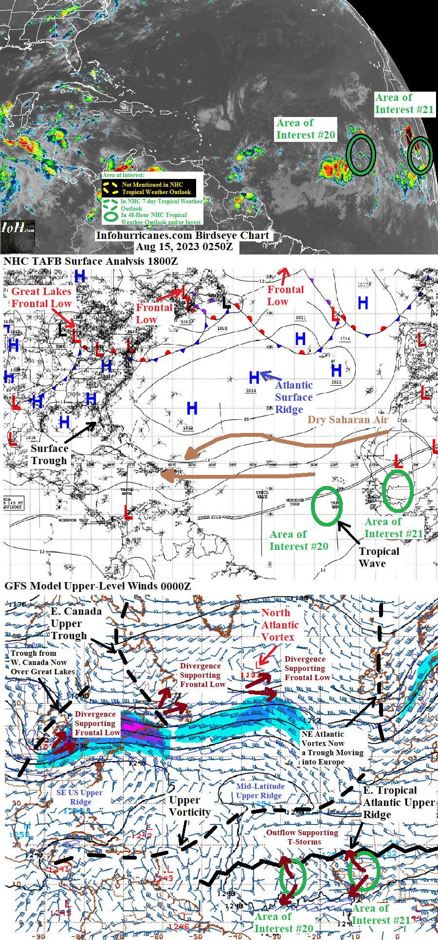
The surface trough of low pressure in the eastern Gulf of Mexico continues to feature disorganized thunderstorm activity… and in the next 24 hours will move north into the Florida panhandle while heading toward the surface ridge weakness associated with the developing Great Lakes frontal low. Therefore tropical development of this feature is not expected.
Elsewhere... the current mid-latitude upper ridge over the Atlantic is forecast to push upper vorticity trapped in the Atlantic tropics westward toward the western Atlantic and Caribbean. Within the next few days this will allow tropical upper ridging with low shear and upper outflow to recover in the eastern and central tropical Atlantic. Therefore continuing to keep an eye on surface tropical waves of low pressure currently spanning from the central Atlantic to Africa which may later take advantage of the recovering tropical upper ridging:
(1) The first such wave is currently in the central Atlantic near 40W longitude and is large in size which has allowed it to inhale suppressing dry Saharan air from the north. Meanwhile over the last day or so the east side of this wave has left behind a gyre of rotating showers and thunderstorms near 25W longitude which has recently been upgraded to a separate tropical wave now being monitored by the NHC for signs of development. See area of interest #20 section below for more information.
(2) Animation of METEOSAT satellite imagery
(https://tropic.ssec.wisc.edu/real-time/europe/movies/m7irn/m7irn_loop.html) suggests an organized tropical wave from central Africa has merged with another wave that was over Western Africa. This merged wave… which continues to have some signs of organization while featuring a large gyre of scattered thunderstorms… is also now being monitored by the NHC for signs of development. See area of interest #21 section below for more information.
AREA OF INTEREST #20…A tropical wave of low pressure in the eastern Atlantic is producing a gyre of scatters showers and thunderstorms centered near 13N-26W as of this writing… and is now being monitored by the NHC for signs of tropical development. This marks the twentieth Atlantic tropical area of interest tracked on this site this year. This system is forecast to initially angle
more north in its westward track while continuing to be pulled by the east side of the adjacent large wave near 40W… followed by less northward angle once it bumps into the Atlantic surface ridge. I set peak odds of tropical cyclone formation lower than the NHC at this time as the gyre lacks core thunderstorms to insulate it from dry Saharan air that lies ahead to the northwest… and also as computer model support developing this system is currently lacking.
Update as of 2 AM EDT… the NHC has recently dropped odds of development for this area of interest from 20% to 10%.
******Infohurricanes.com outlook. Visit hurricanes.gov (hurricanes dot gov) for official outlook***********
IOH 24 Hr Outlook (0000Z Aug 16)… 0% chance of tropical cyclone formation (eastern tropical Atlantic near 14N-30W)
IOH 48 Hr Outlook (0000Z Aug 17)… 5% chance of tropical cyclone formation (eastern tropical Atlantic near 14.5N-35W)
IOH 72 Hr Outlook (0000Z Aug 18)… 10% chance of tropical cyclone formation (central tropical Atlantic near 15N-40W)
IOH 96 Hr Outlook (0000Z Aug 19)… 10% chance of tropical cyclone formation (central tropical Atlantic near 15.5N-45W)
IOH 120 Hr Outlook (0000Z Aug 20)… 10% chance of tropical cyclone formation (central tropical Atlantic near 16N-50W)
****** National Hurricane Center (hurricanes.gov) official outlook as of 2 AM EDT*****************************
Formation chance through 48 hours…0%
Formation chance through 7 days (168 hours)...10%
AREA OF INTEREST #21…A tropical wave of low pressure over Western Africa is producing a large gyre of scatters showers and thunderstorms centered near 15N-9W as of this writing… and is now being monitored by the NHC for signs of tropical development. This marks the twenty-first Atlantic tropical area of interest tracked on this site this year. Some northward angle in the westward track is anticipated during the 5-day forecast period as… (1) the current North Atlantic upper vortex and current eastern Canada upper trough merge and creating a strong northeast Atlantic frontal cyclone that weakens the eastern part of the Atlantic surface ridge… (2) as the eastern part of the current mid-latitude upper vorticity gets pushed southward toward this tropical wave by the current mid-latitude upper ridge… potentially providing a northward pull in the upper layer steering especially if this system becomes stronger/taller. I agree that this area of interest (AOI) has higher odds of development than AOI #20 due to more model support showing development… however at this time I keep peak odds lower than the NHC guidance as the west-northwest track in the long range brings this system closer to dry Saharan air and also westerly shear associated with the aforementioned upper vorticity. This long range less favorable environment is also why by day 5 I lower development odds from the peak.
Note that regardless of tropical cyclone formation or not… this system may produce gusty winds and heavy rainfall over the Republic of Cabo Verde Islands in the Wednesday to Thursday timeframe.
******Infohurricanes.com outlook. Visit hurricanes.gov (hurricanes dot gov) for official outlook***********
IOH 24 Hr Outlook (0000Z Aug 16)… 0% chance of tropical cyclone formation (western Africa near 15N-14W)
IOH 48 Hr Outlook (0000Z Aug 17)… 0% chance of tropical cyclone formation (east of the Republic of Cabo Verde Islands near 15N-19W)
IOH 72 Hr Outlook (0000Z Aug 18)… 10% chance of tropical cyclone formation (Republic of Cabo Verde Islands near 16N-24W)
IOH 96 Hr Outlook (0000Z Aug 19)… 15% chance of tropical cyclone formation (eastern tropical Atlantic near 17.5N-29W)
IOH 120 Hr Outlook (0000Z Aug 20)… 10% chance of tropical cyclone formation (eastern tropical Atlantic near 19N-32.5W)
******National Hurricane Center (hurricanes.gov) official outlook as of 2 AM EDT*****************************
Formation chance through 48 hours…0%
Formation chance through 7 days (168 hours)...30%
...COMPUTER MODEL SUMMARY...
Source...Florida State University Experimental Forecast Tropical Cyclone Genesis Potential Fields (http://moe.met.fsu.edu/tcgengifs/).
1200Z (Aug 14) CMC Model Run...
**For area of interest #20… tropical wave currently near 25W longitude evolves into a tropical low near 13N-36W at 60 hours… tropical cyclone formation suggested near 15N-42W at 96 hours… tropical cyclone located at 17.5N-46W at 120 hours
**For area of interest #21… no development shown
**Additional tropical wave emerges from the west coast of Africa at 150 hours and evolves into a tropical low just east of the Republic of Cabo Verde Islands by 168 hours
**North end of tropical wave currently at 40W evolves into a tropical low over the west tip of Cuba at 144 hours… central Gulf of Mexico tropical cyclone formation suggested at 168 hours
1200Z (Aug 14) ECMWF Model Run...
**For area of interest #20… no development shown
**For area of interest #21… merged tropical wave currently over western Africa passes over the Republic of Cabo Verde Islands at 42 hours and evolves into a tropical low west of the islands at 84 hours… evolves into a large weak tropical cyclone near 17N-32.5W at 108 hours which reaches 18.2N-33.5W at 120 hours
1200Z (Aug 14) GFS Model Run...
** For area of interest #20… no development shown
**For area of interest #21… merged tropical wave currently over western Africa evolves into a southwest-northeast elongated tropical low over the Republic of Cabo Verde Islands at 72 hours… through 105 hours the elongated circulation consolidates into a tropical cyclone located just northwest of the islands… tropical cyclone reaches 20N-29W at 120 hours
1200Z (Aug 14) NAVGEM Model Run...
**For area of interest #21… merged tropical wave currently over Western Africa absorbs AOI #20 through 48 hours which results in an elongate southwest-northwest trough from the west coast of Mauritania to the waters southwest of the islands… tropical low develops along the trough and just southwest of the islands by 84 hours… tropical low moves northwest to 18N-29W through 120 hours while evolving into a tropical cyclone


Comments