MY 2022 ATLANTIC HURRICANE SEASON BIRDSEYE VIEW POST #69
- NCHurricane2009

- Aug 9, 2022
- 4 min read
Updated: Aug 9, 2022
*******Note that forecasts and outlooks in this post are NOT the official forecast from the National Hurricane Center (NHC). They are my own detailed views on the Atlantic tropics based on current observations and latest computer model runs. As such do not make decisions based on my posts...consult news media...watches and warnings from your local weather office...and any evacuation orders issued by local governments to make the most informed and best decisions. Visit the NHC website hurricanes.gov (hurricanes dot gov) for the latest watches/warnings and official forecasts on active tropical cyclones.**********
...TUESDAY AUGUST 9 2022 1:19 AM EDT...
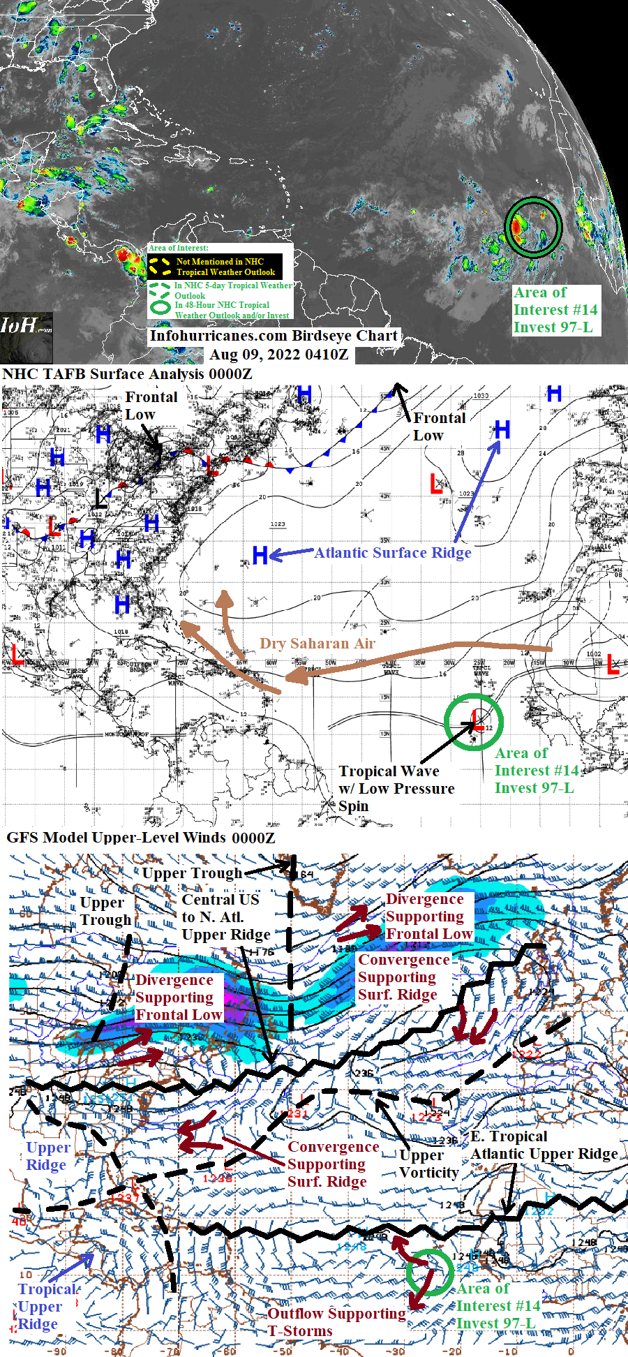
See area of interest #14 section below for more information on the tropical wave of low pressure currently in the eastern tropical Atlantic... which continues to be monitored for signs of tropical development. Elsewhere... the current surface frontal system and its associated upper trough moving into central Canada is expected to emerge into the western Atlantic from the United States east coast in 4 to 6 days. As suggested mainly by some runs of the GFS model... the frontal system may become a focal point for subtropical or tropical development in the waters between Bermuda and the United States east coast during that time frame. Their is some uncertainty as to the state the associated upper trough will be in... a more amplified upper trough closer to the United States east coast would allow the divergent east side of the upper trough to spawn a surface low pressure area without excessively shearing it which would otherwise inhibit tropical development. On the other hand a more offshore and less amplified upper trough would increase wind shear in the region and make conditions more hostile for tropical development. Holding off on declaring another area of interest for this situation until it is clear which scenario is more likely.
New to this site this year... I will be sequentially numbering up areas of interest for possible Atlantic tropical development. In this scheme... will reset back to #1 at the start of next year (January 2023). The current area of interest in this blog post is designated #14 as I designated the other thirteen of this year in previous birdseye view posts on the home page. This scheme is to reduce confusion as Atlantic tropical activity increases during the peak of the hurricane season... when multiple simultaneous areas of interest begin and end which previously required shuffling around the area of interest numbers from update to update.
AREA OF INTEREST #14...Over the last 24 hours... the tropical wave of low pressure in the eastern tropical Atlantic has advanced from 20W to 25W longitude. The thunderstorm activity has also become better aligned with the wave axis and taken on a general spiral banding pattern...particularly on the west side of the tropical wave. The spiral banding suggests the development of a low pressure spin on the wave axis which is confirmed in the latest NHC TAFB surface analysis.
Regarding the track forecast in the outlook below... the tropical wave is shown progressing westward at a typical 5W per day longitude pace while the wave remains steered by the Atlantic surface ridge. The west side of this ridge is expected to weaken in a few days while the current frontal system moving into central Canada advances into the western Atlantic... which will allow this system to bend more north in its westward track by days 3 to 5. Regarding the probability of tropical cyclone formation...the vast tropical upper ridge in the region with low shear and upper outflow will be a benefit for this tropical wave. In addition the tropical wave continues to mature while now having established a spin with spiral banding features despite the presence of dry saharan air to the north... indicating the dry air has not been able to inhibit this tropical wave. Therefore in this update I have raised my peak 5-day odds of tropical cyclone to 50% (this is above the NHC 5-day outlook 40% odds as of this writing).
******Infohurricanes.com outlook. Visit hurricanes.gov (hurricanes dot gov) for official outlook***********
IOH 24 Hr Outlook (0000Z Aug 10)...20% chance of tropical cyclone formation (eastern tropical Atlantic near 12.5N-30W)
IOH 48 Hr Outlook (0000Z Aug 11)...40% chance of tropical cyclone formation (eastern tropical Atlantic near 12.5N-35W)
IOH 72 Hr Outlook (0000Z Aug 12)...50% chance of tropical cyclone formation (central tropical Atlantic near 13.5N-40W)
IOH 96 Hr Outlook (0000Z Aug 13)...50% chance of tropical cyclone formation (central tropical Atlantic near 15N-45W)
IOH 120 Hr Outlook (0000Z Aug 14)...50% chance of tropical cyclone formation (central tropical Atlantic near 16.5N-50W)
...COMPUTER MODEL SUMMARY...
Source...Florida State University Experimental Forecast Tropical Cyclone Genesis Potential Fields (http://moe.met.fsu.edu/tcgengifs/)
1200Z (Aug 8) CMC Model Run...
**For area of interest #14...no development shown
1200Z (Aug 8) ECMWF Model Run...
**For area of interest #14...no development shown
1800Z (Aug 8) GFS Model Run...
**For area of interest #14...tropical cyclone formation suggested near 12.5N-35W at 54 hours... moves west-northwest across the eastern and central tropical Atlantic while maintaining weak tropical cyclone status (tropical depression/tropical storm)... weak tropical cyclone located near 17N-53.5W at 120 hours
1800Z (Aug 8) NAVGEM Model Run...
**For area of interest #14...no development shown


Comments