MY 2022 ATLANTIC HURRICANE SEASON BIRDSEYE VIEW POST #154
- NCHurricane2009

- Nov 11, 2022
- 10 min read
*******Note that forecast and outlooks in this post are NOT the official forecast from the National Hurricane Center (NHC). They are my own detailed views on the Atlantic tropics based on current observations and latest computer model runs. As such do not make decisions based on my posts...consult news media...watches and warnings from your local weather office...and any evacuation orders issued by local governments to make the most informed and best decisions. Visit the NHC website hurricanes.gov (hurricanes dot gov) for the latest watches/warnings and official forecasts on active tropical cyclones.**********
...FRIDAY NOVEMBER 11 2022 5:00 AM EDT...
Nicole has weakened to an inland tropical depression over the southeastern United States. Impacts from this system are expected to shift northward across the entire eastern US seaboard and into Atlantic Canada today and through Saturday once Nicole transitions into a remnant frontal cyclone... see Nicole section below for more information on the storm.
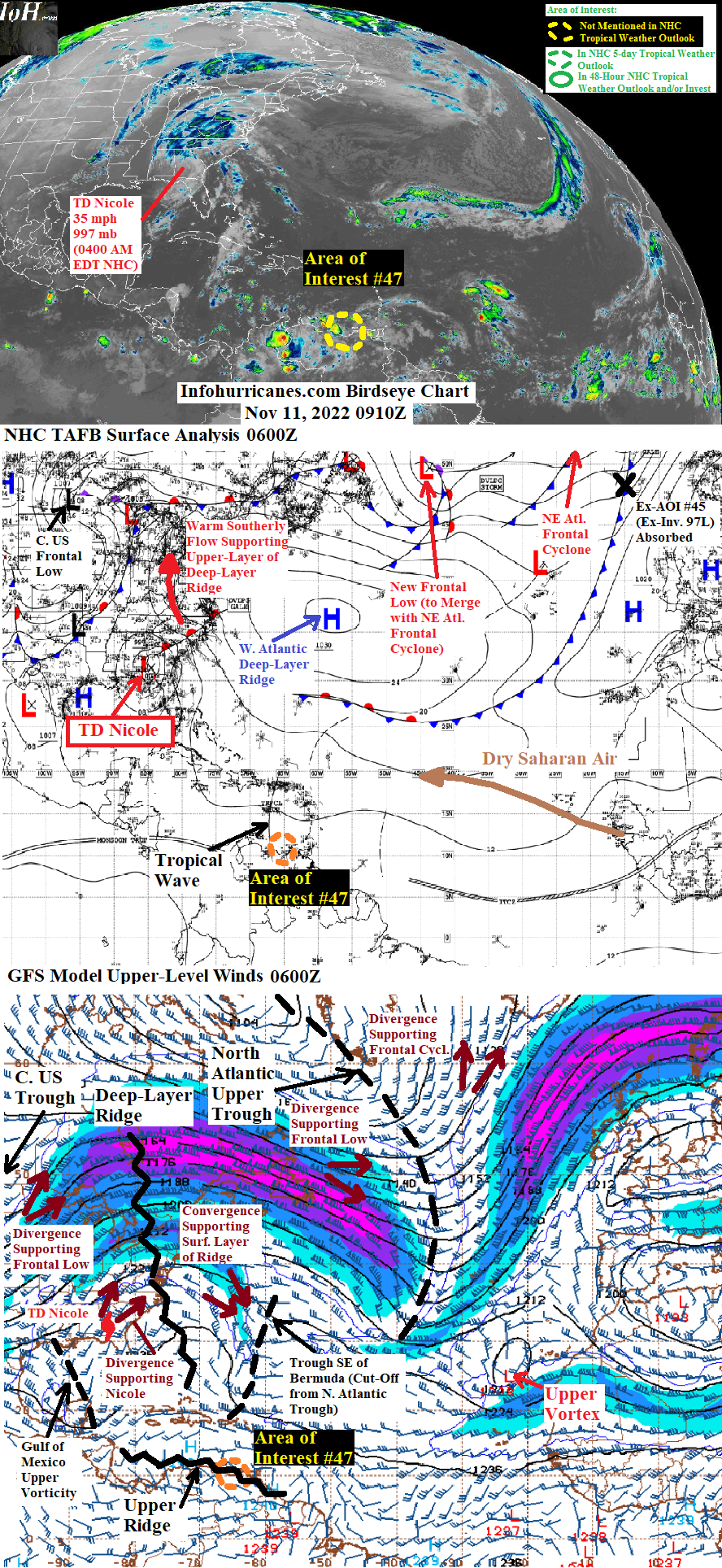
Elsewhere... noting the following other areas of interest:
(1) A tropical wave of low pressure currently located along the north coast of Venezuela continues to show well-defined rotation. The wave has potential to develop while later moving toward Central America. See area of interest #47 section below for more information.
(2) Models generally agree that the current western Atlantic deep-layer ridge will be strong enough to cut-off portions of the current north Atlantic upper trough. The western cut-off upper trough is already setting up southeast of Bermuda and will watch to see if a subtropical disturbance develops below the low shear and eastern divergence zone to setup underneath its east side. The eastern cut-off upper trough is still forecast to setup west of the Canary Islands in the eastern subtropical Atlantic... however the latest indications are that this trough will not be totally cut-off from the mid-latitude westerlies such that it drifts eastward. In combination with the strength of the deep-layer ridge... whatever surface low pressure develops west of the Canary Islands will accelerate southwest into upper convergence between the west side of the eastward-shifting upper trough and southeast side of the deep-layer ridge... the upper convergence environment therefore will not be conducive for subtropical development west of the Canary Islands.
New to this site this year... I will be sequentially numbering up areas of interest for possible Atlantic tropical development. In this scheme... will reset back to #1 at the start of next year (January 2023). The current area of interest in this blog post is designated #47 as the other numbers were used in previous birdseye view posts. This scheme is to reduce confusion as Atlantic tropical activity increases during the peak of the hurricane season... when multiple simultaneous areas of interest begin and end which previously required shuffling around the area of interest numbers from update to update.
TROPICAL DEPRESSION NICOLE... To the left is satellite imagery as Hurricane Nicole makes landfall early on Thursday morning. The center and right show Nicole weakening as an inland tropical storm over northwest Florida and heading into southwestern Georgia by Thursday late morning through late evening. The top row uses colorized infrared satellite scheme while the bottom row uses nighttime un-colorized infrared/daytime true-color visible schemes. For each snapshot... the intensity of the storm is denoted with max sustained winds (mph) and minimum central pressure (mb):

After the center of circulation of Nicole made landfall in southeast Florida early Thursday (between West Palm Beach and Cape Canaveral)... the storm proceeded to move northwestward across Florida and now into southwestern Georgia while rounding the west side of the steering deep-layer ridge now in the western Atlantic. The center of circulation essentially followed the previous forecast track line while moving over/near the northwestern Florida peninsula coast... then over/near the eastern Florida panhandle coast just to the east of the Big Bend region. However the storm has moved a bit faster along this line than the previous foreast while already centered well inland over southwestern Georgia as of this writing. Regarding strength... I previously forecasted Nicole to weaken only gradually despite land interaction with Florida as the large outer circulation of the storm would still be able to tap into surrounding eastern Gulf of Mexico/western Atlantic warm waters. Through 1300Z Thursday this was the case as Nicole redeveloped a central area of thunderstorms while moving across the Florida peninsula... however due to subsequent loss of this core activity and due to already being located well inland... Nicole is now weaker than my previous forecast while recently having weakened to a tropical depression... in all Nicole has weakened from a category 1 hurricane to a depression in 24 hours. The more recent weakening is also explained by the fact the eastern divergence zone of the incoming amplified central US upper trough has not arrived yet to come to Nicole's aid.
Going forward and over the next 24 hours... Nicole is expected to vault northward across the eastern US in the strong southerly flow ahead of the aforementioned central US upper trough and associated strong surface frontal system. My updated forecast track below is a northward adjustment over the previous due to the current position of the storm. Nicole is also expected to lose tropical characteristics but also regain strength due to eastern divergence zone of incoming upper trough. There remains debate in the models as to whether or not on whether or not Nicole's remnant frontal cyclone will become the dominant... or if the divergence maximum of the upper trough sets up a little further north to produce a frontal cyclone just north of Nicole such that Nicole's remnant cyclone loses identity within the dominating northern one. For now I assume Nicole's remnant cyclone will be the dominant since the forecast track is already adjusted north due to the storm's current position... so Nicole will be aligned with the upper trough's divergence maximum even if the maximum were to setup further north. Either way... wind/coastal surf impacts are set to spread across the entire eastern US seaboard and Atlantic Canada from now through Saturday. If Nicole's remnant cyclone does go on to become the dominant while sliding across Atlantic Canada... it is then expected to turn rapidly east out to sea and into the strong cyclonic flow to setup in the northeast Atlantic (the northeast Atlantic cyclonic flow will setup as the current north Atlanitc upper trough... as well as the current new frontal low offshore of Newfoundland and current northeast Atlantic frontal cyclones... all merge). Depending on the exact track Nicole's remnant cyclone takes within this cyclonic flow... it could pass near enough the British Isles and Iceland to also bring wind/coastal surf impacts there in the 4 to 5 day range.
Regarding impact to land areas:
(1) For Florida... coastal surf... rainfall... and wind impacts have decreased as Nicole has weakened to a tropical depression while also lifting northward and away. The following are peak reports of wind at National Weather Service stations across Florida and generated by Nicole over the last several hours listed in mph. Due to the number of wind reports... called out the region of the state for each location (northeast... southeast... etc.):
**Port Saint Lucie (southeast FL)... sustained 32... gust 43... 4:55 AM EDT Thursday
**West Palm Beach (southeast FL)... sustained 31... gust 40... 12:53 AM EDT Thursday
**Miami (southeast FL)... sustained 14... gust 30... 12:53 AM EDT Thursday
**Marathon (FL Keys)... sustained 16... gust 32... 9:53 PM EDT Wednesday
**Port Charlotte (southwest FL)... sustained 25... gust 36... 7:53 AM EDT Thursday
**Melbourne (east-central FL)... sustained 52... gust 64... 2:53 AM EDT Thursday
**Cape Canaveral (east-central FL)... sustained 43... gust 60... 4:55 AM EDT Thursday
**Orlando (central FL)... sustained 36... gust 54... 6:53 AM EDT Thursday
**Lakeland (central FL)... sustained 26... gust 36... 11:50 AM EDT Thursday
**Tampa (west-central FL)... sustained 24... gust 43... 1:53 PM EDT Thursday
**Gainesville (north-central FL)... sustained 29... gust 49... 2:53 PM EDT Thursday
**Jacksonville (northeast FL)... sustained 32... gust 51... 1:53 PM Thursday
**Cross City (northwest FL)... sustained 31... gust 46... 11:15 AM EDT Thursday
**Perry (northwest FL)... sustained 28... gust 41... 12:35 AM EDT Thursday
**Saint Marks (northwest FL eastern Panhandle)... sustained 23... gust 37... 3:53 PM EDT Thursday
(2) For Georgia and the Carolinas... Nicole's wind field and Atlantic coastal surf has relaxed as it has weakened to a tropical depression... however wind (both coastal and inland) with isolated damage potential and coastal surf is expected to increase later today and particularly across the Carolinas as Nicole transitions into a strengthening non-tropical frontal cyclone. Heavy rainfall with flash flooding potential will be another hazard to consider. The Storm Prediction Center (spc.noaa.gov) has identified an area of instability and vertical wind shear setting up in the northeast quadrant of Nicole's circulation... caused by warm surface southeasterly flow on Nicole's northeast side and cool upper southwesterly flow associated with the incoming upper trough which is creating a risk for severe thunderstorms and tornadoes for the eastern half of the Carolinas from now thorugh tonight... have a way to monitor severe weather watches/warnings (weather radio or local media) throughout today. The following are peak reports of wind at National Weather Service stations across Georgia and the Carolinas and generated by Nicole so far listed in mph. Due to the number of wind reports... called out the region of the state for each location (northeast... southeast... etc.):
**Brunswick (southeast GA)... sustained 29... gust 47... 8:53 AM EDT Thursday
**Savannah (southeast GA)... sustained 17... gust 30... 7:55 PM EDT Thursday
**Valdosta (south-central GA)... sustained 31... gust 44... 2:53 PM EDT Thursday
**Tifton (south-central GA)... sustained 23... gust 35... 4:15 PM EDT Thursday
**Bainbridge (southwestern GA)... sustained 18... gust 30... 3:53 PM EDT Thursday
**Moultrie (southwestern GA)... sustained 23... gust 35... 4:16 PM EDT Thusrday
**Albany (southwestern GA)... sustained 20... gust 36... 6:53 PM EDT Thursday
**Macon (central GA)... sustained 21... gust 35... 6:53 PM EDT Thursday
**Atlanta (central GA)... sustained 22... gust 33... 7:52 PM EDT Thursday
**Gainesville (north-central GA)... sustained 18... gust 38... 9:53 PM EDT Thursday
**Anderson (western SC)... sustained 16... gust 28... 8:56 PM EDT Thursday
**Columbia (central SC)... sustained 12... gust 23... 6:53 PM EDT Thursday
**Charleston (southern SC)... sustained 16... gust 35... 3:56 PM EDT Thursday
**Myrtle Beach (northeastern SC)... sustained 21... gust 31... 11:56 PM EDT Thursday
(3) For Virginia... West Virignia... Maryland... Delaware... Pennsylvania... New Jersey... New York... Connecticut... Rhode Island... Massachusetts... Vermont... New Hampshire... Maine... New Brunswick... Nova Scotia... Prince Edward Island... southeastern Quebec... and Newfoundland... Nicole's remnant frontal cyclone (or a northern frontal cyclone that quickly forms and absorbs Nicole's remnant cyclone) is exepcted to bring coastal surf and gusty winds with isolated damage potential by Saturday... and as soon as tonight further south. The potential for flooding rains in this region is low as Nicole is expected to be accelerating rapidly across the region... reducing the amount of rainfall time. The Storm Prediction Center (spc.noaa.gov) has identified an area of instability and vertical wind shear setting up in the northeast quadrant of Nicole's circulation... caused by warm surface southeasterly flow on Nicole's northeast side and cool upper southwesterly flow associated with the incoming upper trough which is creating a risk for severe thunderstorms and tornadoes for southeastern Virginia by tonight... have a way to monitor severe weather watches/warnings (weather radio or local media) during this time.
******Infohurricanes.com forecast. Visit hurricanes.gov (hurricanes dot gov) for official forecast***********
0 Hr Position (0600Z Nov 11)... 35 mph maximum sustained wind tropical depression centered over southwestern Georgia at 31.5N-84.3W
IOH 24 Hr Forecast (0600Z Nov 12)... Remnant frontal cyclone centered over the northern tip of Virginia at 38.8N-77.5W
AREA OF INTEREST #47...Based on satellite imagery as of this writing... the maximum spin of the tropical wave of low pressure that has recently entered the southeastern Caribbean Sea appears to be along the north coast of Venezuela near 65W longitude and based on the curvature of surrounding cloud and scattered thunderstorm activity. Therefore I continue to maintain this tropical wave as an area of interest for tropical development in the days ahead. This system is expected to continue westward across the north coast of South America and then the southern Caribbean Sea at varying speeds over the next five days... and the forecast track in the outlook below is adjusted based on the current position of the wave's maximum spin. The forward speed of the wave is expected to be sluggish over the next three days while encountering an area of weaker easterly surface trade winds caused by the surface ridge weakness of Nicole and a potential additional subtropical disturbance to form southeast of Bermuda in the days ahead (see intro section of this blog post for more info on the potential disturbance). The current lack of a consolidated circulation center and land interaction with northern South America should limit development potential over the next 3 to 4 days... therefore in this update I set development odds to 0% during this timeframe. In addition and over the next 24 hours... this system will encounter increased northwesterly wind shear to be caused by the southwest side of the upper vorticity of the possible subtropical disturbance southeast of Bermuda. A second dose of shear is expected around day 3 as the upper vorticity currently in the Gulf of Mexico gets pushed eastward toward this tropical wave by the amplified upper trough to approach from its current central US position. Note that after this upper vorticity moves away... there is potential for this tropical wave to encounter more favorable low shear to the east of Central America in 4+ days. In addition a surface ridge to build over North America in the wake of the aformentioned upper trough and upper vorticity would also accelerate the tropical wave westward toward Central America. Therefore this tropical wave may also require monitoring as it moves toward Central America in the 4+ day window... and this is when I also set odds of development to a low 10%. The odds are set to a low value as computer models do not show this tropical wave developing at the present time.
Even though short-term tropical cyclone formation is not anticipated with this tropical wave... it has potential to bring periods of heavy rains and gusty winds to northern Venezeula and Colombia as well as the ABC Islands (Aruba Bonaire and Curacao) over the next couple of days.
******Infohurricanes.com outlook. Visit hurricanes.gov (hurricanes dot gov) for official outlook***********
IOH 24 Hr Outlook (0600Z Nov 12)... 0% chance of tropical cyclone formation (northwest coast of Venezuela near 10.5N-68W)
IOH 48 Hr Outlook (0600Z Nov 13)... 0% chance of tropical cyclone formation (northwest coast of Venezuela near 11.2N-70.5W)
IOH 72 Hr Outlook (0600Z Nov 14)... 0% chance of tropical cyclone formation (north coast of Colombia near 11.5N-72.5W)
IOH 96 Hr Outlook (0600Z Nov 15)... 0% chance of tropical cyclone formation (southern Caribbean Sea near 12N-75.5W)
IOH 120 Hr Outlook (0600Z Nov 16)... 10% chance of tropical cyclone formation (southern Caribbean Sea near 12N-80W)
...COMPUTER MODEL SUMMARY...
Source...Florida State University Experimental Forecast Tropical Cyclone Genesis Potential Fields (http://moe.met.fsu.edu/tcgengifs/)
0000Z (Nov 11) CMC Model Run...
**For Tropical Depression Nicole... transitions into a remnant frontal low centered just east of the North Carolina/Tennessee border at 18 hours... remnant low subsequently strengthens to a broad frontal cyclone over the northeastern US by 36 hours which swings east into Atlantic Canada by 48 hours and rapidly accelerates east into the northeast Atlantic near 48.5N-23.5W by 78 hours... subsequently begins a cyclonic loop around current larger northeast Atlantic frontal cyclonic system which causes Nicole's remnant cyclone to pass just west of the British Isles at 96 hours and meanders at this location through 120 hours.
**For area of interest #47... no development shown
1200Z (Nov 10) ECMWF Model Run...
**For Tropical Depression Nicole... transitions into a remnant frontal low centered over the northern Georgia/South Carolina border at 30 hours... shortly after this time a developing frontal low to the north becomes the dominant system in the region with Nicole's remnants losing its identity along the cold front of the dominating system.
**For area of interest #47... no development shown
0000Z (Nov 11) GFS Model Run...
**For Tropical Depression Nicole... transitions into a remnant frontal low centered just east of the North Carolina/Tennessee border at 18 hours... remnant low subsequently strengthens to a broad frontal cyclone over the northeastern US by 39 hours which swings east into Atlantic Canada by 51 hours and rapidly accelerates east into the northeast Atlantic near 48N-21.5W by 75 hours... subsequently begins a cyclonic loop around current larger northeast Atlantic frontal cyclonic system which causes Nicole's remnant cyclone to pass just west of the British Isles at 84 hours and just south of Iceland near 61N-20.5W by 120 hours.
**For area of interest #47... no development shown
0000Z (Nov 11) NAVGEM Model Run...
**Not available at above mentioned source


Comments