MY 2022 ATLANTIC HURRICANE SEASON BIRDSEYE VIEW POST #146
- NCHurricane2009

- Nov 2, 2022
- 12 min read
Updated: Nov 3, 2022
*******Note that forecast and outlooks in this post are NOT the official forecast from the National Hurricane Center (NHC). They are my own detailed views on the Atlantic tropics based on current observations and latest computer model runs. As such do not make decisions based on my posts...consult news media...watches and warnings from your local weather office...and any evacuation orders issued by local governments to make the most informed and best decisions. Visit the NHC website hurricanes.gov (hurricanes dot gov) for the latest watches/warnings and official forecasts on active tropical cyclones.**********
...UPDATE... WEDNESDAY NOVEMBER 2 2022 7:52 AM EDT...
Lisa in the western Caribbean Sea has been upgraded to a category 1 hurricane by the National Hurricane Center. Maximum sustained winds are 75 mph with a minimum central pressure of of 988 mb.
...WENDESDAY NOVEMBER 2 2022 7:35 AM EDT...
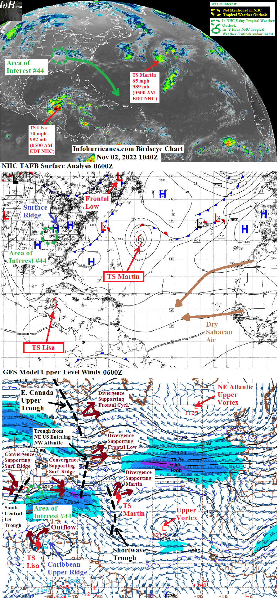
The Atlantic tropics are expected to remain active across the Caribbean region over the next few days as follows:
(1) Tropical Strom Lisa currently in the western Caribbean is expeced to make landfall across Belize... northern Guatemala... and parts of southeastern Mexico later today... see Lisa section below for more information.
(2) The current south-central US upper trough is forecast to move into the western Atlantic over the next three days where it is forecast to evolve into a cut-off upper vortex. This vortex is expected to notably increase disturbed weather from the central to northeast Caribbean... and western Atlantic waters just north of the northeastern Caribbean... in 3 to 5 days. See area of interest #44 section below for more details.
Elsewhere... the subtropical low pressure area in the open central Atlantic has gained enough tropical characteristics to now be Tropical Storm Martin... and Martin is already approaching hurricane strength. See Martin section below for more information on this storm.
New to this site this year... I will be sequentially numbering up areas of interest for possible Atlantic tropical development. In this scheme... will reset back to #1 at the start of next year (January 2023). The current area of interest in this blog post is designated #44 as the other numbers were used in previous birdseye view posts. This scheme is to reduce confusion as Atlantic tropical activity increases during the peak of the hurricane season... when multiple simultaneous areas of interest begin and end which previously required shuffling around the area of interest numbers from update to update.
TROPICAL STORM LISA... The western convergence zones of upper trough fragments over the northeastern and south-central US have built on surface ridging due north of Tropical Storm Lisa. Under the influence of the surface ridging... Lisa has moved faster to the west than previous forecasts. This has allowed Lisa to move beneath the west side of the current Caribbean upper ridge cell where upper southerly flow has helped drag the tropical storm more northward which has kept the westward-moving storm offshore of Honduras. These changes result in a notable northwest shift of the forecast track relative to previous forecasts... now on a path to cross over Belize... northern Guatemala... Campeche and Tabasco provinces... and possibly the Bay of Campeche if Lisa's circulation can hang on while interacting with land by 48+ hours. The NHC has elected to forecast Lisa redeveloping into a tropical depression in the Bay of Campeche with these latest development... given the 50/50 mix of solutions shown in the computer model summary section below where some models dissipate Lisa before it reaches the Bay and other models keeping Lisa alive long enough to make it into the Bay I have decided in this update to end the forecast at 48 hours. Will be checking 24 hours from now on how well Lisa is doing over land... depending on that assessment will decide in the next update if whether or not I will extend the forecast into the Bay of Campeche. On a final note regarding the long-range forecast track... if Lisa lives on in the Bay of Campeche there is a spread in possible solutions depending on how the interaction between Lisa and south side of the current west US coast upper trough goes. For example this past 0000Z GFS run showed Lisa initially curving northwest toward the surface ridge weakness/central US cold front to be created by the south fracture of this upper trough... and then turning on a westward drift toward the Veracruz coast as a Texas/NE Mexico surface ridge builds beneath the western convergent side of this upper trough fragment. Meanwhile this past 1200Z ECMWF model showed a stronger Texas/NE Mexico surface ridge that reverses the track of Lisa southeastward toward the Tabasco/Veracruz border region. The strength of Lisa in the Bay of Campeche will depend on how far south the upper trough fragment is located... a more south position will increase westerly shear over Lisa and keep it weaker... the opposite is true for a more north position.
Regarding the short-term intensity of Lisa up until it makes landfall in Belize... the tropical storm has done better ever since the small area of upper vorticity in the storm's environment dissipated which allowed it to develop a symmetric area of outflow and thunderstorms as of Tuesday afternoon. The outflow has recently becoming restricted on the south side of the storm due to light southerly shear Lisa is encountering on the west side of the current Caribbean upper ridge cell... but the shear is not enough to prevent strengthening. Despite the overall better upper outflow of the storm relative to 24 hours ago... the tropical storm has struggled a bit structurally while lacking a steady core of thunderstorms but at the same time has managed to gradually strengthen to a top-end tropical storm with 70 mph max sustained winds anyway. As of 5 AM EDT the intensification has stopped... and given the ongoing structural problem Lisa has had I forecast Lisa to still become a category 1 hurricane but with a peak just below what the NHC is forecasting as of this writing.
Due to Lisa being northwest of previous forecasts... the following changes have occurred regarding expected impacts to land areas:
(1) The impact potential has notably reduced for northeastern Nicaragua... Honduras... and Caribbean coast of Guatemala and will be limited to coastal surf across the Honduras and Caribbean Guatemala coast. Coastal surf is also now expected across coastal Belize and Quintana Roo.
(2) Gusty tropical storm force winds with some damage potential is expected later today across Belize... preparations here should be rushed to completion. More damaging hurricane force winds are possible on the Belize coast near where the center makes landfall.
(3) Gusty winds with some damage potential may spread across inland southern Quintana Roo and to the northwest of the Belize border... inland southeastern Campeche... and inland northern Guatemala. I recommmend preparations here be finished by this early afternoon.
(4) Heavy rainfall with flash flooding potential is expected across Belize... Quintana Roo... Yucatan... Campeche... northern Guatemala... Tabasco... and far northern Chiapas... with rainfall increasing further east by this afternoon and further west by late tonight.
******Infohurricanes.com forecast. Visit hurricanes.gov (hurricanes dot gov) for official forecast***********
0 Hr Position (0600Z Nov 2)... 70 mph maximum sustained wind tropical storm centered offshore of Honduras at 17.1N-85.4W
IOH 12 Hr Forecast (1800Z Nov 2)...80 mph maximum sustained wind hurricane centered offshore of Belize at 17.3N-87.6W
IOH 24 Hr Forecast (0600Z Nov 3)... 50 mph maximum sustained wind tropical storm centered over the northern Guatemala/Mexico border at 17.5N-89.8W
IOH 48 Hr Forecast (0600Z Nov 4)... Remnant low centered just inland of the Tabasco Bay of Campeche coast at 18N-92.8W
TROPICAL STORM MARTIN...Satellite image of Tropical Storm Martin at its naming on 1500Z (11 AM EDT) Tuesday November 1... joining Tropical Storm Lisa to make an unusually busy November start for the Atlantic tropics:

Thunderstorm activity has persisted near the core of the subtropical surface low pressure area in the open central Atlantic such that it was upgraded to Tropical Storm Martin at 11 AM EDT Tuesday. Despite being over water temps just below 26 deg C... Martin has had ample thunderstorm activity due to the supportive eastern divergence zone of the shortwave upper trough in the area. Despite the thunderstorm activity being enhanced from the non-tropical source... the latent heat release of the activity has also generated enough warm core upper outflow clouds particularly on the north side of the storm such that Martin is considered fully tropical instead of subtropical. The tropical outflow and upper divergence combination has been enough to gradually strengthen Martin from 50 mph to 65 mph maximum sustained winds since the storm was named. Peak strength is forecast at 24 hours as conditions will become even more conducive for tropical development despite Martin accelerating northeastward into water temps in the low-20s of deg C as follows:
(1) The nearby shortwave upper trough is expected to merge with the current upper troughs approaching from eastern Canada and northeastern US... with the merged upper trough becoming more amplified in response to amplified upper ridging that develops across eastern North America and northwest Atlantic (the amplifying upper ridging to be supported by the warm sector of a frontal system that will soon develop with the support of the current west US coast upper trough). The more amplified and merged upper trough will produce increased supportive upper divergence on its east side and drop westerly shear levels.
(2) The eastern Canada upper trough will bring colder upper air over Martin (200 mb heights over this system dropping toward 1200 dekameters)... the increased instability produced by the cooling upper air temps combined with the increased upper divergence should be enough to support thunderstorm activity over the low-20 deg C water.
The global models and NHC official forecast bring Martin to hurricane strength over the next 24 hours. From 0700Z to 0800Z colorized infrared satellite suggested Martin had a banding-type eye feature. An eye has recently become better established since 0940Z. Therefore I agree with the NHC in forecasting Martin becoming a mid-range instead of low-end category 1 hurricane in the next 24 hours.
The rapid northeastward forecast track shown below is based on following the upper divergence maximum of the above-discusssed merged and amplifying upper trough from this past 0000Z GFS model run. This maximum is located in similar places compared to yesterday's run... therefore my udpated forecast track is similar to the previous desipte Martin being a little west of my previous forecast. Martin is expected to be non-tropical by 48 hours as the rapid track vaults the storm into much cooler water temps in the low-10s of deg C. Due to the significant amount of upper divergence anticipated on the east side of the upper trough... this system will keep hurricane strength after losing tropical characteristics and become a concern for marine interests in the far northeast Atlantic.
******Infohurricanes.com forecast. Visit hurricanes.gov (hurricanes dot gov) for official forecast***********
0 Hr Position (0600Z Nov 2)...60 mph maximum sustained wind tropical storm centered at 35.1N-53.4W
IOH 24 Hr Forecast (0600Z Nov 3)...85 mph maximum sustained wind hurricane centered at 40N-46W
IOH 48 Hr Forecast (0600Z Nov 4)... Hurricane-force remnant frontal cyclone centered in the northeast Atlantic at 55N-35W
AREA OF INTEREST #44... The upper trough currently over the south-central US is forecast to move toward and then into the western Atlantic over the next three days. Meanwhile during the same three day timeframe... the current west US coast upper trough will develop a frontal system across North America whose warm sector is expected to host a deep-layer ridge over eastern North America and the northwest Atlantic. This deep-layer ridge is expected to cause the western Atlantic upper trough to evolve into a cut-off upper vortex that drifts south toward the Caribbean. A pair of disturbances could emerge as a result of this upper vortex in the 3 to 5 day window... one tropical in the central Caribbean supported by split flow upper divergence between the south side of the vortex and east side of the current Caribbean upper ridge cell... a second tropical or subtropical disturbance over the northeastern Caribbean Islands (from the Dominican Republic to the Virgin Islands) or western Atlantic waters just north of the islands to be supported by the eastern divergence zone of the vortex. Models have recently trended toward favoring the northeastern subtropical disturbance and therefore an area of interest has recently been added into the NHC 5-day tropical weather outlook. I have correspondingly upgraded the seedling current south-central US upper trough to an area of interest on this blog... making this the forty-fourth tropical Atlantic area of interest I have tracked this year.
By day 5 models agree that a subtropical or tropical low pressure area will form over or just north of the northeastern Caribbean islands and this is when I assign odds of development above 0%. However within the next five days... none of the global models except the usually less reliable NAVGEM model forecast subtropical cyclone formation and therefore I assign low 10% odds... a notch lower than the NHC's current 20%. Subtropical cyclone development may also be challenging as this system could very well absorb the central Caribbean disturbance mentioned in the prior paragraph... resulting in a broad low pressure area that struggles to consolidate. Regardless of subtropical development or not... there is a high chance of a prolonged period of heavy rainfall developing across the Dominican Republic... Virgin Islands... and Puerto Rico beginning Saturday resulting in a corresponding risk of flooding. On a final note... the warm deep-layer ridge that will be to the north of this system is expected to persist over the next several days as an additional frontal system to move across southwestern and south-central Canada supports the ridge with its warm sector. Any subtropical system that develops is therefore likely to drift north around the east side of the upper vortex... then curve west toward the northwestern Bahamas in the 5+ day window while steered between the north side of the vortex and south side of the deep-layer ridge..
******Infohurricanes.com outlook. Visit hurricanes.gov (hurricanes dot gov) for official outlook***********
IOH 24 Hr Outlook (0600Z Nov 3)... 0% chance of subtropical cyclone formation (coastal North Carolina near 34.5N-77.5W)
IOH 48 Hr Outlook (0600Z Nov 4)... 0% chance of subtropical cyclone formation (northeast of the Bahamas near 26N-72.5W)
IOH 72 Hr Outlook (0600Z Nov 5)... 0% chance of subtropical cyclone formation (northeast of the Dominican Republic near 21N-69.5W)
IOH 96 Hr Outlook (0600Z Nov 6)... 0% chance of subtropical cyclone formation (northeast of the Dominican Republic and northwest of Puerto Rico near 21N-69W)
IOH 120 Hr Outlook (0600Z Nov 7)... 10% chance of subtropical cyclone formation (east-northeast of the eastern Bahamas near 22.5N-69W)
...COMPUTER MODEL SUMMARY...
Source...Florida State University Experimental Forecast Tropical Cyclone Genesis Potential Fields (http://moe.met.fsu.edu/tcgengifs/)
0000Z (Nov 2) CMC Model Run...
**For Tropical Storm Lisa... makes landfall over the central Belize coast at 18 hours... as an inland remnant low dissipates over the northern Guatemala/Mexico border at 36 hours.
**For Tropical Storm Martin... strengthens into a hurricane near 38N-47.5W at 24 hours... transitions into a frontal cyclone near 42.5N-40W at 36 hours... remnant frontal cyclone continues northeast and reaches 58N-19.5W at 120 hours
**For area of interest #44... current south-central US upper trough evolves into cut-off upper vortex just northeast of the Bahamas by 72 hours... eastern divergence zone of upper vortex produces a surface subtropical low just east of the easternmost Bahamas at 102 hours... surface subtropical low whirls westward in north side of upper vortex and moves to a position east of the central Bahamas at 120 hours.
1200Z (Nov 1) ECMWF Model Run...
**For Tropical Storm Lisa... makes landfall over the central Belize coast at 36 hours after which time it weakens to an inland remnant low... remnant low reaches the Mexico Bay of Campeche coast near the Veracruz/Tabasco border at 84 hours... remnant low turns north into the Bay of Campeche and toward the ridge weakness associated with a central US cold front and becomes a tropical depression near 20N-94.8W at 102 hours... when ridge weakness closes the tropical depression reverses southeastward and makes landfall near the Tabasco/Veracruz border at 120 hours.
**For Tropical Storm Martin... strengthens into a hurricane near 36.5N-49W at 30 hours... transitions into a frontal cyclone near 42.5N-39.8W at 48 hours... remnant frontal cyclone continues northeast and reaches 58.2N-20.5W at 120 hours
**For area of interest #44... current south-central US upper trough evolves into cut-off upper vortex just northeast of the Bahamas by 72 hours... eastern divergence zone of upper vortex produces a broad surface subtropical low east of the eastern Bahamas at 126 hours.
0000Z (Nov 2) GFS Model Run...
**For Tropical Storm Lisa... makes landfall over northern Belize at 24 hours... weakens to an inland tropical depression over the northern Guatemala/Mexico border at 33 hours... weakens further to an inland remnant low over the Tabasco/Campeche border at 42 hours... remnant low continues west across the southern edge of the Bay of Campeche and reaches a position just offshore of the Tabasco/Veracruz border at 57 hours... while continuing on a westward drift the remnant low dissipates offshore of southeastern Veracruz at 87 hours.
**For Tropical Storm Martin... strengthens into a hurricane near 37.5N-47.5W at 24 hours... transitions into a frontal cyclone near 41.2N-41.5W at 33 hours... remnant frontal cyclone continues northeast and reaches waters just northwest of the British Isles at 120 hours.
**For area of interest #44... current south-central US upper trough evolves into cut-off upper vortex just northeast of the Bahamas by 72 hours... eastern divergence zone of upper vortex produces a broad surface subtropical low east-northeast of the eastern Bahamas at 120 hours.
0000Z (Nov 2) NAVGEM Model Run...
**For Tropical Storm Lisa... makes landfall over southern Belize at 24 hours... inland remnant low dissipates over the Chiapas/Tabasco border at 54 hours.
**For Tropical Storm Martin... strengthens into a hurricane near 38N-46W at 24 hours... transitions into a frontal cyclone near 42.5N-40W at 36 hours... remnant frontal cyclone continues northeast and reaches waters just northwest of the British Isles at 120 hours.
**For area of interest #44... current south-central US upper trough evolves into cut-off upper vortex just northeast of the Bahamas by 72 hours... eastern divergence zone of upper vortex produces a surface subtropical low centered just south of Puerto Rico at 96 hours and consolidates just north of Puerto Rico at 102 hours... subtropical cyclone formation suggested near 23N-66.5W at 120 hours.


Comments