MY 2022 ATLANTIC HURRICANE SEASON BIRDSEYE VIEW POST #143
- NCHurricane2009

- Oct 30, 2022
- 8 min read
*******Note that forecast and outlooks in this post are NOT the official forecast from the National Hurricane Center (NHC). They are my own detailed views on the Atlantic tropics based on current observations and latest computer model runs. As such do not make decisions based on my posts...consult news media...watches and warnings from your local weather office...and any evacuation orders issued by local governments to make the most informed and best decisions. Visit the NHC website hurricanes.gov (hurricanes dot gov) for the latest watches/warnings and official forecasts on active tropical cyclones.**********
...SUNDAY OCTOBER 30 2022 6:58 AM EDT...
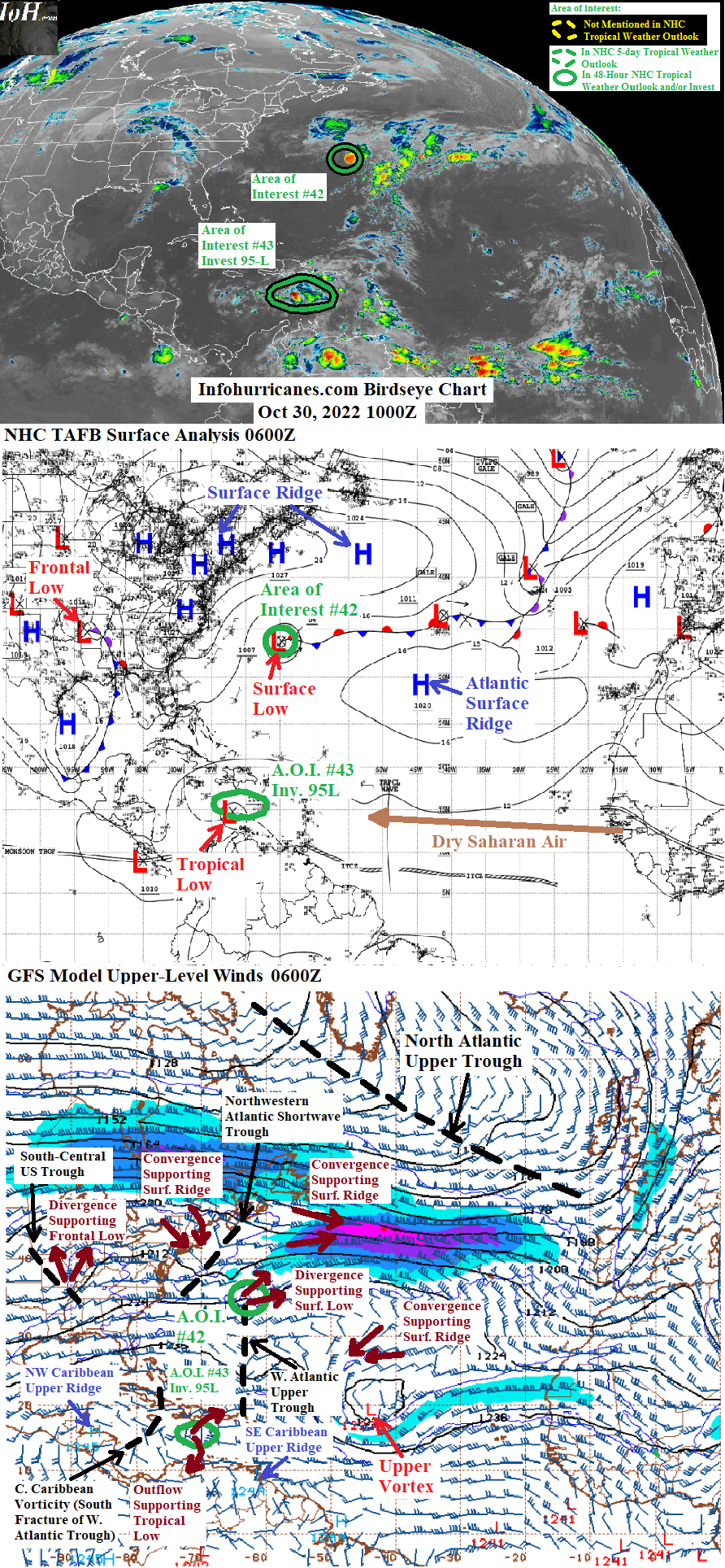
See area of interest #42 section below for an update on the subtropical low pressure area now positioned just northeast of Bermuda. See area of interest #43 section below for an update on the currently slow-moving Caribbean Sea tropical disturbance which appears to be developing a consolidating circulation to the northwest. Based on the current position of the new circulation and favorable upper-level wind outlook that lies ahead for this disturbance... the potential for impacts to Jamaica... the north coast of Honduras... and possibly southern Belize is increasing.
Elswehere... upper troughing is expected to increase over the next couple of days and across the southeastern United States as the current south-central US upper trough merges with the south portion of the current upper trough approaching from the western US. In approximately five days... this upper troughing is expected to shift into the western Atlantic... with split flow upper divergence between upper westerlies on the south side of the upper trough and upper northeasterlies on the southeast side of the current northwestern Caribbean upper ridge cell expected to increase over the southern Caribbean Sea. Models are coming into increasing agreement that an additional tropical low pressure disturbance could form in the southern Caribbean in response to the split flow upper divergence in 5+ days... an additional area of interest could be declared in the southern Caribbean in future updates if these trends continue.
New to this site this year... I will be sequentially numbering up areas of interest for possible Atlantic tropical development. In this scheme... will reset back to #1 at the start of next year (January 2023). The current area of interest in this blog post are designated #42 and #43 as the other numbers were used in previous birdseye view posts. This scheme is to reduce confusion as Atlantic tropical activity increases during the peak of the hurricane season... when multiple simultaneous areas of interest begin and end which previously required shuffling around the area of interest numbers from update to update.
AREA OF INTEREST #42... The subtropical low pressure area in the vicinity of Bermuda has continued northeast and has recently passed just north of the island. As of this writing the associated surface swirl is now accelerating east and is positioned just northeast of the island. A few model runs such as this past 1200Z ECMWF suggested that the subtropical surface low could become stationary while becoming invigorated by the divergence zone of the incoming shortwave upper trough to the northwest. However the low-level cloud motion in the latest nighttime infrared satellite imagery suggests a separate area of cyclonic motion increasing to the west-northwest of the subtropical low pressure's swirl and induced by the divergence zone of the shortwave upper trough... therefore it appears likely that the subtropical low pressure will instead become elongated in the next 24 hours while the swirl now northeast of Bermuda merges with the area of dropping surface pressures to the west-northwest. This elongation is what the majority of recent model runs have been forecasting... with the elongated structure making it challenging for subtropical cyclone formation to occur going forward. Wind shear will also tend to be excessive for subtropical development as the low amplitude nature of the incoming shortwave upper trough will produce excess upper westerly flow. Therefore in this update I have dropped odds of subtropical cyclone formation to 0%... and plan this to be my final statement on this area of interest on this blog.
******Infohurricanes.com outlook. Visit hurricanes.gov (hurricanes dot gov) for official outlook***********
IOH 24 Hr Outlook (0600Z Oct 31)...0% chance of subtropical cyclone formation (east-northeast of Bermuda near 34.5N-61.5W)
AREA OF INTEREST #43... The previously disorganized surface trough of low pressure in the eastern Caribbean Sea has developed a better-defined surface cyclonic circulation to the northwest... near 15N-72W as of this writing. When studying the upper-level winds across the Caribbean... an upper ridge cell is spotted over the northwestern Caribbean after being pushed from Central America by the current south-central US upper trough while an upper ridge cell from the southeastern Caribbean is expanding in the wake of the current western Atlantic upper trough as that trough is now weakening while it has remained isolated from high-latitude cold air. In between the two upper ridge cells... a southern chunk of the western Atlantic upper trough has become trapped in between and in the central Caribbean as a weak area of upper vorticity. It is probable that the better defined northwestern surface circulation has formed with the support of upper divergence between the east side of the weak area of upper vorticity and northwest side of the southeastern upper ridge cell... and this could be what the northern solution model runs in previous days were picking up on. Because I had previously projected the outflow of the southeastern upper ridge cell would generate a consolidated surface circulation to the southeast... this means I have made a notable northwestward adjustment in the track forecast in this update cycle.
The consolidating low pressure spin near 15N-72W is expected to continue west across the Caribbean Sea... at first slowly over the next 24 hours due to the surface ridge weakness associated with area of interest #42. There are a couple of factors that favor a westward track as follows:
(1) The current northwestern Caribbean upper ridge cell whose south side will promote an ongoing westward track if this system were to become stronger/taller to couple with upper flow.
(2) Upper troughing is expected to increase over the southeastern US during the forecast period... a merger between the current south-central US upper trough and the south part of yet another upper trough that is currently sliding across the western US. The western convergence zone of the upper troughing is expected to build a surface ridge over the eastern US and Gulf of Mexico. The surface ridge will recover the steering surface easterly trade winds in the Caribbean... the forecast track in the outlook below shows an increasing forward speed at 2+ days as a reflection of the recovering trades. A south bend in the forecast track by 4+ days is a reflection of the forecast strength of the surface ridge expected during that timeframe.
Regarding odds of tropical cyclone formation... the NHC has retained a 70% peak by day 5. Because a surface circulation is becoming better defined as noted above... I have raised my peak odds of tropical cyclone formation to 60%... as the surface circulation is still relatively new and its associated thunderstorm activity has not become well organized so far. However will be raising odds of development further in future updates should this system become better organized. The area of disrputing central Caribbean upper vorticity is also weaker than previously projected and is now forecast to dissipate sooner in the latest model runs... raising the possiblity that this system develops earlier and also near Jamaica. Odds of development are dropped to 0% by day 5 due to forecast land interaction... as the southward-bending westward track is expected to bring this system into Honduras or southern Belize.
Regarding the impact to land areas:
(1) Due to the northwestward consolidation of the spin along the surface trough associated with this disturbance... the ABC Islands (Aruba Bonaire and Curacao)... northwest coast of Venezuela... and the Guajira peninsula of northern Colombia no longer have potential to see notable weather from this system.
(2) As discussed above... upper-level wind conditions near Jamaica are expected to be more conducive for tropical development than previously forecast. Combined with the current more northwest position of this disturbance... there is more potential for heavy rainfall from this disturbance by Monday evening. The potential for gusty winds appears low as the new circulation of this disturbance will need time to develop and the center of circulation is currently expected to pass south of instead of directly over the island.
(3) Interests along the north coast of Honduras and south coast of Belize should be aware of this system for possible tropical cyclone impacts (wind... rain... and coastal surf) as it has potential to track toward the region under improving upper-level wind conditions in 4+ days.
******Infohurricanes.com outlook. Visit hurricanes.gov (hurricanes dot gov) for official outlook***********
IOH 24 Hr Outlook (0600Z Oct 31)... 30% chance of tropical cyclone formation (south of Haiti near 16N-74W)
IOH 48 Hr Outlook (0600Z Nov 1)... 50% chance of tropical cyclone formation (south of Jamaica near 16N-77.5W)
IOH 72 Hr Outlook (0600Z Nov 2)... 60% chance of tropical cyclone formation (western Caribbean near 16N-81.5W)
IOH 96 Hr Outlook (0600Z Nov 3)... 60% chance of tropical cyclone formation (northeast coast of Honduras near 15.5N-85W)
IOH 120 Hr Outlook (0600Z Nov 4)... 0% chance of tropical cyclone formation (central Honduras near 14.8N-87.5W)
...COMPUTER MODEL SUMMARY...
Source...Florida State University Experimental Forecast Tropical Cyclone Genesis Potential Fields (http://moe.met.fsu.edu/tcgengifs/)
0000Z (Oct 30) CMC Model Run...
**For area of interest #42... surface low passes just north of Bermuda over next 6 hours after which time it becomes less tropical and more elongated... further elongation causes transition to mid-ocean cold front near 31.5N-49W at 120 hours
**For area of interest #43... tropical low forms near 15N-71.5W at 6 hours... center of tropical low passes just south of Jamaica at 42 hours... tropical cyclone formation suggested south of the Cayman Islands near 17.5N-80.5W at 60 hours... after additional strengthening makes landfall as a compact tropical cyclone on the coast of Belize at 102 hours... weakens to a remnant low that moves into northern Guatemala at 120 hours
1200Z (Oct 29) ECMWF Model Run...
**For area of interest #42... surface low passes just north of Bermuda over next 18 hours... becoms stationary at this location while strengthening through 36 hours with support of divergence maximum of incoming shortwave upper trough to the northwest... subsequently surface low moves east-southeast while weakening and becoming less tropical and more elongated... becomes absorbed by developing non-tropical low to the northeast while located near 30.2N-56W at 102 hours.
**For area of interest #43... tropical low forms near 14.8N-71.5W at 18 hours... becomes a tropical depression offshore of the north Honduras coast and near 16.5N-86.2W at 102 hours... makes landfall over southern Belize at 114 hours... with inland remnant low dissipating over east-central Guatemala at 120 hours.
0000Z (Oct 30) GFS Model Run...
**For area of interest #42... surface low passes just north of Bermuda over next 6 hours after which time it becomes less tropical and more elongated but also strengthens while supported by divergence maxium of incoming shortwave upper trough to the northwest... becomes absorbed by developing non-tropical low to the northeast while located near 36N-46W at 102 hours.
**For area of interest #43... tropical low forms near 15N-72.5W at 12 hours... passes just south of Jamaica at 60 hours... becomes a tropical depression between the Cayman Islands and Honduras near 17N-83.8W at 81 hours...tropical depression moves west-southwest into southern Belize at 111 hours... inland remnant low dissipates over central Guatemala at 123 hours.
**Upper troughing increases over the southeastern US as current upper trough over the south-central US merges with south side of additional upper trough that moves across North America through 63 hours... upper troughing moves offshore into western Atlantic through 126 hours with split flow upper divergence between the south side of the upper troughing and east side of Caribbean upper ridging produces a southern Caribbean tropical low near 11.5N-80.1W... tropical cyclone formation suggested offshore of the Nicaragua/Costa Rica border and near 11.2N-81W at 138 hours.
0000Z (Oct 30) NAVGEM Model Run...
**For area of interest #42... surface low passes just north of Bermuda over next 6 hours after which time it becomes less tropical and more elongated... remnant non-tropical low continues east and reaches 36N-50W at 90 hours... high-latitude north Atlantic amplified upper trough accelerates the remnant non-tropical low northeastward with its eastern divergence zone intensifying the non-tropical low into a frontal cyclone which reaches 49N-31.5W at 120 hours
**For area of interest #43... initialized as a tropical low at 0 hours... passes just south of Jamaica at 54 hours... weakens to a trough southwest of Jamaica at 66 hours... redevelops into a tropical low near 17.5N-83.5W at 84 hours... makes landfall over southern Belize at 120 hours while weakening back to a trough
**Upper troughing increases over the southeastern US as current upper trough over the south-central US merges with south side of additional upper trough that moves across North America through 66 hours... upper troughing moves offshore into western Atlantic through 120 hours with split flow upper divergence between the south side of the upper troughing and east side of Caribbean upper ridging produces a southern Caribbean tropical low near 12.5N-79.5W... tropical cyclone formation suggested offshore of southern Nicaragua and near 12N-80.5W at 138 hours.


Comments