MY 2022 ATLANTIC HURRICANE SEASON BIRDSEYE VIEW POST #132
- NCHurricane2009

- Oct 18, 2022
- 4 min read
*******Note that forecast and outlooks in this post are NOT the official forecast from the National Hurricane Center (NHC). They are my own detailed views on the Atlantic tropics based on current observations and latest computer model runs. As such do not make decisions based on my posts...consult news media...watches and warnings from your local weather office...and any evacuation orders issued by local governments to make the most informed and best decisions. Visit the NHC website hurricanes.gov (hurricanes dot gov) for the latest watches/warnings and official forecasts on active tropical cyclones.**********
...TUESDAY OCTOBER 18 2022 3:35 AM EDT...
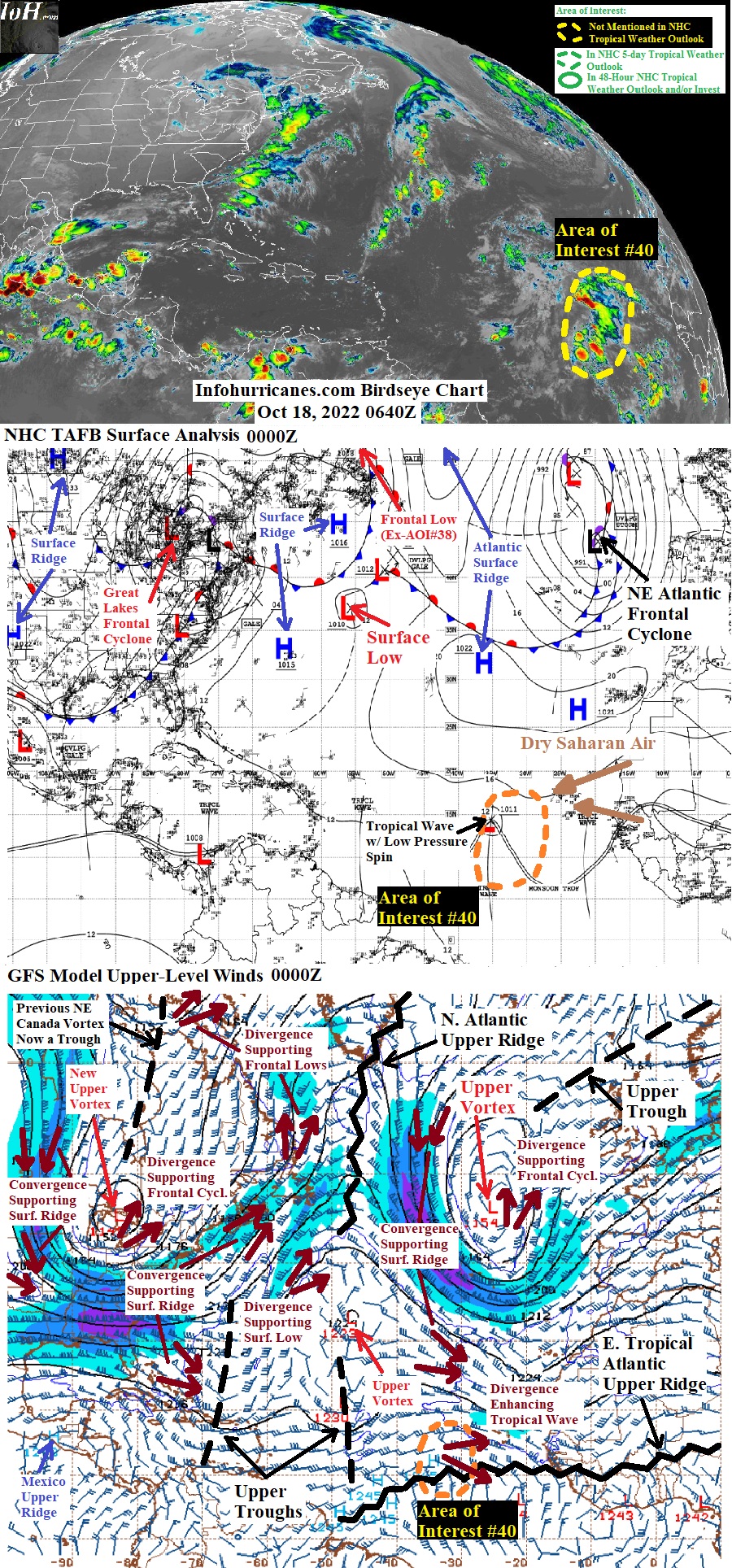
See area of interest #40 section below for an update on the eastern Atlantic tropical wave of low pressure in the vicinity of 35W longitude. Elsewhere... the eastern divergence zone of an upper trough in the vicinity of Bermuda is producing a surface low near 37N-55.5W. This system is expected to continue eastward into the open central Atlantic over the next few days... and then stall in this region while becoming cut-off from the mid-latitude westerlies by a warm core upper ridge to build to the north while bolstered by warm southerly flow to occur on the east side of a sprawling Canadian frontal cyclone that is currently forecast to develop. While cut-off and stalled in the open central Atlantic... this system has potential to evolve into a deep-layered low pressure system parked over warm enough waters to acquire tropical characteristics. Currently not upgrading this system as an area of interest for tropical development on this blog as model runs have not been consistent on whether or not the deep-layered low pressure system will be circular/consolidated enough to transition into a subtropical cyclone. Should later model runs trend in this direction or if observations later warrant... this system will be introduced as an area of interest in future updates.
New to this site this year... I will be sequentially numbering up areas of interest for possible Atlantic tropical development. In this scheme... will reset back to #1 at the start of next year (January 2023). The current area of interest in this blog post is designated #40 as the other numbers were used in previous birdseye view posts. This scheme is to reduce confusion as Atlantic tropical activity increases during the peak of the hurricane season... when multiple simultaneous areas of interest begin and end which previously required shuffling around the area of interest numbers from update to update.
AREA OF INTEREST #40... For the eastern Atlantic tropical wave of low pressure that has been in the vicinity of 35W longitude... the 0000Z NHC TAFB surface analysis suggests that the wave has seen an increase in surface vorticity (spin) toward the north while analyzing a surface low pressure spin along the wave axis and toward 15N latitude. The CIMSS 850 mb vorticity product (https://tropic.ssec.wisc.edu/real-time/windmain.php?basin=atlantic&sat=wg8&prod=vor&zoom=&time=) suggests the wave has also maintained its original further south area of spin toward 11N latitude... resulting in an elongated area of rotation from 11N to 15N latitude. Also noting the wave has been stationary around 35W longitude over the last 24 hours while transitioning into a feature enhanced by a maximal area of upper divergence on the east side of a low-latitude upper trough approaching from 50W longitude. However the forecast track in the outlook below still shows the wave reaching 41W longitude in the next 24 hours as models still bring the wave to this location during this forecast timeframe (I have also nudged the forecast track northward as the centroid of spin is now further north due to the recent expansion of spin toward 15N latitude). Although wind shear may relax in the next 24 hours as the low-latitude upper trough weakens while remaining cut-off from high-latitude cold air... the window of lowered shear will be short-lived as the upper trough currently near Bermuda will approach. And given the wave has an elongated instead of consolidated area of spin as noted above... the window of low shear will likely be too short-lived to give time for the elongated spin to consolidate and therefore I have dropped tropical cyclone formation odds for this area of interest to 0%. This is my planned final statement on this area of interest on this blog.
******Infohurricanes.com outlook. Visit hurricanes.gov (hurricanes dot gov) for official outlook***********
IOH 24 Hr Outlook (0600Z Oct 19)... 0% chance of tropical cyclone formation (central tropical Atlantic near 13.5N-41W)
...COMPUTER MODEL SUMMARY...
Source...Florida State University Experimental Forecast Tropical Cyclone Genesis Potential Fields (http://moe.met.fsu.edu/tcgengifs/)
1200Z (Oct 17) CMC Model Run...
**For area of interest #40... no development shown
1200Z (Oct 17) ECMWF Model Run...
**For area of interest #40... no development shown
0000Z (Oct 18) GFS Model Run...
**For area of interest #40... no development shown
**From 30 to 87 hours the Great Lakes frontal cyclone and its upper vortex merge with additional upper troughs/surface lows over western and central Canada to produce a sprawling frontal cyclone across much of Canada while the southern portion of the Great Lakes upper vortex moves into the western Atlantic offshore of the southeastern US where it produces an inverted surface trough over the central Bahamas... warm sector of sprawling Canadian frontal cyclone and an additional frontal cyclone that moves into the western US subsequently builds an eastern US to northwest Atlantic upper ridge that causes the smaller upper vortex/inverted surface trough offshore of the southeastern US to evolve into a cut-off deep-layered low pressure system with potential tropical characteristics near 26.5N-76W at 153 hours.
1800Z (Oct 17) NAVGEM Model Run...
**For area of interest #40... no development shown
**Upper trough in vicinity of Bermuda and associated surface low moves east to vicnity of 32.5N-42.5W at 66 hours... warm sector of sprawling Canadian frontal cyclone subsequently builds central Atlantic upper ridge which in turn cuts-off the upper trough/surface low near 32.5N-42.5W into a westward-retrograding deep-layered low pressure system after 66 hours... at 84 hours the surface layer of the deep-layered low merges with north end of tropical wave associated with AOI #40 which results in a large inverted surface trough near 44W longitude... north end of inverted surface trough evolves into a surface low near 27.5N-44W at 120 hours.


Comments