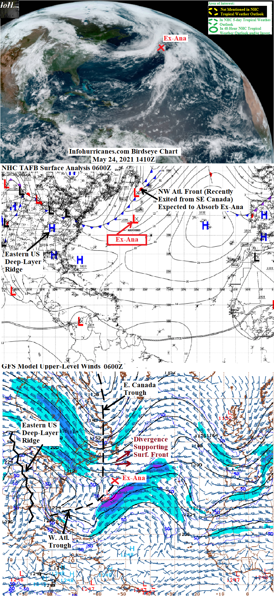
MY 2021 ATLANTIC HURRICANE SEASON BIRDSEYE VIEW POST #6
- NCHurricane2009

- May 24, 2021
- 3 min read
*******Note that forecasts and outlooks in this post are NOT the official forecast from the National Hurricane Center (NHC). They are my own detailed views on the Atlantic tropics based on current observations and latest computer model runs. As such do not make decisions based on my posts...consult news media...watches and warnings from your local weather office...and any evacuation orders issued by local governments to make the most informed and best decisions. Visit the NHC website hurricanes.gov (hurricanes dot gov) for the latest watches/warnings and official forecasts on active tropical cyclones.**********
...MONDAY MAY 24 2021 11:50 AM EDT...

Tropical depression Ana in the open northwest Atlantic has degenerated into a remnant low while continuing to lack thunderstorms...see Remnants of Ana section below for additional details.
Elsewhere...warm deep-layer ridging is expected to persist over central and eastern North America over the next several days...with the amplified ridge potentially causing mid-latitude upper troughs to amplify into cut-off upper vortices in the western Atlantic...providing potential zones of low shear and upper-level divergence for subtropical or tropical activity. The first such upper vortex is expected in 2 to 4 days at a location southwest of Bermuda from energy to be left behind by the current western Atlantic upper trough and upper trough soon to exit from eastern Canada. Around day 4 the current western US upper trough may add to the forecast western Atlantic upper vortex or become its own vortex at a location to the west...and in about a week's time the current upper trough offshore of the northwest US may produce cut-off upper vorticity offshore of the eastern US. However...currently none of the computer models forecast tropical cyclone formation over the next few days in response to these forecast features...therefore this is my final birdseye view post until the hurricane season officially starts June 1st...or unless observations or computer model runs suggest possible Atlantic tropical cyclone development before then.
REMNANTS OF ANA...Tropical Depression Ana did not regain thunderstorms since the previous update as the overhead cut-off upper trough has continued to warm while remaining cut-off from high latitude cold air...reducing the instability (upper-level 200 mb heights over Ana have risen/warmed to above 1200 dekameters...would like to see below 1200 dekameters for the low-20 deg C water temps Ana is over). As a result...the National Hurricane Center has downgraded Ana to a remnant surface low pressure effective 11 PM EDT last night. The remnant low is moving east-northeast out ahead of a cold front that has recently entered the northwest Atlantic...and will be absorbed by the front within the next 24 hours. This is my final statement on Ana on this blog.
...COMPUTER MODEL SUMMARY...
Source...Florida State University Experimental Forecast Tropical Cyclone Genesis Potential Fields (http://moe.met.fsu.edu/tcgengifs/)
0000Z CMC Model Run...Tail end of current northwest Atlantic front evolves into surface low over Bermuda in 42 hours with support of developing cut-off upper vortex...however no tropical cyclone formation shown as upper-level temps too warm to support instability with water temps in the low-20 deg C range.
0000Z ECMWF Model Run...Tail end of current northwest Atlantic front evolves into surface low just southeast of Bermuda in 48 hours with support of developing cut-off upper vortex...however no tropical cyclone formation shown as upper-level temps too warm to support instability with water temps in the low-20 deg C range.
0600Z GFS Model Run...Tail end of current northwest Atlantic front evolves into surface trough just southeast of Bermuda in 54 hours with support of developing cut-off upper vortex...however no tropical cyclone formation shown as upper-level temps too warm to support instability with water temps in the low-20 deg C range.
0600Z NAVGEM Model Run...Tail end of current northwest Atlantic front evolves into surface trough east-southeast of Bermuda in 54 hours with support of developing cut-off upper vortex...however no tropical cyclone formation shown as upper-level temps too warm to support instability with water temps in the low-20 deg C range. Elsewhere...tropical low shown forming in southern Caribbean at 144 hours near 11N-78.5W


Comments