MY 2020 ATLANTIC HURRICANE SEASON BIRDSEYE VIEW POST #79
- NCHurricane2009

- Aug 2, 2020
- 6 min read
*******Note that forecasts and outlooks in this post are NOT the official forecast from the National Hurricane Center (NHC). They are my own detailed views on the Atlantic tropics based on current observations and latest computer model runs. As such do not make decisions based on my posts...consult news media...watches and warnings from your local weather office...and any evacuation orders issued by local governments to make the most informed and best decisions. Visit the NHC website hurricanes.gov (hurricanes dot gov) for the latest watches/warnings and official forecasts on active tropical cyclones.**********
...SUNDAY AUGUST 2 2020 7:30 PM EDT...
See Tropical Storm Isaias section below for the only active tropical cyclones in the Atlantic basin. See area of interest section below for the central Atlantic tropical wave of low pressure being monitored for development.
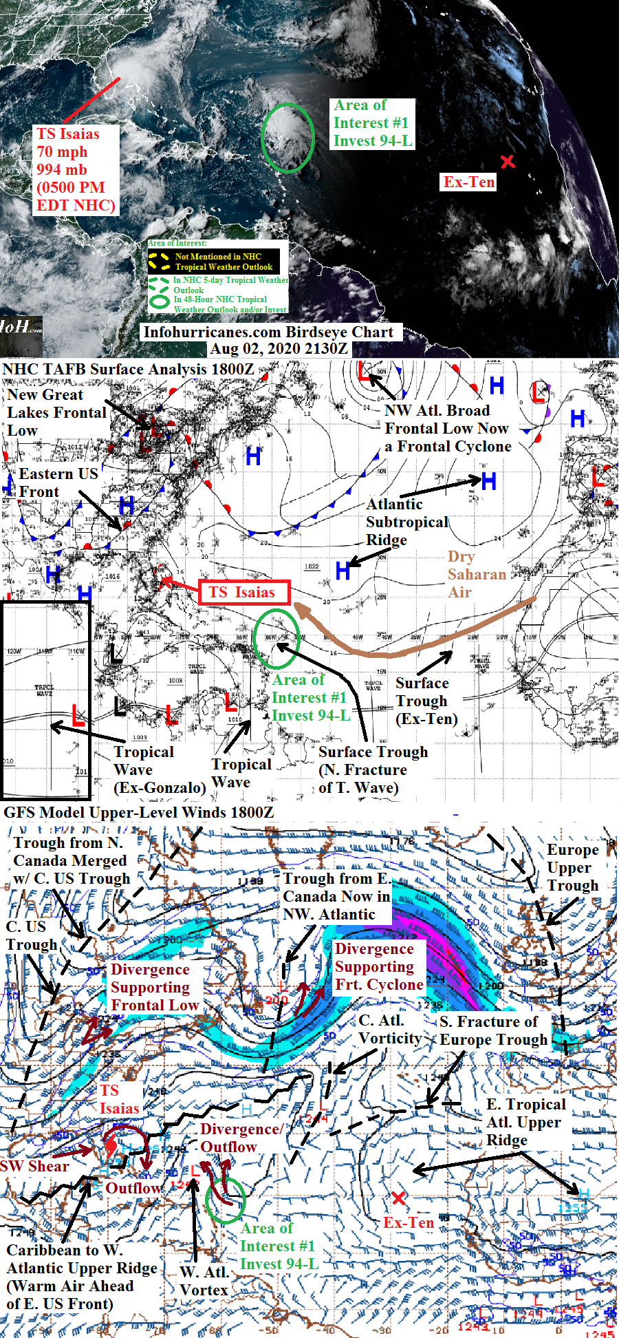
TROPICAL STORM ISAIAS...Isaias has finally curved northward in track just east of 80W longitude...and just offshore of the east Florida coast...while the eastern divergence zone of the approaching upper trough from the central United States has eroded the west side of the steering Atlantic subtropical surface ridge. This same upper trough is shearing the heaviest thunderstorms to the northeast of the center...thus keeping the rainfall and gusty winds on the Florida east coast minimal. A similar story is expected for the Georgia coast through tomorrow...but large waves and coastal sea swells will be a concern along the Florida and Georgia coast. The shear had slightly weakened Isaias to 65 mph maximum sustained winds...but most recently maximum sustained winds have climbed back up to 70 mph.
I have nudged my updated forecast points to be south of my previous as Isaias reached 27.5N latitude instead of 28N latitude around 2 PM (1800Z) this afternoon. Regarding intensity...I am continuing my previous forecast where Isaias is at 70 mph maximum sustained winds for much of its remaining life cycle. Even though the circulation will be interacting with land from the Carolinas to the northeastern United States...I keep this intensity through 48 hours as Isaias will remain supported by divergence on the east side of the incoming upper trough...and the east side of the circulation will likely remain over 26+ deg C waters that extend all the way unusually far north to the New Jersey coast...thus I do not think it will lose tropical characteristics before 48 hours...espeically as the cold front being driven by the upper trough will still be off to the west. I will note it wouldn't suprise me if Isaias regained hurricane status on the way to the eastern Carolinas in the next 24 hours as the incoming central United States upper trough has become more amplified while being injected with cooler air from a higher-latitude Canadian upper trough phasing with it...thus the upper wind flow ahead of the upper trough is becoming increasingly southerly and more aligned with the forward motion of the storm...thus reducing the shear that has been negatively affecting Isaias. I continue to show a lower intensity at the end of the forecast period (72 hours) as models still show the more amplified upper trough generating a seperate frontal low pressure center west of Isaias that will be the dominant non-tropical feature in the region (before Isaias was supposed to transition to the dominant non-tropical feature). Thus wind impacts across New Brunswick...Nova Scotia...and Prince Edward Island by Wednesday may not be as high as previously thought.
See bulletins at the home page of this site for additional details on the expected impacts of Isaias. Due to the COVID-19 virus emergency ongoing across the southern United States....if you must retreive last minute storm preparation supplies in the eastern Carolinas in a crowded setting...wearing a mask and frequent hand sanitizing will reduce your risk of contracting COVID-19. Also I would suggest thinking about the use of a family/friend residence or hotel location further inland if you live in an area prone to coastal storm surge in case you may have to relocate as the storm approaches and details of exact impacts become clearer...as a public shelter may not be as ideal for controlling your exposure to COVID-19.
******Infohurricanes.com forecast. Visit hurricanes.gov (hurricanes dot gov) for official forecast***********
0 Hr Position (1800Z Aug 2)...65 mph maximum sustained wind tropical storm centered just offshore of east-central Florida at 27.4N-79.7W
IOH 24 Hr Forecast (1800Z Aug 3)...70 mph maximum sustained wind tropical just offshore of the South Carolina coast at 32N-79.5W
IOH 48 Hr Forecast (1800 Aug 4)...70 mph maximum sustained wind tropical storm centered just offshore of southern New Jersey and Delaware at 39N-74.8W
IOH 72 Hr Forecast (1800Z Aug 5)...Remnant frontal low centered over New Brunswick just east of the Maine border at 46.5N-67W
AREA OF INTEREST #1...The north end of a central Atlantic broad tropical wave of low pressure has fractured into a seperete surface trough of low pressure with organizing rotating thunderstorms at a location just northeast of the Lesser Antilles islands...located in the vicinity of 20N-60W. This development is due to supportive divergence on the southeast side of a cut-off upper vortex to the northwest. The warm upper ridge in the western Atlantic is expected to push the upper vortex westward and away and overspread this disturance...which will keep upper winds quiet favorable for development by keeping wind shear low and upper outflow high. Due to this outlook and increasing organization...I have raised my peak odds of development to 75%. I would have gone with a tropical cyclone formation forecast...but have backed off from doing so as interestingly the computer models have backed off in showing this system develop despite the current organization. By 72+ hours...I nudge odds of development downward as the upper trough forecast to recurve Tropical Storm Isaias north and northeast merges with the upper vortex while keeping the vortex pushed toward the disturbance...which will likely begin to increase some wind shear. Forecast track of this disturbance is initially straightfoward...a west-northwest to northwest trajectory around the southwest side of the Atlantic surface subtropical ridge. The forecast track keeps this system away from land areas...passing between the Caribbean Islands and Bermuda...and offshore of the eastern United States. The forecast track becomes a little murky by 120 hours as the upper trough that recurves Isaias passes to the north...with its western convergence zone producing another surface ridge over the Great Lakes region of North America potentially stalling the northwest track of this disturbance.
******Infohurricanes.com outlook. Visit hurricanes.gov (hurricanes dot gov) for official outlook***********
IOH 24 Hr Outlook (1800Z Aug 3)...55% chance of tropical cyclone formation (western Atlantic near 22N-65W)
IOH 48 Hr Outlook (1800Z Aug 4)...75% chance of tropical cyclone formation (western Atlatnic near 25N-70W)
IOH 72 Hr Outlook (1800Z Aug 5)...45% chance of tropical cyclone formation (western Atlantic near near 31N-72W)
IOH 96 Hr Outlook (1800Z Aug 6)...35% chance of tropical cyclone formation (western Atlantic near 34N-72W)
IOH 120 Hr Outlook (1800Z Aug 7)... 35% chance of tropical cyclone formation (western Atlantic near 36N-72W)
...COMPUTER MODEL SUMMARY...
Source...Florida State University Experimental Forecast Tropical Cyclone Genesis Potential Fields (http://moe.met.fsu.edu/tcgengifs/)
1200Z CMC Model Run...For Tropical Storm Isaias...shown to make landfall on the central South Carolina coast in 36 hours...weakens to a tropical storm on the south Florida peninsula through 36 hours...moves across the eastern Carolinas and southeast Virginia through 48 hours...moves across eastern Maryland & Delaware & into moves into southwestern New Jersey by 54 hours...moves over New York City by 60 hours...moves across Vermont and New Hampshire in 66 hours...while moving across New Brunswick in 78 hours quickly weakens and loses its identity to frontal low pressure to the west. For area of interest #1...no tropical cyclone formation shown. Elsewhere...tropical wave currently near 20W develops into surface low near 35W in 48 hours...tropical cyclone formation shown near 10N-37.5W in 78 hours...tropical cyclone shown near 13N-45W in 120 hours.
0000Z ECMWF Model Run...For Tropical Storm Isaias...makes landfall near the South Carolina/Georgia border just after 48 hours, moves rapidly north-northeast and reaches southwestern New Jersey by 72 hours...weakens considerably by 96 hours while over New Brunswick as frontal low pressure to the northwest dominates. For area of interest #1...north end of broad tropical wave of low pressure fractures into a seperate surface trough in the western Atlantic near 26N-66W in 48 hours...develops into a surface low near 30N-68W in 72 hours...dissipates west of Bermuda by 120 hours.
1200Z GFS Model Run...For Tropical Storm Isaias...makes landfall in northeastern South Carolina in 36 hours...moves across eastern North Carolina and southeast Virginia through 48 hours...reaches southern New Jersey in 54 hours...centered over Vermont & New Hampshire in 60 hours...begins weakening over Maine 66 hours...continues to weaken over New Brunswick in 78 hours...loses identity west of Newfoundland in 90 hours. For area of interest #1...north end of broad tropical wave of low pressure fractures into a seperate small surface low north of the Virgin Islands near 21.5N-64W in 24 hours...becomes stalled near 29N-70W from 66 to 120 hours.
1200Z NAVGEM Model Run...For Tropical Storm Isaias...strengthens into an intense hurricane and makes landfall over Cape Fear North Carolina in 48 hours...reaches waters just offshore of New Jersey in 66 hours...over Cape Cod Massachusetts in 72 hours...moves into New Brunswick in 84 hours while still at high strength...moves into south coast of Quebec in 108 to 120 hours while still at gale force. For area of interest #1...north end of tropical wave fractures into separate surface trough of low pressure near 26N-69W in 42 hours...becomes surface low near 27.5N-69W in 48 hours...dissipates just west of Bermuda in 78 hours.


Comments