MY 2020 ATLANTIC HURRICANE SEASON BIRDSEYE VIEW POST #45
- NCHurricane2009

- Jun 27, 2020
- 3 min read
*******Note that forecasts and outlooks in this post are NOT the official forecast from the National Hurricane Center (NHC). They are my own detailed views on the Atlantic tropics based on current observations and latest computer model runs. As such do not make decisions based on my posts...consult news media...watches and warnings from your local weather office...and any evacuation orders issued by local governments to make the most informed and best decisions. Visit the NHC website hurricanes.gov (hurricanes dot gov) for the latest watches/warnings and official forecasts on active tropical cyclones.**********
...SATURDAY JUNE 27 2020 10:17 AM EDT...

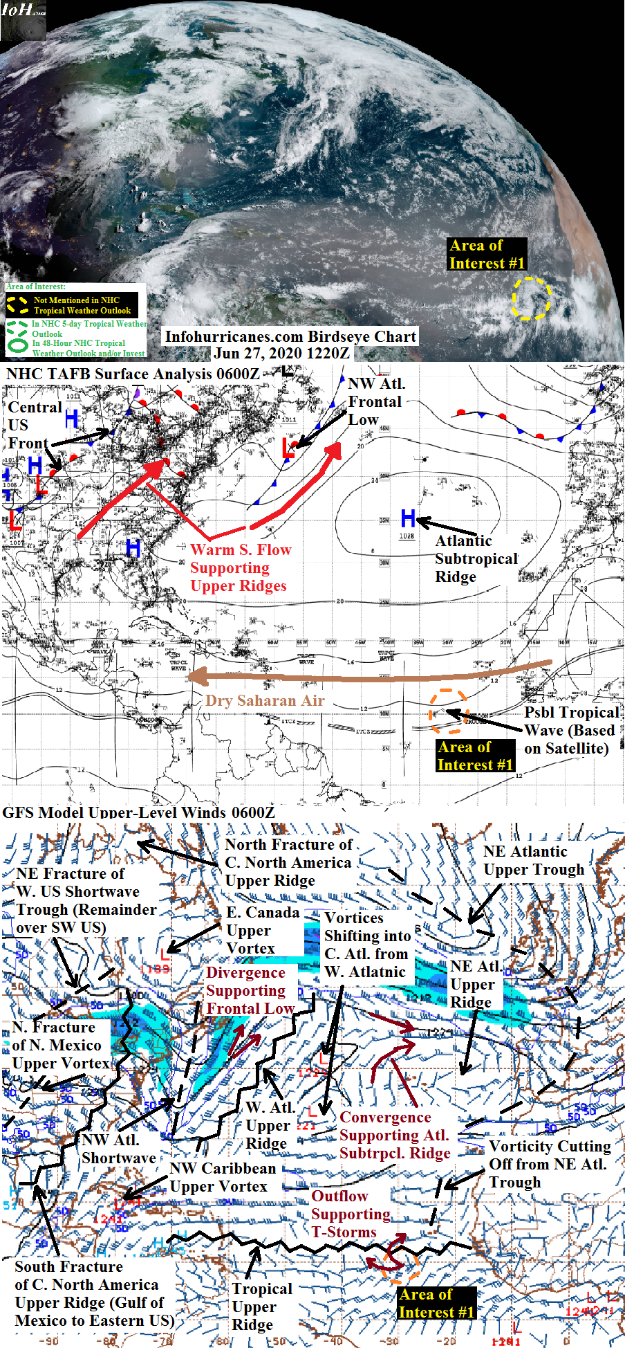
See area of interest section below for a tropical wave in the eastern tropical Atlantic that I am monitoring for tropical cyclone formation. Elsewhere...the north fracture of a shortwave upper trough from the western United States has arrived over the north-central United States and south-central Canada...and is driving a surface cold front across the central United States. The shortwave is expected to soon merge with the eastern Canada upper vortex while the front arrives into the western Atlantic in 48 hours. The upper ridging out ahead of the front and currently over the eastern United States will arrive into the western Atlantic and potentially provide upper winds favorable to tropical development as the south part of the front slips beneath it. However computer models have trended in showing a non-tropical low pressure developing further north along the front to be supported by the eastern Canada upper vortex. The only exception might be the 0000Z ECMWF model run from this morning which shows a surface low pressure forming further southeast compared to the rest of the model guidance. Given the day-to-day inconsistency in the model runs...I have not declared this frontal zone an area of interest for tropical development at this time.
AREA OF INTEREST #1...A tropical wave of low pressure in the eastern tropical Atlantic continues to show some signs of organization...with the showers and thunderstorms wrapping around a center of rotation that appears to be near 10N-30W. The Atlantic surface subtropical ridge is forecast to be strong...which should keep the tropical wave moving briskly westward with little northward angle in its track...perhaps giving the tropical wave a chance to develop just south of the dry saharan air outbreak the lies to the north. But given that the dry saharan air outbreak has been very impressive...and that the intensity of the thunderstorm activity is less than yesterday...and also the loss of computer model support showing development...I have reduced my odds of tropical cyclone formation to 5% despite the tropical wave being below a cell of tropical upper ridging during the forecast period which would promote low wind shear and upper outflow that are otherwise favorable for development. This expansive cell of upper ridging will be between upper vorticity that cuts-off from the current northeastern Atlantic upper trough and the upper vorticity currently in the central Atlantic. I drop odds of development to 0% by 96 hours as the tropical wave is more likely to encounter shear from the central Atlantic upper vorticity by 96 hours or just after that timeframe.
******Infohurricanes.com outlook. Visit hurricanes.gov (hurricanes dot gov) for official outlook***********
IOH 24 Hr Outlook (1200Z Jun 28)...5% chance of tropical cyclone formation (tropical Atlantic near 10N-37.5W)
IOH 48 Hr Outlook (1200Z Jun 29)...5% chance of tropical cyclone formation (tropical Atlantic near 11N-45W)
IOH 72 Hr Outlook (1200Z Jun 30)...5% chance of tropical cyclone formation (tropical Atlantic near 12N-52W)
IOH 96 Hr Outlook (1200Z Jul 1)...0% chance of tropical cyclone formation(east of the Lesser Antilles near 13N-57.5W)
...COMPUTER MODEL SUMMARY...
Source...Florida State University Experimental Forecast Tropical Cyclone Genesis Potential Fields (http://moe.met.fsu.edu/tcgengifs/)
0000Z CMC Model Run...For area of interest #1...no tropical cyclone formation shown. Elsewhere...central US front swings into west Atlantic by 48 hours...weak low pressure along front near 37.5N-68W by 96 hours that tracks northeastward into Nova Scotia by 114 hours.
0000Z ECMWF Model Run...For area of interest #1...no tropical cyclone formation shown...tropical wave in eastern Caribbean Sea by 120 hours. Elsewhere...central US front swings into west Atlantic by 48 hours...tiny low pressure either along or ahead of the front by 96 hours located northwest of Bermuda near 35N-67W that tracks rapidly north-northeast and begins losing its identity near 41N-62.5W by 120 hours.
0600Z GFS Model Run...For area of interest #1...no tropical cyclone formation shown. Elsewhere...central US front swings into west Atlantic by 48 hours...weak and broad low pressure along front offshore of the Carolinas by 96 hours near 33.5N-72.5W which moves north-northeastward and begins losing its identity south of Nova Scotia by 126 hours.
0000Z NAVGEM Model Run...For area of interest #1...no tropical cyclone formation shown. Elsewhere...central US front swings into west Atlantic by 48 hours...low pressure along front near 40N-61.5W by 78 hours that moves northeastward into Newfoundland by 102 hours.


Comments