MY 2020 ATLANTIC HURRICANE SEASON BIRDSEYE VIEW POST #124
- NCHurricane2009

- Sep 18, 2020
- 14 min read
*******Note that forecasts and outlooks in this post are NOT the official forecast from the National Hurricane Center (NHC). They are my own detailed views on the Atlantic tropics based on current observations and latest computer model runs. As such do not make decisions based on my posts...consult news media...watches and warnings from your local weather office...and any evacuation orders issued by local governments to make the most informed and best decisions. Visit the NHC website hurricanes.gov (hurricanes dot gov) for the latest watches/warnings and official forecasts on active tropical cyclones.**********
...FRIDAY SEPTEMBER 18 2020 2:35 PM EDT...
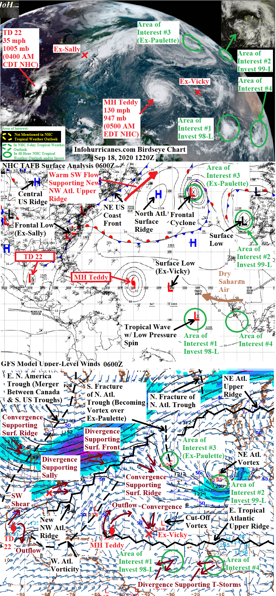
See Hurricane Teddy...Tropical Depression Twenty-Two...Tropical Storm Wilfred...and Subtropical Storm Alpha sections below for all four currently active tropical and subtropical cyclones in the Atlantic basin. See area of interest sections below for multiple disturbances being monitored for tropical or subtropical cyclone formation...one of which is the remnant circulation of Hurricane Paulette currently located just northwest of the Azores.
MAJOR HURRICANE TEDDY...After becoming a ferocious category 4 hurricane yeserday afternoon with 140 mph maximum sustained winds...Teddy has weakened slightly to 130 mph maximum sustained winds...but don't get me wrong this is still a ferocious hurricane. The hurricane has been moving northwestward while steered by and interacting with cut-off upper vorticity in the western Atlantic located north of the Caribbean islands. It appears the western outflow of Teddy was being blocked by this upper vorticity which may explain the slight weakening. As this vorticity weakens while remaining cut-off from higher latitude colder air and from Teddy's thunderstorm latent heat release...I forecast Teddy to strengthen into a higher-end category 4 hurricane in the next 24 hours. I forecast weakening toward a lower-end category 4 by day 2 as I assume an eye wall replacement cycle would have occurred by then...but it is impossible to actually know when such cycles will actually occur.
The biggest concern with Teddy is how it will affect Bermuda not long after Paulette already struck the island. As a powerful hurricane coupled to upper-level steering...at some point Teddy will be recurved northward in track due to the approach of the large upper trough currently over eastern North America. My short term forecast points remain identical to the previous forecast as Teddy has been on par with the older forecast and upper trough remains on track to catch Teddy soon enough to allow the hurricane to turn north just east of Bermuda instead of directly over the island. On this forecast...Bermuda will see coastal storm surge along with some potentially damaging tropical storm force winds caused by the western rain bands of Teddy by Monday....I recommend interests here to begin preparing for these impacts. I forecast further weakening to category 3 by 72 hours due to cooler waters that were upwelled by Paulette that Teddy would be passing over and increasing westerly shear as the large upper trough from the west approaches. Between 72 and 96 hours...the northerly surface flow on the west side of Teddy will amplify the cold core upper trough by pushing cold air southward...with increasing divergence on the east side of the amplifying upper trough in turn helping Teddy. This mechanism will make Teddy increasingly less tropical...but with the forecast amplification of the upper trough there will likely be a tremendous amount of upper divergence on the east side of the upper trough such that we are faced with Teddy transitioning into a powerful non-tropical frontal cyclone at category 1 or 2 hurricane force by 120 hours. With Teddy initially becoming a powerful hurricane roaming the western Atlantic...and then becoming a large powerful non-tropical cyclone with winds becoming further widespread by a pressure gradient between Teddy and a strengthening surface ridge to be supported by the western convergence zone of the amplifying upper trough...expect sea swells and rip currents to also reach the northeastern Caribbean Islands...the Bahamas...United States east coast...and Atlantic Canada coast over the next few days. In the longer range...my updated forecast track and computer model guidance have shifted northwestward and into the Nova Scotia region of Canada as another upper trough to pivot across North America was initially expected to be less amplified and guide Teddy and its amplifying upper trough eastward...but now the upper trough is forecast to be more amplified which will cause it to phase with the amplified upper trough to be interacting with Teddy...re-enforcing the amplified upper trough even further with more cold air such that the upper divergence zone of the upper trough will be even more tremendous which will keep Teddy's remnant frontal cyclone very strong...with the trough becoming so amplified it whirls Teddy northwestward. Therefore interests in eastern Maine...New Brunswick...Nova Scotia...Prince Edward Island...and Newfoundland are advised to also monitor the progress of Teddy for potentially damaging wind arriving by late Tuesday and Wednesday. If this forecast track verifies...the southerly and easterly onshore push of water on the east and north side of Teddy will cause coastal storm surge problems for parts of Nova Scotia...Prince Edward Island...Quebec...New Brunswick...and Newfoundland.
******Infohurricanes.com forecast. Visit hurricanes.gov (hurricanes dot gov) for official forecast***********
0 Hr Position (1200Z Sep 18)...130 mph maximum sustained wind major hurricane centered at 22.1N-56.1W
IOH 24 Hr Forecast (1200Z Sep 19)...145 mph maximum sustained wind major hurricane centered at 25N-59.5W
IOH 48 Hr Forecast (1200Z Sep 20)...135 mph maximum sustained wind major hurricane centered southeast of Bermuda at 29N-63W
IOH 72 Hr Forecast (1200Z Sep 21)...125 mph maximum sustained wind major hurricane centered just east of Bermuda at 31N-63W
IOH 96 Hr Forecast (1200Z Sep 22)...105 mph maximum sustained wind hurricane centered in the northwestern Atlantic at 37.5N-62W
IOH 120 Hr Forecast (1200Z Sep 23)...85 mph maximum sustained wind non-tropical remnant gale centered over Nova Scotia at 45N-63W
TROPICAL DEPRESSION TWENTY-TWO...The surface low pressure spin in the southwestern Gulf of Mexico became tropical depression twenty-two yesterday afternoon...but since then no strengthening has occurred as the circulation is stretched southwest-to-northeast instead of circular and focused where it can fire concentrated thunderstorms and intensify. This elongation is due to the arrival of a large upper trough over eastern North America which is also tilted southwest-to-northeast...and as such its eastern divergence zone maybe shaping the tropical depression's low pressure field.
As my previous forecast predicted...the depression has finally drifted northeastward toward the remant low pressure of Sally which is also supported by the eastern divergence zone of the large upper trough. It could also be argued that the strongest thunderstorms of the depression are sheared to the northeast half of the circulation by the upper trough's southwesterly winds...and thus the center of lowest surface pressure is reforming to the northeast closer to the thunderstorms as we sometimes see in sheared tropical systems that don't yet have a tight center. Going forward...my forecast assumes the current central United States surface ridge building under the western convergence zone of the large upper trough will begin to turn this system westward. However the motion is shown to be very slow as the western convergence zone of the southwestern lobe of the upper trough will extend the central United States surface ridge southwestward...with the southwestern lobe of the ridge blocking west progress. Because of this forecast southwestern lobe...I forecast zero forward speed from 24 to 48 hours. This southwestern surface ridge lobe finally may weaken by 72 to 120 hours...but I show only a very slow westward motion commencing as a second upper trough to pivot across Canada and the United States may still somewhat re-enforce the stubborn blocking southwestern lobe of the surface ridge with its southwestern convergence zone. But the modeling has shifted to showing the second upper trough being further north such that the southwestern surface ridge lobe may be gone entirely...so my updated forecast shows a slightly faster westward motion that brings this system over land by 96 hours. Therefore by 120 hours I am forced to predict this system becoming weaker and shallower from landfall such that it moves northwestward around the southwestern side of the central United States surface ridge. However if for any reason the system takes longer to make landfall and stays stronger/taller at a location along the coast or just offshore...that opens the door for a third upper trough to pivot into the southwestern United States that would try to push this system northeastward against the central United States surface ridge...creating an erratic and very slow northeastward track near or along the northeast Mexico and/or Texas coastline as the latest NHC official forecast and models currently show.
Regarding intensity...the depression is running out of time to strengthen in a low shear environment...as the shear has increased with the arrival of the large eastern North America upper trough. But the depression is just below tropical storm force...so in my updated forecast below I interpret that the depression could become a tropical storm shortly...and then weaken back down to tropical depression status by 24 hours. Once the current eastern North America trough and its unfavorable shear passes...I forecast strengthening to strong tropical storm status by 72 hours as all the models in the model summary below indicate quick strengthening once the shear drops. Even though there will be less shear from the second upper trough as it is now forecast to be further north...I forecast weakening to begin by 96 hours due to land interaction (thus my intensity at 72 and 96 hours looks the same but I expect the peak strength to occur between those two timeframes)...but it wouldn't suprise me if this system made it to hurricane strength before landfall and in between my 72 and 96 hour forecast points.
I recommend interests along the Mexico Tamaulipas province coast and southern Texas coast to begin preparations early for tropical storm and possible hurricane force conditions (damaging winds...coastal storm surge...and heavy rainfall with flooding potential) to avoid last minute shopping crowds amid the COVID-19 virus outbreak in the region...although there is some uncertainty in the exact track of this system conditions could deteriorate as early as Monday. Interests further north along the central and northeastern Texas coast and Louisiana coast should also monitor the progress of this system in case it does take a slow and erratic track further north as some of the latest model runs indicate. If indeed a slow and erratic track sets in...whether that be further south along the northeast Mexico and southern Texas coast or maybe further north towards the central and northern Texas coast...rainfall flooding could become a severe problem.
******Infohurricanes.com forecast. Visit hurricanes.gov (hurricanes dot gov) for official forecast***********
0 Hr Position (1200Z Sep 18)...35 mph maximum sustained wind tropical depression centered in the western Gulf of Mexico at 23.8N-93.9W
IOH 24 Hr Forecast (1200Z Sep 19)...35 mph maximum sustained wind tropical depression centered in the western Gulf of Mexico at 24N-95W
IOH 48 Hr Forecast (1200Z Sep 20)...35 mph maximum sustained wind tropical depression centered in the western Gulf of Mexico at 24N-95W
IOH 72 Hr Forecast (1200Z Sep 21)...60 mph maximum sustained wind tropical storm centered in the western Gulf of Mexico offshore of northeastern Meixco at 24N-96.5W
IOH 96 Hr Forecast (1200Z Sep 22)...60 mph maximum sustained wind tropical storm centered just inland of the northeastern Mexico coast at 24N-98W
IOH 120 Hr Forecast (1200Z Sep 23)...Remnant low pressure centered over northeastern Mexico at 26N-99.5W
AREA OF INTEREST #1 (RECENTLY UPGRADED TO TROPICAL STORM WILFRED)...The tropical wave of low pressure in the eastern tropical Atlantic continued to exhibit a low pressure spin with plenty of thunderstorm bursts and bands to the southwest but a lack of activity to the northeast. The organization of this system improved enough this morning for the National Hurricane Center to upgrade it to Tropical Storm Wilfred. The lack of activity in one half of the circulation maybe due to some dry saharan air as seen by a beige tint in true color high resolution satellite imagery...and perhaps from some northeasterly shear as Wilfred is under the south side of the tropical upper ridge axis in the region where the flow is predominately norhteasterly...instead of directly below the upper ridge axis where the upper flow would otherwise be more symmetric. I forecast some strengthening to occur in the next 24 hours as the shear direction switches from northeasterly to southwesterly...giving an opportunity for the thunderstorms to the southwest to transition over the center before being displaced northeastward from the center by the southwesterly shear. The shear is expected from the cut-off upper vortex to the northwest...which will get pushed southward toward the path of Wilfred by expanding warm upper ridging in the central and north Atlantic re-enforced by Teddy's thunderstorm latent heat release and also later on by the warm southerly flow on the east side of Teddy after Teddy transitions to non-tropical. This warm upper ridging will also push a chunk of the upper trough associated with Paulette's remnant cyclone southward which will re-enforce the upper vortex. Weakening is shown by 72+ hours as Wilfred moves closer to the shearing upper vortex. A northward angle in the westward track is expected as Wilfred becomes strong/tall enough to be dragged by the upper vortex. Even though Wilfred will become more shallow as it weakens at 72+ hours...there will be a surface ridge weakness to the northwest courtesy of Hurricane Teddy for Wilfred to continue its northwest direction. On a final note...my updated track forecast is nudged northward from my previous as Wilfred's center fix is slightly north of my previous forecast.
******Infohurricanes.com forecast. Visit hurricanes.gov (hurricanes dot gov) for official forecast***********
0 Hr Position (1200Z Sep 18)...40 mph maximum sustained wind tropical storm centered in the tropical Atlantic at 11.9N-32.4W
IOH 24 Hr Forecast (1200Z Sep 19)...50 mph maximum sustained wind tropical storm centered in the tropical Atlantic at 13N-38.5W
IOH 48 Hr Forecast (1200Z Sep 20)...50 mph maximum sustained wind tropical storm centered in the tropical Atlantic at 15N-41.5W
IOH 72 Hr Forecast (1200Z Sep 21)...30 mph maximum sustained wind tropical depression centered in the tropical Atlantic at 17N-44.5W
IOH 96 Hr Forecast (1200Z Sep 22)...Remnant low pressure centered in the tropical Atlantic at 19N-48W
Satellite image of northeastern Atlantic low pressure that has recently been upgraded to Subtropical Storm Alpha (1700Z):

AREA OF INTEREST #2 (RECENTLY UPGRADED TO SUBTROPICAL STORM ALPHA)...A deep-layered cyclone in the northeastern Atlantic consisting of a cold core cut-off upper vortex and surface spin is the remnants of a classic frontal cyclone and upper trough that was in the region that has been cut-off from the mid-latitude westerlies by a northeastern Atlantic upper ridge supported by the warm sector of the frontal system that contains the remnant circulation of Paulette. The upper trough associated with that frontal system has pushed the deep-layered cyclonic system eastward toward Portugal and Spain as the northeastern Atlantic upper ridge has passed to the north with the upper trough breaching in from the northwest. The dominant surface spin has moves faster to the east-northeast than the whole cyclonic system as its upper vortex's eastern divergence zone had produced another frontal low pressure over western Europe that has since pulled the dominant spin toward the Portugal coast. Both the dominant spin and the other frontal low pressure are post-mature weakening spins as they are both now below the center of the upper vortex where there is no upper divergence. However the dominant spin has fired enough thunderstorm activity courtesty of cold upper temperatures of the upper vortex to suddenly be classified as Subtropical Storm Alpha by the National Hurricane Center.
Alpha will continue northeastward while orbiting the the secondary frontal low pressure as that frontal low pressure takes its place as the mean center of surface low pressure below the upper vortex. This will take Alpha across northern Portugal and northwestern Spain shortly where some heavy rains and gusty winds are possible. The intensity of shower and thunderstorm activity with Alpha should quickly dwindle due to landfall and then arrival to even cooler water temperatures to the north of Spain. Therefore Alpha should weaken to a remnant low pressure by 24 hours. Forecast track is shifted eastward given Alpha's current position which is already approaching landfall with Portugal.
******Infohurricanes.com forecast. Visit hurricanes.gov (hurricanes dot gov) for official forecast***********
0 Hr Position (1200Z Sep 18)...50 mph maximum sustained wind subtropical storm centered just offshore of Portugal near 39.9N-9.3W
IOH 24 Hr Forecast (1200Z Sep 19)...Remnant low pressure centered offshore north of Spain at 45N-5W
AREA OF INTEREST #3 (REMNANTS OF PAULETTE)...What was Hurricane Paulette remains a strong surface frontal cyclone tied to an upper trough in the north Atlantic. The south portion of the upper trough has recently amplified into a cold core cut-off upper vortex due to the cold surface northerly flow on the west side of Paulette...and also due to amplification of adjacent upper ridging located upstream (to the west) in the warm sector of the frontal system emerging from the northeastern United States coast. Paulette's remnant has also whirled directly beneath the cut-off upper vortex center where there is a lack of divergence...thus going forward it will weaken as a classical post-mature non-tropical cyclone. During this weakening phase all models are in agreement that the remnant of Paulette and upper vortex will swing southward just to the west of the Azores in the northerly flow setting up between the amplifying upper ridging to the west and newly formed Subtropical Storm Alpha and its upper vortex to the east. The updated forecast track shown below is adjusted southward to account for the fact the remnant of Paulette is just south of my previous track.
The southward dive of the remnant of Paulette should take it back toward increasingly warmer waters. The upper vortex by late in the 5-day forecast period is forecast to become stretched southwest-to-northeast by the strength upstream upper ridging...leaving Paulette to stall beneath the stretched upper vorticity axis by days 2 to 5. The currently forecast stall location is now further south in warmer 26 deg C sea surface temperatures...and so I have notably bumped my odds of subtropical cyclone formation from Paulette's remnant upward to 50%...with odds trimmed donward with time as Paulette will continue to weaken with time under the cut-off upper vorticity if it does not develop into a subtropical cyclone early on. Unlike Subtrpopical Storm Alpha...the upper vortex over Paulette is warmer and so whether or not it regenerates thunderstorms and becomes a subtropical cyclone is highly dependant on reaching warmer 26 deg C waters. Thus up and down shifts in the probability of subtropical cyclone formation from Paulette's remannt will be hinged on shifts in the forecast track that either move Paulette more into or further away from warmer water.
******Infohurricanes.com outlook. Visit hurricanes.gov (hurricanes dot gov) for official outlook***********
IOH 24 Hr Outlook (1200Z Sep 19)...0% chance of subtropical cyclone formation (northeastern Atlantic and just southwest of the Azores near 36.5N-30W)
IOH 48 Hr Outlook (1200Z Sep 20)...50% chance of subtropical cyclone formation (eastern Atlantic near 33N-30W)
IOH 72 Hr Outlook (1200Z Sep 21)...50% chance of subtropical cyclone formation (eastern Atlantic near 33N-30W)
IOH 96 Hr Outlook (1200Z Sep 22)...40% chance of subtropical cyclone formation (eastern Atlantic near 33N-30W)
IOH 120 Hr Outlook (1200Z Sep 23)...30% chance of subtropical cyclone formation (eastern Atlantic near 33N-30W)
AREA OF INTEREST #4...The tropical wave of low pressure the ECMWF model has been forecasting development from has arrived to the west coast of Africa in the vicinity of 11.5N-16W...and has been added as an area of interest on this blog as the National Hurricane Center has added it to their tropical weather outlook. So far the tropical wave is producing limited and disorganized thunderstorm activity on its south side as its north half is embedded in a surge of dry saharan air that has been stronger than in recent days. The ECMWF model has dropped showing development from this wave with none of the other models showing development still...therefore given the amount of dry saharan air entangled with this wave I give a 0% chance of tropical cyclone formation from it at this time.
******Infohurricanes.com outlook. Visit hurricanes.gov (hurricanes dot gov) for official outlook***********
IOH 24 Hr Outlook (1200Z Sep 19)...0% chance of tropical cyclone formation (eastern tropcial Alantic near 11.5N-21W)
...COMPUTER MODEL SUMMARY...
Source...Florida State University Experimental Forecast Tropical Cyclone Genesis Potential Fields (http://moe.met.fsu.edu/tcgengifs/)
0000Z CMC Model Run...For Major Hurricane Teddy...passes just east of Bermuda in 84 to 90 hours...located just offshore of Nova Scotia at 126 hours. For tropical depression twenty-two...located offshore of the Texas/Mexico border as a strong compact tropical cyclone from 96 to 120 hours. For area of interest #1 (recently upgraded to Tropical Storm Wilfred)...weakens to a surface trough of low prssure near 17.5N-47.5W by 120 hours. For area of interest #2...weakens into a low pressure with multiple swirls just west of Portugal by 24 hours. For area of interest #3 (remnants of Paulette)...located at 33N-32W at 120 hours as a weakening low pressure. For area of interest #4...no tropical cyclone formation shown.
0000Z ECMWF Model Run....For Major Hurricane Teddy...passes just east of Bermuda at 78 hours...located just offshore of Nova Scotia at 126 hours. For tropical depression twenty-two...drifts northward along southern and central Texas coast from 96 to 120 hours as a compact and strengthening tropical cyclone. For area of interest #1 (recently upgraded to Tropical Storm Wilfred)...weakens to a surface trough of low prssure near 50W by 96 hours. For area of interest #2...weakens into a low pressure with multiple swirls just west of Portugal by 24 hours. For area of interest #3 (remnants of Paulette)...located at 32.5N-26.5W at 120 hours as a weakening low pressure. For area of interest #4...no tropical cyclone formation shown.
0600Z GFS Model Run...For Major Hurricane Teddy...passes just east of Bermuda just after 72 hours...located over Nova Scotia at 120 hours. For tropical depression twenty-two...drifts northward in western Gulf of Mexico as a strengtheing compact tropical cyclone in 24 hours...drifts westward and makes landfall on southern Texas coast as a strong compact tropical cyclone at 72 hours...drifts very slow back eastward offshore of southern Texas at 96 through 120 hours. For area of interest #1 (recently upgraded to Tropical Storm Wilfred)...weakens to a surface trough of low prssure near 18N-51W by 108 hours. For area of interest #2...weakens into a low pressure with multiple swirls just west of Portugal by 24 hours. For area of interest #3 (remnants of Paulette)...located southwest of the Azores at 36N-32.5W at 120 hours. For area of interest #4...no tropical cyclone formation shown.
0600Z NAVGEM Model Run...For Major Hurricane Teddy...passes east of Bermuda at 78 hours...whirls northwestward into Maine and Nova Scotia by 120 hours. For tropical depression twenty-two...makes landfall on central Texas coast as an intense tropical cyclone in 78 hours...slowly weakens from land interaction while center stalled along the coast through 120 hours. For area of interest #1 (recently upgraded to Tropical Storm Wilfred)...weakens to a surface trough of low prssure near 15N-38W at 36 hours. For area of interest #2...weakens into a low pressure with multiple swirls just west of Portugal by 18 hours. For area of interest #3 (remnants of Paulette)...located at 37.5N-38W at 120 hours as a weakening low pressure. For area of interest #4...no tropical cyclone formation shown.


Comments