MY 2019 ATLANTIC HURRICANE SEASON BIRDSEYE VIEW POST #197
- NCHurricane2009

- Nov 24, 2019
- 2 min read
*******Note that forecasts and outlooks in this post are NOT the official forecast from the National Hurricane Center (NHC). They are my own detailed views on the Atlantic tropics based on current observations and latest computer model runs. As such do not make decisions based on my posts...consult news media...watches and warnings from your local weather office...and any evacuation orders issued by local governments to make the most informed and best decisions. Visit the NHC website hurricanes.gov (hurricanes dot gov) for the latest watches/warnings and official forecasts on active tropical cyclones.**********
...SUNDAY NOVEMBER 24 2019 1:27 PM EDT...
See Tropical Storm Sebastien section below for details on the only active tropical cyclone in the Atlantic basin.
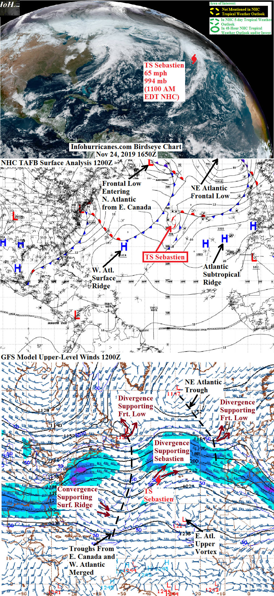
TROPICAL STORM SEBASTIEN...The western Atlantic upper trough fragment that has been supporting Sebastien with its eastern divergence zone has merged with an upper trough and surface frontal cyclone that has emerged from eastern Canada. Given that Sebastien is over cool 20 deg C waters...it is definite that the tropical storm and its thunderstorms remain supported by the eastern divergence zone of the combined upper trough. The National Hurricane Center continues to issue advisories on Sebasiten as a tropical storm citing that enough thunderstorms continue to fire just northeast of the center to consider Sebastien as a tropical entity for the time being. However it appears to me that Sebastien is either a non-tropical frontal cyclone or about to become one with satellite imagery showing a cold front cloud band extending well south of the center. Regarding track...Sebastien has continued to accelerate faster to the northeast than previously anticipated...therefore sea swells should continue to increase across the Azores from now through tomorrow. Also the center of Sebastien it appears it will strike the western Azores with gusty damaging winds by tonight...with the remaining Azores also experiencing gusty and potentially damaging winds from the south side of Sebastien's ciruclation through tomorrow. It previously appeared the frontal low from eastern Canada would gain dominance as the feature supported by the combined upper trough as it heads into western Europe...but now this frontal low has reached its classical mature and weakening phase while becoming aligned directly below the upper trough axis where there is a lack of supporting divergence. Therefore it now appears Sebastien will become the dominant cyclone in the region...which is why I have added the British Isles and northern France as potential areas of impact from Sebastien for Tuesday and Wednesday.
******Infohurricanes.com forecast. Visit hurricanes.gov (hurricanes dot gov) for official forecast***********
0 Hr Position (1200Z Nov 24)...65 mph maximum sustained wind tropical storm centered at 37.4N-37W
IOH 24 Hr Forecast (1200Z Nov 25)...65 mph maximum sustained wind frontal cyclone centered northeast of the Azores at 45N-20.5W


Comments