MY 2019 ATLANTIC HURRICANE SEASON BIRDSEYE VIEW POST #142
- NCHurricane2009

- Sep 29, 2019
- 3 min read
*******Note that forecasts and outlooks in this post are NOT the official forecast from the National Hurricane Center (NHC). They are my own detailed views on the Atlantic tropics based on current observations and latest computer model runs. As such do not make decisions based on my posts...consult news media...watches and warnings from your local weather office...and any evacuation orders issued by local governments to make the most informed and best decisions. Visit the NHC website hurricanes.gov (hurricanes dot gov) for the latest watches/warnings and official forecasts on active tropical cyclones.**********
...SUNDAY SEPTEMBER 29 2019 5:08 PM EDT...
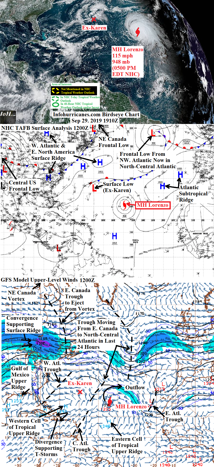
See Lorenzo section below for the only active tropical cyclone in the Atlantic basin. Elsewhere over the next 5 days...a broad area of low pressure is expected to develop over the western Atlantic...western Caribbean...and southeastern Gulf of Mexico as a pattern of upper divergence persists between the east side of the upper trough currently in the western Atlantic and the cell of upper ridging also in the western tropical Atlantic. Will watch to see if a tropical disturbance emerges within this broad low pressure area. So far the the only model that explicitly suggests tropical development is the CMC model...but this model tends to be overly-aggressive. It is interesting to note that there are thunderstorms in the vicnity of the eastern Bahamas...Haiti...and the Dominican Republic supported by an area of divergence between the western Atlantic upper ridge cell and central Atlantic upper trough...will watch to see if this is the beginning of the area of broad low pressure. Meanwhile...the favorable upward motion of the Madden Julian Oscillation (MJO) is beginning to shift east...and could leave the Atlantic basin next week which would reduce the overall tropical activity in the Atlantic (https://www.cpc.ncep.noaa.gov/products/precip/CWlink/MJO/mjo.shtml)
MAJOR HURRICANE LORENZO...Lorenzo shattered a record of being the farthest east category 5 hurricane on record in the Atlantic basin last evening...but today the satellite appearance of Lorenzo tells a different story as some southwesterly shear from an upper trough quickly arriving from eastern Canada has arrived. Although Lorenzo's outflow has kept a portion of this upper trough cut-off and at bay to the west...the shear appears enough to cause the well-defined eye last evening to shrivel away while the heaviest thunderstorm activity has become increasingly lopsised to the northeast half of the circulation. The hurricane has weakened down to a category 3 with 115 mph maximum sustained winds as of the recent 5 PM EDT National Hurricane Center advisory. Based on the degraded appearance of Lorenzo on satellite and currenty intensity...I have notably lowered my intensity forecast from special update #141A. The shearing upper southwesterly flow ahead of the aforementioned upper trough will try to nudge Lorenzo eastward...but the Atlantic subtropical surface ridge will prevent an eastward turn for the early part of the forecast. Once Lorenzo moves past the surface ridge by 48+ hours...it will finally turn increasingly eastward toward the Azores. As it does so...a second a more vigorous upper trough about to eject from eastern Canada will keep Lorenzo energized with tremendous upper divergence on its east side...thus transitioning Lorenzo into a formidable non-tropical remnant gale still packing hurricane-force winds. Therefore it appears damaging winds will overspread the Azores on Tuesdsay evening...interests here should be preparing for the wind and coastal sea swells. My updated forecast track is nudged southwestward given Lorenzo's current position (but is only nudged westward at 72 hours as the latest GFS model run shows Lorenzo moving faster to the northeast than it showed before)...and it appears the most significant effects from Lorenzo in the Azores will be towards the western islands.
******Infohurricanes.com forecast. Visit hurricanes.gov (hurricanes dot gov) for official forecast***********
0 Hr Position (1800Z Sep 29)...115 mph maximum sustained wind major hurricane centered at 26.9N-44.2W
IOH 24 Hr Forecast (1800Z Sep 30)...100 mph maximum susateind wind hurricane centered at 31N-41.5W
IOH 48 Hr Forecast (1800Z Oct 1)...85 mph maximum susateind wind hurricane transitioning to non-tropical centered southwest of the Azores at 36N-36.5W
IOH 72 Hr Forecast (1800Z Oct 2)...75 mph maximum susateind wind non-tropical remnant gale centered north of the Azores at 48.5N-24W


Comments