MY 2022 ATLANTIC HURRICANE SEASON BIRDSEYE VIEW POST #99
- NCHurricane2009

- Sep 13, 2022
- 8 min read
*******Note that forecasts and outlooks in this post are NOT the official forecast from the National Hurricane Center (NHC). They are my own detailed views on the Atlantic tropics based on current observations and latest computer model runs. As such do not make decisions based on my posts...consult news media...watches and warnings from your local weather office...and any evacuation orders issued by local governments to make the most informed and best decisions. Visit the NHC website hurricanes.gov (hurricanes dot gov) for the latest watches/warnings and official forecasts on active tropical cyclones.**********
...TUESDAY SEPTEMBER 13 2022 2:45 AM EDT...
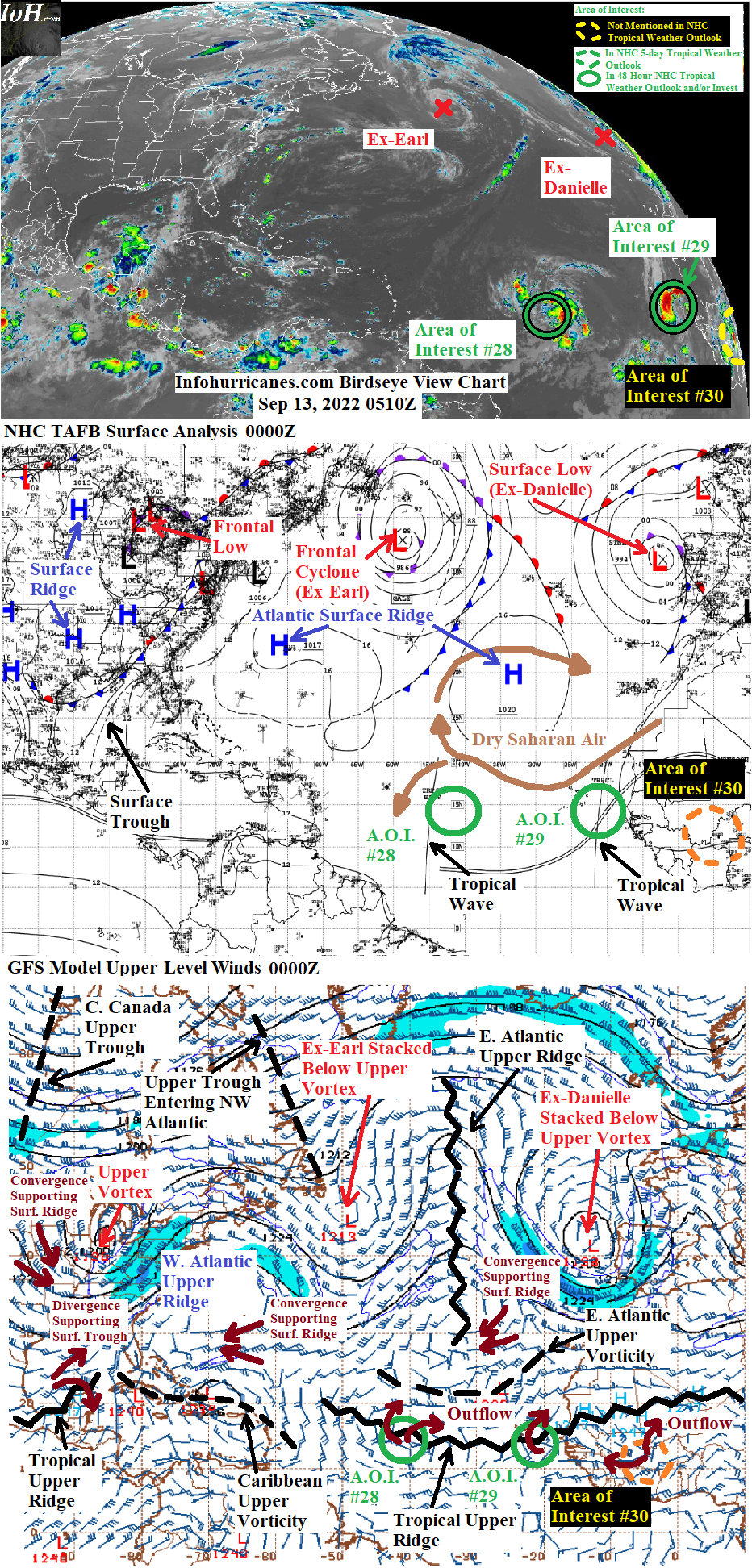
The low-latitudes of the tropical Atlantic beginning to see more activity while watching a series of tropical waves from the central tropical Atlantic to western Africa that have become better organized... see area of interest #28 to #30 sections below for more information.
New to this site this year... I will be sequentially numbering up areas of interest for possible Atlantic tropical development. In this scheme... will reset back to #1 at the start of next year (January 2023). The current areas of interest in this blog post are designated #28 to #30 as the other twenty-seven were mentioned in previous birdseye view posts. This scheme is to reduce confusion as Atlantic tropical activity increases during the peak of the hurricane season... when multiple simultaneous areas of interest begin and end which previously required shuffling around the area of interest numbers from update to update.
AREA OF INTEREST #28...The axis of the tropical wave of low pressure currently in the central tropical Atlantic is crossing 45W longitude as previously forecast for this timeframe. However the thunderstorm activity on the east side of the axis is gradually becoming better organized while suggesting a low pressure circulation near 14N-41.5W as of 0000Z earlier this evening. The CIMSS 850 mb vorticity product also suggests a gradually consolidating circulation to the east of the wave axis (https://tropic.ssec.wisc.edu/real-time/windmain.php?basin=atlantic&sat=wg8&prod=vor&zoom=&time=). This system is expected to continue steadily westward across the tropical Atlantic and around the south side of the current Atlantic surface ridge. The updated forecast track below is adjusted north and east based on the current position of the low pressure circulation that is located east of instead of over the wave axis. The remnant frontal cyclone of Earl going forward will continue to weaken while remaining trapped beneath the core of its associated upper vortex where there is a lack of upper divergence... causing the associated surface ridge weakness to close which is why this area of interest is slated to continue westward. In 72 to 120 hours... a vigorous frontal system is expected over eastern Canada and the northwest Atlantic. The tail end of this frontal system is expected to deposit a cut-off upper trough/vortex over the southeastern United States whose eastern divergence zone is expected to generate an offshore frontal low. The northward component of this area of interests's westward track is likely to increase by day 5 while moving toward the frontal low forecast to be offshore of the southeastern United States.
Even though this tropical wave of interest is becoming better organized... due to the aforementioned development of the low pressure circulation just east of the wave axis as discussed above... I still cap my peak odds of tropical cyclone formation to 20% due to uncertainty in the longer range upper wind forecast. However in this update I acknowledge the improved organization by ramping up to the 20% a little faster than I previously showed. The uncertain upper wind pattern in the longer range lies with the development of the vigorous frontal system is expected over eastern Canada and the northwest Atlantic expected in the 72 to 120 hour timeframe. The warm sector of the frontal system is expected to build an upper ridge over the western Atlantic that cuts-off some of the upper vorticity tied to Earl's remnant system and sends it southwestward toward this tropical wave. In the unfavorable scenario... the upper vorticity catches up to the wave where it would increase wind shear and suppress upper outflow. In the favorable scenario... the upper vorticity does not quiet catch up to the wave... leaving the wave in a favorable split flow upper divergence pattern between the west side of the upper vorticity and southeast side of the built-up western Atlantic upper ridge (noting the NAVGEM wants to strengthen this tropical wave into a strong tropical cyclone while picking up on this potentially favorable upper wind scenario). Once it becomes clear which scenario will take shape... odds of development could either increase or decrease above the 20% in future updates. Note that interests in the northern Lesser Antilles... Virgin Islands... and Puerto Rico may see gusty winds and heavy rains from this tropical wave late this week and into the weekend.
******Infohurricanes.com outlook. Visit hurricanes.gov (hurricanes dot gov) for official outlook***********
IOH 24 Hr Outlook (0000Z Sep 14)...10% chance of tropical cyclone formation (central tropical Atlantic near 15N-46.5W)
IOH 48 Hr Outlook (0000Z Sep 15)...20% chance of tropical cyclone formation (central tropical Atlantic near 16N-51.5W)
IOH 72 Hr Outlook (0000Z Sep 16)...20% chance of tropical cyclone formation (east of the northern Lesser Antilles near 17N-57W)
IOH 96 Hr Outlook (0000Z Sep 17)...20% chance of tropical cyclone formation (just north of the northern Lesser Antilles near 18N-62W)
IOH 120 Hr Outlook (0000Z Sep 18)...20% chance of tropical cyclone formation (north of Puerto Rico near 20N-66W)
AREA OF INTEREST #29...As anticipated over the last few days... we now have a tropical disturbance offshore of western Africa. The disturbance consists of a tropical wave of low pressure that has recently departed the west coast of Africa. This wave has continued to feature an area of rotation with somewhat organized thunderstorm activity on its west side. Recently the thunderstorm activity has increased in intensity and organization while wrapping into the area of rotation... indicating the tropical wave is walling-off the dry Saharan air in the region. As a result we can now expect heavy rainfall and gusty winds across the Republic of Cabo Verde Islands today... and the odds of tropical cyclone formation appear to be increasing.
As of 0000Z the organizing area of rotation was located just southeast of the Republic of Cabo Verde Islands... near 13.5N-21W. The updated forecast track is adjusted based on this current position. A general westward track around the south side of the Atlantic surface ridge is anticipated over the next few days. In the next 72 hours... the northward angle in this disturbance's westward track is possible as this system potentially ramps up into a strong/tall enough circulation to be pulled by the upper southerly flow on the east side of current eastern Atlantic upper vorticity lingering to the northwest...with this upper vorticity becoming re-enforced by vorticity to become cut-off from Earl's remnant system as an upper ridge builds over the western Atlantic (more info on this upper wind pattern was discussed in the above area of interest #28 section). For the initial 72-hour period I set odds of tropical cyclone formation to an initially higher 40% due to the marked improvement in this system's current organization... with odds trimmed down to 30% by 72 hours as this system potentially nears the stronger shearing upper winds associated with the east side of the upper vorticity. For the 96 to 120 hour period... the upper vorticity is expected to accelerate westward and away around the western Atlantic upper ridge... resulting in a more westward track and a relaxation in shear such that I raise odds of development back up to 40%. In this update I have not yet selected odds above 40% as this system could still end up ingesting dry Saharan air. However should the current organization trends in this disturbance continue... development odds will be increased in a special update later today or in the next full update about 24 hours from now.
******Infohurricanes.com outlook. Visit hurricanes.gov (hurricanes dot gov) for official outlook***********
IOH 24 Hr Outlook (0000Z Sep 14)...40% chance of tropical cyclone formtion (just southwest of the Republic of Cabo Verde Islands near 14.5N-25.5W)
IOH 48 Hr Outlook (0000Z Sep 15)...40% chance of tropical cyclone formation (eastern tropical Atlantic near 16N-30W)
IOH 72 Hr Outlook (0000Z Sep 16)...30% chance of tropical cyclone formation (eastern tropical Atlantic near 17.5N-34W)
IOH 96 Hr Outlook (0000Z Sep 17)...40% chance of tropical cyclone formation (eastern tropical Atlantic near 18N-39W)
IOH 120 Hr Outlook (0000Z Sep 18)...40% chance of tropical cyclone formation (central tropical Atlantic near 19N-44W)
AREA OF INTEREST #30...Satellite image of tropical wave of low pressure currently over western Africa... image taken at 0600Z:

An additional tropical wave of low pressure currently over western Africa... trailing behind area of interest #29... as of 0000Z earlier this evening was exhibiting an area of rotation near 10N-5.5W with some signs of organized banding features in its showers and thunderstorms. It is clear that this wave will not become entangled with area of interest #29 while it continues to have its own distinct identity... and I have initialized it as its own area of interest in this update due to its current signs of organization. Favoring this tropical wave as it moves into and across the eastern tropical Atlantic at 72+ hours is the persistent tropical upper ridge in the region featuring low shear and upper outflow. However I have low 20% peak odds of tropical cyclone formation due to the current lack of computer model support showing development... and will have to wait and see how this wave later interacts with the dry Saharan air before suggesting any higher odds of tropical cyclone formation. On the one hand dry air has been a problem for tropical development in the eastern tropical Atlantic this hurricane season... on the other hand the increase in the organization and thunderstorm activity in areas of interest #28 and #29 suggest that the influence of dry air may finally be letting up.
******Infohurricanes.com outlook. Visit hurricanes.gov (hurricanes dot gov) for official outlook***********
IOH 24 Hr Outlook (0000Z Sep 14)...0% chance of tropical cyclone formation (western Africa near 10.5N-10.5W)
IOH 48 Hr Outlook (0000Z Sep 15)...0% chance of tropical cyclone formation (west coast of Africa near 10.5N-15.5W)
IOH 72 Hr Outlook (0000Z Sep 16)...10% chance of tropical cyclone formation (eastern tropical Atlantic near 11N-20.5W)
IOH 96 Hr Outlook (0000Z Sep 17)...15% chance of tropical cyclone formation (eastern tropical Atlantic near 11.5N-25.5W)
IOH 120 Hr Outlook (0000Z Sep 18)...20% chance of tropical cyclone formation (eastern tropical Atlantic near 12N-30W)
...COMPUTER MODEL SUMMARY...
Source...Florida State University Experimental Forecast Tropical Cyclone Genesis Potential Fields (http://moe.met.fsu.edu/tcgengifs/)
1200Z (Sep 12) CMC Model Run...
**For area of interest #28... no development shown
**For area of interest #29... organizes into a tropical low just southeast of the Republic of Cabo Verde Islands at 18 hours which passes just south of the islands through 30 hours... tropical low opens back to a wave at 72 hours while passing 34W longitude.
**For area of interest #30... no development shown
1200Z (Sep 12) ECMWF Model Run...
**For area of interest #28... no development shown
**For area of interest #29... organizes into a broad tropical low just south of the Republic of Cabo Verde Islands at 24 hours... tropical low opens back to a wave near 39W at 96 hours
**For area of interest #30... no development shown
1800Z (Sep 12) GFS Model Run...
**For area of interest #28... no development shown
**For area of interest #29... no development shown
**For area of interest #30... no development shown
1800Z (Sep 12) NAVGEM Model Run...
**For area of interest #28... tropical cyclone formation suggested near 16.5N-31.5W at 54 hours... while passing just northeast of the Lesser Antilles through 120 hours intensifies into a hurricane.
**For area of interest #29... no development shown
**For area of interest #30... no development shown


Comments