MY 2021 ATLANTIC HURRICANE SEASON BIRDSEYE VIEW POST #77A (Special Update)
- NCHurricane2009

- Aug 12, 2021
- 4 min read
*******Note that forecasts and outlooks in this post are NOT the official forecast from the National Hurricane Center (NHC). They are my own detailed views on the Atlantic tropics based on current observations and latest computer model runs. As such do not make decisions based on my posts...consult news media...watches and warnings from your local weather office...and any evacuation orders issued by local governments to make the most informed and best decisions. Visit the NHC website hurricanes.gov (hurricanes dot gov) for the latest watches/warnings and official forecasts on active tropical cyclones.**********
...THURSDAY AUGUST 12 2021 6:30 AM EDT...

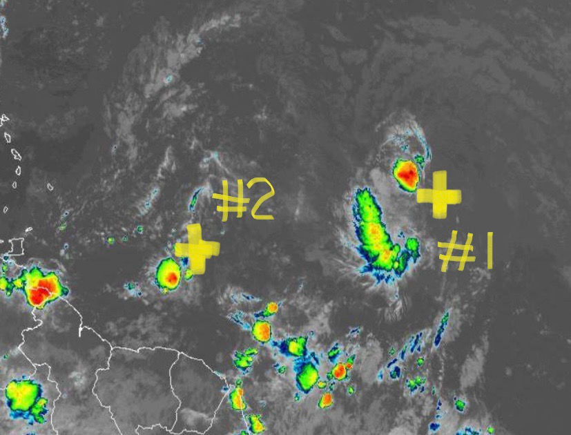
This special update is to update areas of interest #1 and #2 that were not updated in post #77…. the center of both systems is marked with a yellow plus in the above satellite picture. Visit post #77 on the home page of this site for an update on Fred.
AREA OF INTEREST #1… The strong tropical wave of low pressure in the eastern tropical Atlantic has tracked a little further north and also faster… already nearing the central Atlantic waters past 40W longitude while its center of rotation is estimated to be near 13N-39W early this morning. This track suggests this system is being channeled into stronger east-southeasterly flow on the east side of the larger tropical wave to the west associated with area of Interest #2… and with the models on agreement that this track will continue I have adjusted my forecast track below accordingly. At 120 hours the forecast track is to bent more north in response to the surface ridge weakness created by Fred in the eastern Gulf of Mexico and also the lingering tail end of a front over the interior southeast US (front to be left behind by the current Canadian frontal cyclone).
The tropical wave for the better part of the last 36 hours has become less organized due to dry Saharan air appearing to limit thunderstorm activity on the northeast side of the circulation… and so my odds of development are lowered in the short-term compared to where I put them in my previous Outlook in discussion #76 on Tuesday afternoon. The NHC as of this writing has risen their peak development odds to 60% in their 5-day outlook… same as my previous Outlook. I still agree with those odds due to the well-defined surface swirl the wave still has… especially as the wave will tend to move into the central tropical Atlantic where the dry Saharan air concentrations tend to be lower. However by day 5 I lower odds of development down to 30% due to possible westerly shear from a lingering western Atlantic upper vorticity Forecast to be northeast of the Bahamas.
Interests in the northern Lesser Antilles… Virgin Islands… and Puerto Rico are encouraged to monitor the progress of this tropical wave as its forecast to pass over or nearby by Sunday and Monday.
******Infohurricanes.com outlook. Visit hurricanes.gov (hurricanes dot gov) for official outlook***********
IOH 24 Hr Outlook (0600Z Aug 13)…30% chance of tropical cyclone formation (central tropical Atlantic near 15N-46W)
IOH 48 Hr Outlook (0600Z Aug 14)…50% chance of tropical cyclone formation (central tropical Atlantic near 16N-52W)
IOH 72 Hr Outlook (0600Z Aug 15)…60% chance of tropical cyclone formation (east of the northern Lesser Antilles near 17N-58W)
IOH 96 Hr Outlook (0600Z Aug 16)…40% chance of tropical cyclone formation (Virgin Islands near 18N-64W)
IOH 120 Hr Outlook (0600Z Aug 17)…30% chance of tropical cyclone formation (east of the eastern Bahamas near 21N-69W)
AREA OF INTEREST #2… The south side of the broad tropical wave of low pressure in the central tropical Atlantic… the same wave that was formerly tagged invest 92-L… as of yesterday afternoon developed a concentrated area of thunderstorms and rotation. Thru last night and this morning the thunderstorm activity is notably less while the spin has become less defined near 10N-52.5W… perhaps while competing for surface inflow with the rest of the broad tropical wave’s circulation… and so I assign low 10% odds of development over the next five days as this area of rotation passes thru the southern Lesser Antilles and across the southern Caribbean Sea. At 120 hours the forecast track is to bent more north in response to the surface ridge weakness created by Fred in the eastern Gulf of Mexico and also the lingering tail end of a front over the interior southeast US (front to be left behind by the current Canadian frontal cyclone). On this forecast track… this feature is poised to stay south of the less favorable west Atlantic upper vorticity that is negatively affecting Fred and is forecast to negatively affect area of interest #1 in the coming days… so the only inhibiting factor is the large broad nature of the tropical wave which will make it harder for the development of a tighter smaller circulation needed for tropical development.
******Infohurricanes.com outlook. Visit hurricanes.gov (hurricanes dot gov) for official outlook***********
IOH 24 Hr Outlook (0600Z Aug 13)…5% chance of tropical cyclone formation (east of Trinidad and Tobago near 11N-58W)
IOH 48 Hr Outlook (0600Z Aug 14)…10% chance of tropical cyclone formation (offshore of northeast Venezuela near 12N-63W)
IOH 72 Hr Outlook (0600Z Aug 15)…10% chance of tropical cyclone formation (eastern Caribbean Sea near 13N-68W)
IOH 96 Hr Outlook (0600Z Aug 16)…10% chance of tropical cyclone formation (Central Caribbean Sea near 14N-73W)
IOH 120 Hr Outlook (0600Z Aug 17)…10% chance of tropical cyclone formation (southwest of Jamaica near 16.2N-78W)


Comments